Mountain Park, Gwinnett County, Georgia

Last updated
Mountain Park, Georgia
Five Forks Trickum Road, Mountain Park, Gwinnett County, GA.jpg
Five Forks Trickum Road
Gwinnett County Georgia Incorporated and Unincorporated areas Mountain Park Highlighted.svg
Location in Gwinnett County and the state of Georgia
Coordinates: 33°50′39″N84°07′46″W / 33.84417°N 84.12944°W / 33.84417; -84.12944
CountryUnited States
State Georgia
Counties Gwinnett
Area
  Total5.8 sq mi (15 km2)
  Land5.8 sq mi (15 km2)
  Water0 sq mi (0 km2)
Elevation
[1]
1,024 ft (312 m)
Population
 (2010)
  Total11,554
  Density2,026.4/sq mi (783.5/km2)
GNIS feature ID1867244 [1]

Mountain Park is an unincorporated community and census-designated place (CDP) in Gwinnett County, Georgia, United States. The population was 11,554 at the 2010 census. [2] The older name for the area is Trickum, which is reflected in Five Forks-Trickum Road which bisects the community. The older community was centered on Five Forks and Rockbridge Roads.

Contents

Geography

According to the United States Census Bureau, the CDP has a total area of 5.8 square miles (15 km2), of which 5.8 square miles (15 km2) is land and 0.17% is water.

Demographics

Historical population
CensusPop.Note
1980 9,425
1990 11,02517.0%
2000 11,7536.6%
2010 11,554−1.7%
2020 13,08913.3%
U.S. Decennial Census [3]
1850-1870 [4] 1870-1880 [5]
1890-1910 [6] 1920-1930 [7]
1940 [8] 1950 [9] 1960 [10]
1970 [11] 1980 [12] 1990 [13]
2000 [14] 2010 [15] 2020 [16]

Mountain Park first appeared as a census designated place in the 1980 U.S. Census. [12]

2020 census

Mountain Park, Georgia – Racial and ethnic composition
Note: the US Census treats Hispanic/Latino as an ethnic category. This table excludes Latinos from the racial categories and assigns them to a separate category. Hispanics/Latinos may be of any race.
Race / Ethnicity (NH = Non-Hispanic)Pop 2000 [17] Pop 2010 [15] Pop 2020 [16] % 2000% 2010% 2020
White alone (NH)9,4757,4486,09280.62%64.46%46.54%
Black or African American alone (NH)6941,6462,6015.90%14.25%19.87%
Native American or Alaska Native alone (NH)2540380.21%0.35%0.29%
Asian alone (NH)1,0681,3612,2049.09%11.78%16.84%
Pacific Islander alone (NH)31010.03%0.09%0.01%
Some Other Race alone (NH)2522750.21%0.19%0.57%
Mixed Race or Multi-Racial (NH)1502384761.28%2.06%3.64%
Hispanic or Latino (any race)3137891,6022.66%6.83%12.24%
Total11,75311,55413,089100.00%100.00%100.00%

As of the 2020 United States census, there were 13,089 people, 4,516 households, and 3,559 families residing in the CDP.

2000 census

As of the census [18] of 2000, there were 11,753 people, 4,282 households, and 3,378 families residing in the CDP. The population density was 2,025.4 inhabitants per square mile (782.0/km2). There were 4,444 housing units at an average density of 765.9 per square mile (295.7/km2). The racial makeup of the CDP was 82.15% White, 5.96% African American, 0.23% Native American, 9.10% Asian, 0.03% Pacific Islander, 1.00% from other races, and 1.55% from two or more races. Hispanic or Latino of any race were 2.66% of the population.

There were 4,282 households, out of which 35.4% had children under the age of 18 living with them, 67.0% were married couples living together, 8.8% had a female householder with no husband present, and 21.1% were non-families. 17.7% of all households were made up of individuals, and 6.7% had someone living alone who was 65 years of age or older. The average household size was 2.73 and the average family size was 3.10.

In the CDP, the population was spread out, with 24.5% under the age of 18, 6.7% from 18 to 24, 25.7% from 25 to 44, 31.2% from 45 to 64, and 11.8% who were 65 years of age or older. The median age was 41 years. For every 100 females, there were 93.9 males. For every 100 females age 18 and over, there were 92.2 males.

The median income for a household in the CDP was $62,892, and the median income for a family was $70,768. Males had a median income of $47,436 versus $31,608 for females. The per capita income for the CDP was $28,454. About 2.2% of families and 3.4% of the population were below the poverty line, including 3.5% of those under age 18 and 4.9% of those age 65 or over.

Education

The county operates Gwinnett County Public Schools.

Gwinnett County Public Library operates the Mountain Park Branch. [19]

Related Research Articles

<span class="mw-page-title-main">Rock Creek, Alabama</span> CDP in Alabama, United States

Rock Creek is a census-designated place in Jefferson County, Alabama, United States. Its location is northwest of Hueytown. At the 2020 census, the population was 1,471. This area was damaged by an F5 tornado on April 8, 1998. An EF2 tornado struck northwest from here on January 23, 2012.

<span class="mw-page-title-main">Ives Estates, Florida</span> Census-designated place in Florida

Ives Estates is a census-designated place (CDP) in Miami-Dade County, Florida. It is part of the Miami metropolitan area of South Florida. The population was 25,005 at the 2020 census, up from 19,525 in 2010.

<span class="mw-page-title-main">Kendall West, Florida</span> Census-designated place in Florida

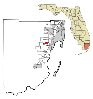
Kendall West is a census-designated place and unincorporated community in Miami-Dade County, Florida, west of the Florida Turnpike. It is located in the Miami metropolitan area of South Florida. The population was 36,536 at the 2020 census.

<span class="mw-page-title-main">Olympia Heights, Florida</span> Census-designated place in Florida

Olympia Heights is a census-designated place in Miami-Dade County, Florida, United States. It is located in the Miami metropolitan area of South Florida. The population was 12,873 at the 2020 census.

<span class="mw-page-title-main">Lakeview, Georgia</span> Place in Georgia, United States

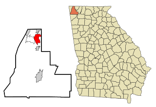
Lakeview is an unincorporated community and census-designated place (CDP) in Catoosa and Walker counties in the U.S. state of Georgia. The population was 4,820 at the 2000 census and 4,777 at the 2020 census. It is part of the Chattanooga, TN–GA Metropolitan Statistical Area.

<span class="mw-page-title-main">Bonanza, Georgia</span> Place in Georgia, United States

Bonanza is an unincorporated community and census-designated place (CDP) in Clayton County, Georgia, United States. The population was 3,135 at the 2010 census.

<span class="mw-page-title-main">Belvedere Park, Georgia</span> Place in Georgia, United States

Belvedere Park is an unincorporated community and census-designated place (CDP) in DeKalb County, Georgia, United States. The population was 15,113 at the 2020 census.

<span class="mw-page-title-main">Candler-McAfee, Georgia</span> Place in Georgia, United States

Candler-McAfee is an unincorporated community and census-designated place (CDP) in DeKalb County, Georgia, United States. It is located east of Atlanta approximately 10 miles (16 km) east of Downtown Atlanta and to the south of Decatur, Georgia The population was 23,025 at the 2010 census.

<span class="mw-page-title-main">Gresham Park, Georgia</span> Place in Georgia, United States

Gresham Park is an unincorporated community and census-designated place (CDP) in DeKalb County, Georgia, United States. The population was 7,700 at the 2020 census.

<span class="mw-page-title-main">North Decatur, Georgia</span> Place in Georgia, United States

North Decatur is an unincorporated community and census-designated place (CDP) in DeKalb County, Georgia, United States. The population was 16,698 at the 2010 census.

<span class="mw-page-title-main">Lindale, Georgia</span> Place in Georgia, United States

Lindale is an unincorporated community and census-designated place (CDP) in Floyd County, Georgia, United States. It is part of the Rome, Georgia Metropolitan Statistical Area. The population was 4,191 at the 2010 census.

<span class="mw-page-title-main">Lilburn, Georgia</span> City in Georgia, United States

Lilburn is a city in Gwinnett County, Georgia, United States. The population was 14,502 at the 2020 census. The estimated population was 12,810 in 2019. It is a part of the Atlanta metropolitan area.

<span class="mw-page-title-main">Hilltop, Georgia</span> Place in Georgia, United States

Hilltop is an unincorporated community and census-designated place (CDP) in Pike County, Georgia, United States. The population was 401 at the 2000 census.

<span class="mw-page-title-main">East Griffin, Georgia</span> Place in Georgia, United States

East Griffin is an unincorporated community and census-designated place (CDP) in Spalding County, Georgia, United States. The population was 1,635 at the 2000 census.

<span class="mw-page-title-main">Experiment, Georgia</span> Place in Georgia, United States

Experiment is an unincorporated community and census-designated place (CDP) in Spalding County, Georgia, United States. The population was 3,233 at the 2000 census.

<span class="mw-page-title-main">Sunset Village, Georgia</span> Place in Georgia, United States

Sunset Village is an unincorporated community and census-designated place (CDP) in Upson County, Georgia, United States. The population was 871 at the 2000 census.

<span class="mw-page-title-main">Fairview, Georgia</span> Place in Georgia, United States

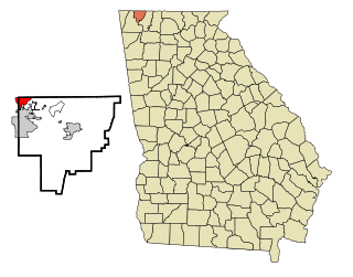
Fairview is an unincorporated community and census-designated place (CDP) in Walker County, Georgia, United States. In the 2020 census, the population was 6,409. It is part of the Chattanooga, TN–GA Metropolitan Statistical Area.

Fox Lake Hills is an unincorporated community and census-designated place (CDP) in Lake Villa Township, Lake County, Illinois, United States. Per the 2020 census, the population was 2,684.

<span class="mw-page-title-main">Frankfort Square, Illinois</span> Census-designated place in Illinois, United States

Frankfort Square is a census-designated place (CDP) in Will County, Illinois, United States. Per the 2020 census, the population was 8,968.

<span class="mw-page-title-main">South Miami Heights, Florida</span> Census-designated place in Florida

South Miami Heights is a census-designated place (CDP), originally known as Eureka, in Miami-Dade County, Florida. It is part of the Miami metropolitan area of South Florida. The population was 36,770 as of the 2020 census.

References

  1. 1 2 U.S. Geological Survey Geographic Names Information System: Mountain Park, Gwinnett County, Georgia
  2. "US Gazetteer files: 2010, 2000, and 1990". United States Census Bureau. 2011-02-12. Retrieved 2011-04-23.
  3. "Decennial Census of Population and Housing by Decade". United States Census Bureau.
  4. "1870 Census of Population - Georgia - Population of Civil Divisions less than Counties" (PDF). United States Census Bureau. 1870.
  5. "1880 Census of Population - Georgia - Population of Civil Divisions less than Counties" (PDF). United States Census Bureau. 1880.
  6. "1910 Census of Population - Georgia" (PDF). United States Census Bureau. 1930.
  7. "1930 Census of Population - Georgia" (PDF). United States Census Bureau. 1930. pp. 251–256.
  8. "1940 Census of Population - Georgia" (PDF). United States Census Bureau. 1940.
  9. "1950 Census of Population - Georgia" (PDF). United States Census Bureau. 1980.
  10. "1960 Census of Population - Population of County Subdivisions - Georgia" (PDF). United States Census Bureau. 1960.
  11. "1970 Census of Population - Population of County Subdivisions - Georgia" (PDF). United States Census Bureau. 1970.
  12. 1 2 "1980 Census of Population - Number of Inhabitants - Georgia" (PDF). United States Census Bureau. 1980.
  13. "1990 Census of Population - Summary Social, Economic, and Housing Characteristics - Georgia" (PDF). United States Census Bureau. 1990.
  14. "2000 Census of Population - General Population Characteristics - Georgia" (PDF). United States Census Bureau. 2000.
  15. 1 2 "P2 Hispanic or Latino, and Not Hispanic or Latino by Race - 2010: DEC Redistricting Data (PL 94-171) – Mountain Park CDP, Georgia". United States Census Bureau .
  16. 1 2 "P2 Hispanic or Latino, and Not Hispanic or Latino by Race - 2020: DEC Redistricting Data (PL 94-171) – Mountain Park CDP, Georgia". United States Census Bureau .
  17. "P004 Hispanic or Latino, and Not Hispanic or Latino by Race – 2000: DEC Summary File 1 – Mountain Park CDP, Georgia". United States Census Bureau .
  18. "U.S. Census website". United States Census Bureau . Retrieved 2008-01-31.
  19. "Hours & Locations Archived 2010-07-26 at the Wayback Machine ." Gwinnett County Public Library. Retrieved on February 24, 2010.