Centro Habana

Last updated
Centro Habana
Centro Habana & Vedado.jpg
Centro Havana seen from Hotel Habana Libre
Coat of arms of Centro Habana.jpg
Havana Map - Centro Habana.png
Location of Centro Habana in Havana
Coordinates: 23°08′0″N82°23′0″W / 23.13333°N 82.38333°W / 23.13333; -82.38333
Country Cuba
Province Ciudad de La Habana
Wards (Consejos Populares) Cayo Hueso, Colón, Dragones, Los Sitios, Pueblo Nuevo
Area
[1]
  Total4 km2 (2 sq mi)
Elevation
45 m (148 ft)
Population
 (2021) [2]
  Total132,451
  Density33,000/km2 (86,000/sq mi)
Time zone UTC-5 (EST)
Area code +53-7

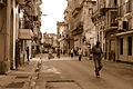
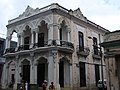
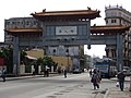
Centro Habana is one of the 15 municipalities or boroughs ( municipio s in Spanish) in the city of Havana, Cuba. A chinatown - Barrio Chino - is also located in this district. It is a smaller municipality of Havana, and it has the highest population density.

Contents

Centro Habana is divided into five consejos populares (wards): Cayo Hueso, Colón, Dragones, Los Sitios and Pueblo Nuevo.

History

The infrastructure of the city, built 450 years ago, heavily deteriorated during the 1990s after the collapse of the Cuban-Soviet trade partnership. In 1996, restoration projects were started to improve housing and infrastructure in the Cayo Hueso community. [3]

Centro Habana was established as an administrative division in 1963 and later formally made its own municipio in 1976. [4]

Demographics

In 2004, the municipality of Centro Habana had a population of 158,151. [2] With a total area of 4 km2 (1.5 sq mi), [1] it has a population density of 39,537.8 inhabitants per square kilometre (102,402/sq mi).

See also

Related Research Articles

<span class="mw-page-title-main">Havana</span> Capital and largest city of Cuba

Havana is the capital and largest city of Cuba. The heart of the La Habana Province, Havana is the country's main port and commercial center. It is the most populous city, the largest by area, and the second largest metropolitan area in the Caribbean region. The population in 2002 was 2,137,847 inhabitants, and its area is 728.26 km2 (281.18 sq mi) for the capital city side and 8,475.57 km2 for the metropolitan zone.

<span class="mw-page-title-main">Caibarién</span> Municipality in Villa Clara, Cuba

Caibarién is a municipality city in the Villa Clara province of Cuba.

<span class="mw-page-title-main">San Antonio de los Baños</span> Municipality in Artemisa, Cuba

San Antonio de los Baños is a municipality and town in the Artemisa Province of Cuba. It is located 26 km from the city of Havana, and the Ariguanabo River runs through it. It was founded in 1802.

<span class="mw-page-title-main">Vedado</span> Urban neighborhood in the city of Havana, Cuba

Vedado is a central business district and urban neighborhood in the city of Havana, Cuba. Bordered on the east by Calzada de Infanta and Central Havana, and on the west by the Alemendares River and Miramar / Playa district, Vedado is a more modern part of the city than the areas to the east, developed in the first half of the 20th century, during the Republic period. In 2016 it was described by one commentator as the city's "most affluent" section. The main street running east to west is Calle 23, also known as "La Rampa". The northern edge of the district is the waterfront seawall known as the Malecón, a famous and popular place for social gatherings in the city. The area popularly referred to as 'Vedado' consists of the wards of Vedado, Rampa, Vedado-Malecón and Carmelo, all in the municipality of Plaza de la Revolución.

<span class="mw-page-title-main">Mayarí</span> Municipality in Holguín, Cuba

Mayarí is a municipality and town in the Holguín Province of Cuba.

<span class="mw-page-title-main">Playa, Havana</span> Municipality of Havana in Ciudad de La Habana, Cuba

Playa is a Cuban municipality, located in the Havana province. It covers an area of 36.8 square kilometers, which makes up 8.95% of the provincial extension.

<span class="mw-page-title-main">Malecón, Havana</span> Broad esplanade, roadway and seawall in Havana, Cuba

The Malecón is a broad esplanade, roadway, and seawall that stretches for 8 km along the coast in Havana, Cuba, from the mouth of Havana Harbor in Old Havana, along the north side of the Centro Habana neighborhood and the Vedado neighborhood, ending at the mouth of the Almendares.

<span class="mw-page-title-main">Limonar</span> Municipality in Matanzas, Cuba

Limonar is a municipality and town in the Matanzas Province of Cuba.

<span class="mw-page-title-main">Batabanó, Cuba</span> Municipality in Mayabeque, Cuba

Batabanó is a municipality and town in the Mayabeque Province of Cuba. It was founded in 1688.

<span class="mw-page-title-main">Miguelito Valdés</span> Cuban singer

Miguelito Valdés, also known as Mr. Babalú, was a renowned Cuban singer. His performances were characterized by a strong voice and a particular sense of cubanismo.

<span class="mw-page-title-main">Hermanos Ameijeiras Hospital</span> Hospital in Havana, Cuba

The Hermanos Ameijeiras Hospital, officially the Hospital Clínico Quirúrgico "Hermanos Ameijeiras", is located in Barrio San Lazaro and is the premier hospital in Cuba, its tower prominently visible from the Malecón between the historic center and the uptown Vedado neighborhood. It was opened in 1982.

<span class="mw-page-title-main">Cayo Hueso, Havana</span> Ward of Havana in Ciudad de La Habana, Cuba

Cayo Hueso is a consejo popular (ward) in the municipality of Centro Habana, Havana, Cuba. A traditionally working-class neighborhood populated by Afro-Cubans, it is known for its many cultural landmarks such as the Callejón de Hamel, the Fragua Martiana Museum and the Parque de los Mártires Universitarios.

<span class="mw-page-title-main">La Casa de Beneficencia y Maternidad de La Habana</span> Former orphanage in Cuba

La Casa de Beneficencia y Maternidad de La Habana, was for 270 years Havana's repository of Havana's unwanted children. The House of Charity started during a time when Cuba was experiencing extreme poverty, unemployment, and corruption in the government. Corrupt leaders were plundering the public treasury and little attention was given to social assistance, health, education, or the protection of the poor: "los desamparados".

<span class="mw-page-title-main">Hospital de San Lázaro, Havana</span> Hospital in Havana, Cuba

Hospital de San Lázaro was a hospital in the city of Havana, Cuba. It dates back to the 17th century, when it served as headquarters for some huts built near the Caleta de Juan Guillén, then known as Caleta de San Lázaro, in an area about a mile outside the city walls.

<span class="mw-page-title-main">Barrio de San Lázaro, Havana</span> Neighborhood in Havana, Cuba

Barrio de San Lázaro is one of the first neighbourhoods in Havana, Cuba. It initially occupied the area bounded by Calle Infanta to the west, Calle Zanja to the south, Calle Belascoáin to the east, and the Gulf of Mexico to the north, forming the western edge of Centro Habana. According to the 1855 Ordenanzas Municipales of the city of Havana, Barrio San Lázaro was the Tercer Distrito and was Barrio No. 8.

<span class="mw-page-title-main">La Habana Province (1976–2010)</span> Province in Cuba

Havana Province was one of the provinces of Cuba from 1976, when the nation's provincial structure was revised, through the end of 2010. On January 1, 2011, the province was divided into two new provinces, Artemisa and Mayabeque. La Habana Province had 711,066 people in the 2002 census. The largest city was Artemisa (81,209), as the much larger city of Havana was structured in a different province, Ciudad de La Habana Province.

<span class="mw-page-title-main">Caleta de San Lazaro</span>

Arcabuco was the name of a footpath starting in Old Havana, in the vicinity of the church of Loma del Ángel, and ran in a westerly direction to an inlet cove of approximately 93 metres (305 ft) wide and 5.5 metres (18 ft) in depth. When Juan Guillén a Spanish soldier installed a carpentry shop to build small boats close to the cove the site became known as “La Caleta de Juan Guillén”, the road was known as “the caleta”. Eventually the Hospital de San Lázaro, the Espada Cemetery, the San Dionisio mental asylum, and La Casa de Beneficencia were developed in close proximity to the Caleta de San Lazaro.

<span class="mw-page-title-main">Torreón de San Lázaro</span> Defense in Havana, Cuba

El Torreón de San Lázaro is round tower of masonry built on the shore of the Caleta de San Lazaro. The Torreón de San Lázaro is approximately 4.57 metres (15.0 ft) in diameter and 9.14 metres (30.0 ft) high with embrasures along its wall at the intermediate level and a battlement parapet at the third level roof. It has a wooden entry door at ground level. With the passage of time, the San Lazaro cove was filled and the tower was included in a Republican-era park named after Major General Antonio Maceo. In an 1853 map of Havana it is shown as the Torreón de Vijias (lookouts). In 1982, the Torreón was inscribed along with other historic sites in Old Havana on the UNESCO World Heritage List, because of the city's importance in the European conquest of the New World and its unique architecture.

<span class="mw-page-title-main">Batería de la Reina</span> Colonial defense fortress in Havana

Batería de la de la Reina, built between 1856 and 1861, was a colonial military defense fortress that had accommodations for a garrison of 250 men and 44 pieces of artillery. It was demolished in 1901. Its site was in the esplanade that today occupies the Antonio Maceo park. The fort was a semi-circular building with a 44-gun battery facing the sea. Its fires intersected with those of the Santa Clara Battery and the “Castillo de la Punta”.

<span class="mw-page-title-main">Antonio Maceo monument, Havana</span> Sculpture in Havana, Cuba

The Antonio Maceo monument is a 1916 bronze statue by the Italian sculptor Doménico Boni located in the neighborhood of San Lázaro, between Malecón and the Hermanos Ameijeiras Hospital.

References

  1. 1 2 Statoids (July 2003). "Municipios of Cuba" . Retrieved 2007-10-06.
  2. 1 2 Atenas.cu (2004). "2004 Population trends, by Province and Municipality" (in Spanish). Archived from the original on 2006-07-14. Retrieved 2007-10-06.
  3. Restoration Project Archived March 11, 2007, at the Wayback Machine - Canada International Development Research Centre
  4. Bartolomé Bárguez, Carlos (2006). "Ciudad de La Habana. La identidad de la provincia y sus municipios" (in Spanish).