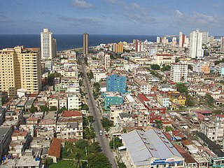
Havana is the capital and largest city of Cuba. The heart of the La Habana Province, Havana is the country's main port and commercial center. It is the most populous city, the largest by area, and the second largest metropolitan area in the Caribbean region. The population in 2012 was 2,154,454 inhabitants, and its area is 728.26 km2 (281.18 sq mi) for the capital city side and 8,475.57 km2 for the metropolitan zone.
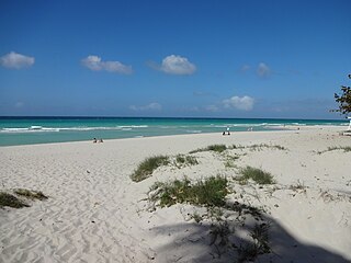
Varadero, also referred to as Playa Azul, is a resort town in the province of Matanzas, Cuba, and one of the largest resort areas in the Caribbean. Varadero Beach is rated one of the world's best beaches in TripAdvisor's Traveler's Choice Awards since 2019, ranking at number 9 as of January 2024. Common activities include fishing and excursions to Matanzas, Cárdenas, and the Península de Zapata.
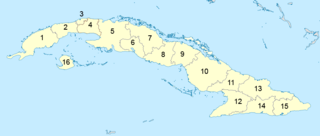
Administratively, Cuba is divided into 15 provinces and one special municipality. The current structure has been in place since August 2010, when the then-La Habana Province was divided into Artemisa Province and Mayabeque Province.

La Habana Province, formerly known as Ciudad de La Habana Province, is a province of Cuba that includes the territory of the city of Havana, the Republic's capital. The province's territory is the seat of the superior organs of the state and its provincial administration.

Villa Clara is one of the provinces of Cuba. It is located in the central region of the island bordering on the Atlantic Ocean to the north, Matanzas Province to the west, Sancti Spiritus Province to the east, and Cienfuegos Province to the South. Villa Clara shares with Cienfuegos and Sancti Spiritus on the south the Escambray Mountain Range. Its main cities are Santa Clara, Remedios, Sagua La Grande, Camajuani, Caibarién, Ranchuelo, Placetas, and Manicaragua.

The Pinar del Río Province is one of the 15 provinces of Cuba. It is at the western end of the island of Cuba. The capital and largest city is Pinar del Río.

Santa María del Mar is a sandy beach located 20 km (12 mi) east of Havana, Cuba along the Via Blanca highway.

Guanabacoa is a colonial township in eastern Havana, Cuba, and one of the 15 municipalities of the city. It is famous for its historical Santería and is home to the first African Cabildo in Havana. Guanabacoa was briefly the capital of Cuba in 1555 after Havana was attacked by French pirate Jacques de Sores. This gave rise to the Cuban saying “Like putting Havana in Guanabacoa,” which is used to describe trying to fit something too large into a space too small. Guanabacoa was the site of the Battle of Guanabacoa, a skirmish between British and Spanish troops as part of the larger Battle of Havana during the Seven Years' War.

Santa Cruz del Norte is a town and municipality in the Mayabeque Province of Cuba. Before 2011 it was part of La Habana Province. It is located on the north shore, between the cities of Havana and Matanzas, at the mouth of the Santa Cruz River.
Tarará is a gated resort town in the municipality of Habana del Este in the city of Havana, Cuba. It is about 19 km east of the city centre and west of other beaches including Santa Maria del Mar and Guanabo.

Playa is a Cuban municipality, located in the Havana province. It covers an area of 36.8 square kilometers, which makes up 8.95% of the provincial extension.

Guanabo is a beach town in the Ciudad de la Habana Province of Cuba. It is a ward located within the municipality of Habana del Este halfway between the centre of Havana and Santa Cruz del Norte, at the mouth of the Guanabo River, between the Atlantic Ocean coast and the Sierra del Canchón.

Jaruco is a municipality and town in the Mayabeque Province of Cuba.

Old Havana is the city-center (downtown) and one of the 15 municipalities forming Havana, Cuba. It has the second highest population density in the city and contains the core of the original city of Havana. The positions of the original Havana city walls are the modern boundaries of Old Havana.

Centro Habana is one of the 15 municipalities or boroughs in the city of Havana, Cuba. A chinatown - Barrio Chino - is also located in this district. It is a smaller municipality of Havana, and it has the highest population density.

Vía Blanca (I-3) is a highway in northern Cuba, connecting the capital city of Havana and the city of Matanzas. A second section extends eastwards from Matanzas to the tourist town of Varadero and to Cárdenas. Even if it is a motorway (autopista), it is part of the national highway named "Circuito Norte" (CN).
For the film see Alamar (film)
The following is an alphabetical list of topics related to Cuba.

The Hershey Electric Railway, also known as the Hershey Railway, is a standard-gauge electric interurban railway that runs from Casablanca, Havana, to the city of Matanzas, approximately 92 kilometres (57 mi) to the east. There are a number of intermediate halts and a station and depot at the town of Camilo Cienfuegos, better known by its pre-revolutionary name of Hershey. The railway is the only surviving electric line in Cuba. The railway was built by The Hershey Company to transport sugar to the port of Havana. The original electric interurban cars were bought from the JG Brill Company, but these were replaced by 60-year old cars from the Ferrocarrils de la Generalitat de Catalunya in the 1990s.
The following is a timeline of the history of Havana, Cuba.


