Miramar, Havana

Last updated
Miramar District
Flag of Cuba.svg
Distrito del Miramar
Quinta avenida.jpg
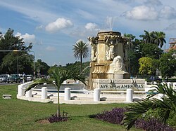
Avenida de las Americas / Carretera a el Aeropuerto Internacional de la Habana
Nickname: 
Miramar
Havana Map - Miramar (Playa).png
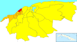
Location of Miramar in Havana
CountryFlag of Cuba.svg  Cuba
Province Havana
Municipality Playa
Elevation
45 m (148 ft)
Population
472,569
Time zone EST
Area code (+53) 7
The Russian embassy in Miramar Russian Embassy in Havana, Cuba (2011).jpg
The Russian embassy in Miramar
Playa La Concha OldYachtClubMiramarSchediwy2002.JPG
Playa La Concha
The church "Jesus de Miramar" on Quinta Avenida in Miramar Iglesia en Miramar.JPG
The church "Jesus de Miramar" on Quinta Avenida in Miramar

Miramar is a residential district (zona residencial) of the municipality of Playa, in the city of Havana.

Contents

Overview

Many embassies, including the landmark Russian Embassy, are located in Miramar - in particular on Quinta Avenida (Fifth Avenue) before called Avenida de las Américas (Avenue of the Americas).

Prior to the Revolution, the neighborhood was home to many of Havana's upscale residents. There are many large houses and mansions here. This district and the Country Club (Cubanacán) were the most glamorous spaces in the Havana of the 50s. There are also some of Havana's more modern hotels, such as Hotel Melia Habana, Oasis Panorama Hotel and Occidental Miramar, beaches and private rental houses (known as casas particulares ). Also located here is the International School of Havana.

Since the late 1990s, several office blocks have been built in a complex called Centro de Negocios Miramar - the "Miramar Trade Center".

Points of interest

Quinta Avenida (Fifth Avenue)

Parks

Education

The International School of Havana, an English-language international school, is in Miramar. [1]

The Centro Educativo Español de La Habana (CEEH), a Spanish-language international school, is in Miramar. [2]

Notable people

Related Research Articles

<span class="mw-page-title-main">Havana</span> Capital and largest city of Cuba

Havana is the capital and largest city of Cuba. The heart of the La Habana Province, Havana is the country's main port and commercial center. The city has a population of 2.3 million inhabitants, and it spans a total of 728.26 km2 (281.18 sq mi)for the Capital City side and 8,475.57 km² for the Metropolitan zone – making it the largest city by area, the most populous city, and the Second largest metropolitan area in the Caribbean region.

<span class="mw-page-title-main">Hotel Sevilla</span> Historic hotel in Havana, Cuba

The Hotel Sevilla is a historic hotel in Havana, Cuba.

<span class="mw-page-title-main">Vedado</span> Urban neighborhood in the city of Havana, Cuba

Vedado is a central business district and urban neighborhood in the city of Havana, Cuba. Bordered on the east by Calzada de Infanta and Central Havana, and on the west by the Alemendares River and Miramar / Playa district, Vedado is a more modern part of the city than the areas to the east, developed in the first half of the 20th century, during the Republic period. In 2016 it was described by one commentator as the city's "most affluent" section. The main street running east to west is Calle 23, also known as "La Rampa". The northern edge of the district is the waterfront seawall known as the Malecón, a famous and popular place for social gatherings in the city. The area popularly referred to as 'Vedado' consists of the wards of Vedado, Rampa, Vedado-Malecón and Carmelo, all in the municipality of Plaza de la Revolución.

<span class="mw-page-title-main">Playa, Havana</span> Municipality of Havana in Ciudad de La Habana, Cuba

Playa is a Cuban municipality, located in the Havana province. It covers an area of 36.8 square kilometers, which makes up 8.95% of the provincial extension.

<span class="mw-page-title-main">Malecón, Havana</span> Broad esplanade, roadway and seawall in Havana, Cuba

The Malecón is a broad esplanade, roadway, and seawall that stretches for 8 km along the coast in Havana, Cuba, from the mouth of Havana Harbor in Old Havana, along the north side of the Centro Habana neighborhood and the Vedado neighborhood, ending at the mouth of the Almendares River. New businesses are appearing on the esplanade due to economic reforms in Cuba that now allow Cubans to own private businesses.

<span class="mw-page-title-main">Roman Catholic Archdiocese of San Cristóbal de la Habana</span> Latin Catholic archdiocese in Cuba

The Archdiocese of San Cristóbal de la Habana is one of three Catholic archdioceses in Cuba.

<span class="mw-page-title-main">Iglesia de Jesús de Miramar</span>

Iglesia de Jesús de Miramar is the second largest church in Cuba. It is located in the Roman Catholic Archdiocese of San Cristobal de la Habana.

<span class="mw-page-title-main">Leonardo Morales y Pedroso</span> Cuban architect

Leonardo Morales y Pedroso was one of the most prominent Cuban architect in Cuba in the first half 20th century. In 1900 he entered and attended pre-university studies at De Witt Clinton High of New York, where he obtained a bachelor's degree. In 1909 he graduated of Bachelor in Architecture from Columbia University. After graduating, he returned to Cuba in 1909 where he worked a time in the local architect firm of Newton & Sola with the architect Thomas M. Newton, who was director of the civil construction section of the Secretary of Public Works during the 2nd American intervention in Cuba. In February 1910, he returned to the United States and obtained a master's degree (Doctor) in Architecture from Columbia University in the State of New York. After obtaining his doctorate in architecture he joined in March 1910 the architecture Company Morales y Mata arquitectos, created in 1907 by his elder brother the engineer Luis Morales y Pedroso in association with the master builder Jose F. Mata. In 1917, after having built more than 30 important buildings, they decided to separate from José Mata, who had to stop working because illness and died a short time later. The company changed its name for Morales y Compañia Arquitectos with his brother the engineer Luis Morales y Pedroso as president and Leonardo as Associate together with other 7 architects. He was able to obtain noteworthy real estate commissions partly because of his family's origin, good social connections and social standing in Havana high society. He was named by the Cuban press of the time as the "Havana's architect" and his architectural style is recognized as the "Morales style". During 50 years Leonardo Morales y Pedroso received around 250 notable architectural commissions, some of them include:

Eliseo Valdés Erustes is a Cuban artist specializing in sculpture, painting, and drawing.

<span class="mw-page-title-main">Paseo del Prado, Havana</span> Promenade in Havana, Cuba

Paseo del Prado is a street and promenade in Havana, Cuba, near the location of the old city wall, and the division between Centro Habana and Old Havana. Technically, the Paseo del Prado includes the entire length of Paseo Martí approximately from the Malecon to Calle Máximo Gómez, the Fuente de la India fountain. The promenade has had several names; it was renamed Paseo de Martí in 1898 with the island's independence from Spain. Despite the historic references, the people of Havana simply call it "El Prado".

<span class="mw-page-title-main">Carrera Séptima</span> Transit artery in Bogotá, Colombia

Carrera Séptima, also known as Eduardo Posada Flórez Avenue, is one of the principal transit arteries which crosses the eastern side of Bogotá north and south. It is the most important thoroughfare of the city in the sense of history, culture, economy, and society. Carrera Séptima is bound to the east by the Eastern Hills.

Centro Educativo Español de La Habana (CEEH) is a private Spanish curriculum, Spanish-language international school in Havana, Cuba. It consists of two campuses, a nursery through primary campus and a secondary campus, in Miramar, Playa. These campuses are less than 3 kilometres (1.9 mi) apart.

<span class="mw-page-title-main">Cayo Hueso, Havana</span> Ward of Havana in Ciudad de La Habana, Cuba

Cayo Hueso is a consejo popular (ward) in the municipality of Centro Habana, Havana, Cuba. A traditionally working-class neighborhood populated by Afro-Cubans, it is known for its many cultural landmarks such as the Callejón de Hamel, the Fragua Martiana Museum and the Parque de los Mártires Universitarios.

<span class="mw-page-title-main">Hospital de San Lázaro, Havana</span> Hospital in Havana, Cuba

Hospital de San Lázaro was a hospital in the city of Havana, Cuba. It dates back to the 17th century, when it served as headquarters for some huts built near the Caleta de Juan Guillén, then known as Caleta de San Lázaro, in an area about a mile outside the city walls.

<span class="mw-page-title-main">Barrio de San Lázaro, Havana</span> Neighborhood in Havana, Cuba

Barrio de San Lázaro is one of the first neighbourhoods in Havana, Cuba. It initially occupied the area bounded by Calle Infanta to the west, Calle Zanja to the south, Calle Belascoáin to the east, and the Gulf of Mexico to the north, forming the western edge of Centro Habana. According to the 1855 Ordenanzas Municipales of the city of Havana, Barrio San Lázaro was the Tercer Distrito and was Barrio No. 8.

<span class="mw-page-title-main">Mario Romañach</span> Cuban architect

Mario Romañach (1917–1984) was a Cuban modernist architect, planner, and university professor.

<span class="mw-page-title-main">Paseo de Tacón</span> Promenade in Ciudad de La Habana, Cuba

The Paseo de Tacón, or Paseo Militar, was created by the Captain General Miguel Tacón y Rosique (1834–1838) who promoted the reform of the “road” that, starting from the calles of San Luis de Gonzaga (Reina) and Belascoáin, connected to the Castillo del Príncipe. Calle Belascoáin was the edge between the city and the countryside.

<span class="mw-page-title-main">Calle Zulueta, Havana</span>

Calle Zulueta follows the exterior line of the old defense wall of Havana, its route is affected by several inflections along the way. Running from its northern source at Calle Arsenal, it follows a slight incline to the southwest and heads south at the intersection with Calle Neptuno, then inclining to the south southeast at Calle Dragones. With a slight incline to the southwest, it heads south at the intersection with Calle Neptuno, then inclining to the south southeast at Calle Dragones. It marks one of the limits of the Parque Central, it extends by the Plaza hotel, and by the Museo Nacional de Bellas Artes, Sloppy Joe's bar.

<span class="mw-page-title-main">Embassy of Peru, Havana</span> Peruvian diplomatic mission in Cuba

The embassy of Peru in Cuba represents the permanent diplomatic mission of the South American country in Cuba.

References

  1. "Contact Us Archived 2005-11-25 at the Wayback Machine ." International School of Havana. Retrieved on September 29, 2015. "Address: Calle 18 #315 esquina a 5ta. Avenida, Miramar, Havana. Cuba"
  2. "BIENVENIDO a nuestro Centro." Centro Educativo Español de La Habana. Retrieved on September 29, 2015. "nuestros alumnos son hijos de empresarios, diplomáticos, extranjeros residentes y ciudadanos españoles residentes en esta ciudad." and "Sede de E. Infantil y E. Primaria Avenida 5taB y 70, No. 6815 Miramar, Playa. La Habana"

23°7′21″N82°25′10″W / 23.12250°N 82.41944°W / 23.12250; -82.41944 (Miramar)