Archaeoastronomy is the interdisciplinary or multidisciplinary study of how people in the past "have understood the phenomena in the sky, how they used these phenomena and what role the sky played in their cultures". Clive Ruggles argues it is misleading to consider archaeoastronomy to be the study of ancient astronomy, as modern astronomy is a scientific discipline, while archaeoastronomy considers symbolically rich cultural interpretations of phenomena in the sky by other cultures. It is often twinned with ethnoastronomy, the anthropological study of skywatching in contemporary societies. Archaeoastronomy is also closely associated with historical astronomy, the use of historical records of heavenly events to answer astronomical problems and the history of astronomy, which uses written records to evaluate past astronomical practice.

The Goseck Circle is a Neolithic structure in Goseck in the Burgenlandkreis district in Saxony-Anhalt, Germany.
Taosi is an archaeological site in Xiangfen County, Shanxi, China. Taosi is considered to be part of the late phase of the Longshan culture in southern Shanxi, also known as the Taosi phase.
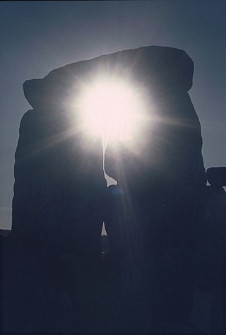
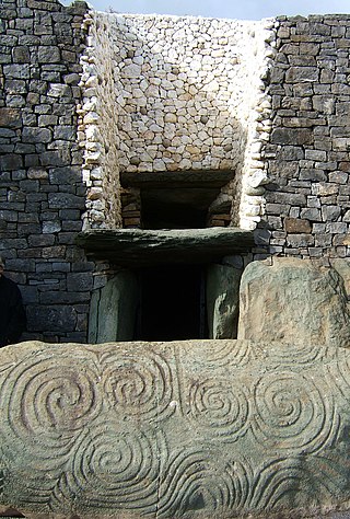
The prehistoric monument of Stonehenge has long been studied for its possible connections with ancient astronomy. The site is aligned in the direction of the sunrise of the summer solstice and the sunset of the winter solstice, and its latitude in respect to the Great Pyramid and Equator is precisely defined by the silver ratio. Archaeoastronomers have made a range of further claims about the site's connection to astronomy, its meaning, and its use.

Kokino is a Bronze Age archaeological site in the Republic of North Macedonia, approximately 30 km from the town of Kumanovo, and about 6 km from the Serbian border, in the Staro Nagoričane Municipality. It is situated between about 1010 and 1030 m above sea level on the Tatićev Kamen summit and covers an area of about 90 by 50 meters, overlooking the eponymous hamlet of Kokino.
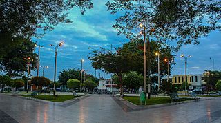
Casma is a city in the coastal desert of Peru, located 330 kilometers (210 mi) northwest of Lima. It is the capital of Casma Province and the third most populous city in the Ancash Region with an estimated population of 29,343 (2015). It is located in the lower Casma Valley, covering an area of 1,205 km2.
Buena Vista is an 8 hectare archaeological site located in Peru about 25 miles inland in the Chillon River Valley and an hour's drive north of Lima, the capital. It is in the Santa Rosa de Quives District, Canta Province, in the foothills of the Andes. The site was first excavated by Frederic Engel (1987). He obtained radiocarbon dates of artifacts that pertained to the Early Preceramic Period, and to the Early Intermediate Period.

Carahunge, also known as Zorats Karer, Dik-Dik Karer, Tsits Karer and Karenish (Քարենիշ), is a prehistoric archaeological site near the town of Sisian in the Syunik Province of Armenia. It is also often referred to among international tourists as the "Armenian Stonehenge".

The Casma River, which upstream is called Río Grande, is a river that crosses northern Casma province in the Ancash Region of Peru. It originates in the Black Mountain Range and drains into the Pacific Ocean. Major tributaries include the Sechín River (right).
The Sechín River is a seasonal river about 55 km (34 mi) long in the Ancash department of Peru that remains dry for long seasons, increasing its volume at times of rain in the mountains at its source. It is of irregular regime, due to this is known as Loco River. It rises at an altitude of 4,385 m (14,386 ft) in the Cordillera Negra and it ends by flowing into the Casma River about 10 km (6.2 mi) inland from the Pacific Ocean. The Casma-Sechin basin runs down the western slopes of the Andes mountain range - one of the world’s driest deserts. The city of Casma, population 30,000, is located near the junction of the two rivers. The Pan-American Highway crosses the Sechin River at Casma.

Mojeque, or Pampa de las Llamas-Moxeke, is a large archaeological site located in the Casma Province of Ancash Region in northern Peru. Archaeologists believe it functioned as a temple or religious structure. It contains two large mounds, many smaller mounds, and multiple human figures and heads believes to depict deities or divine rulers. Large crowds would gather at this site to observe and participate in rituals or ceremonies associated with the mounds. It is only one of the large sites of the Casma/Sechin culture in the Casma and Sechin River valleys. The others are Cerro Sechin, Sechin Alto, and Sechin Bajo. The Sechin River is a tributary of the Casma River.

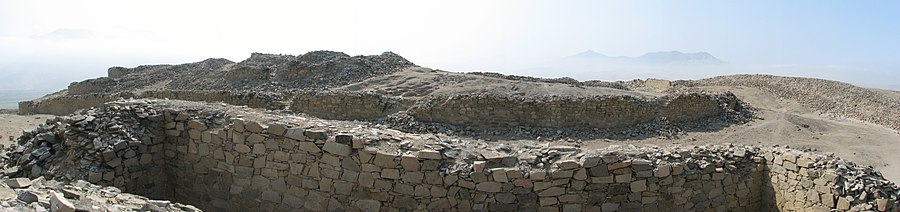
Cerro Sechín is an archaeological site in Casma Province of Ancash Region in northern Peru. Dating to 1600 BC, the site was discovered by Peruvian archaeologists Julio C. Tello and Toribio Mejía Xesspe on July 1, 1937. Tello believed it was the capital of an entire culture, now known as the Casma/Sechin culture or Sechin complex. Notable features include megalithic architecture with carved figures in bas-relief, which graphically dramatize human sacrifices. Cerro Sechín is situated within the Sechin Alto Complex, as are Sechin Bajo, and Taukachi-Konkan. There is a small on-site museum. The slabs at Cerro Sechin may represent the central Andes' oldest known monumental sculpture.
Clive L. N. Ruggles is a British astronomer, archaeologist and academic. He is the author of academic and popular works on the subject. In 1999, he was appointed professor of archaeoastronomy at the School of Archaeology and Ancient History, University of Leicester, when it is believed to have been the only appointed chair for archaeoastronomy among the world's universities. As of 2023, he was Emeritus Professor at this university.

Wurdi Youang is the name attributed to an Aboriginal stone arrangement located off the Little River – Ripley Road at Mount Rothwell, near Little River, Victoria in Australia. The site was acquired by the Indigenous Land Corporation on 14 January 2000 and transferred to the Wathaurong Aboriginal Co-operative on 17 August 2006.
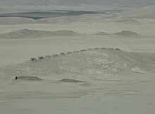
Sechin Bajo is a large archaeological site with ruins dating from 3500 BCE to 1300 BCE, making it not only one of the oldest centers of civilization in the Western Hemisphere, but also one of the oldest civilization centers on earth. Sechin Bajo is located in the valley of the Sechin River, about 12 kilometres (7.5 mi) from the Pacific Ocean and about 330 kilometres (210 mi) northwest of Lima, Peru. Sechin Bajo is one ruin among many located in close proximity to each other in the valleys of the Casma and Sechin Rivers.
Sechin Alto is a massive architectural complex in Peru belonging to the Early Formative period. It is located in the Casma Province, the Ancash Region, on the left bank of the Sechín River, east of the town of the same name. Other important archaeological sites such as Cerro Sechin and Sechin Bajo are located nearby.
Caballo Muerto is an archaeological complex located on the northern coast of Peru, in the Moche Valley, in the Laredo District of La Libertad Region. It represents a series of mound sites that span both the Initial Period and the Early Horizon.

Las Haldas or Las Aldas is a large archaeological complex from before and during the initial ceramic period of Peru. Las Haldas is located on the Pacific coast approximately 300 kilometres (190 mi) north of Lima and about 20 kilometres (12 mi) south of the Casma river valley, noted for the extensive ruins of the Casma–Sechin culture. For most of its history Las Haldas, a coastal community, coexisted with the inland agricultural communities in the Casma River Valley.

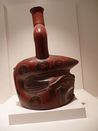
The Casma–Sechin culture of Peru refers to the large concentration of pre-historic ruins in the valleys of the Casma River and its tributary the Sechin River and along the nearby coast of the Pacific Ocean. The ruins include major archaeological sites such as Sechin Bajo, Sechin Alto, Cerro Sechin, Mojeque, Chankillo, and Taukachi-Konkan, as well as other smaller sites. Most of these inland sites are found in the river valleys about 20 kilometres (12 mi) distant from the ocean. The seaside sites of Huaynuná and Las Haldas are found about 20 kilometres (12 mi) north and south of the mouth of the Casma River on the coast.
