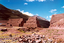
Rumicolca

Last updated
Rumicolca
Rumicolca.jpg
View of Rumicolca
Peru physical map.svg
Archaeological site icon (red).svg
Shown within Peru
Location Lucre District, Quispicanchi Province, Cusco Region, Peru
Region Andes
Coordinates 13°37′05″S71°42′26″W / 13.61806°S 71.70722°W / -13.61806; -71.70722 Coordinates: 13°37′05″S71°42′26″W / 13.61806°S 71.70722°W / -13.61806; -71.70722

Rumicolca [1] [2] (possibly from Quechua rumi stone, qullqa, qulqa deposit, storehouse) [3] is an archaeological site in Peru. It is located in the Cusco Region, Quispicanchi Province, Lucre District. Rumicolca is situated near the archaeological sites Chuqi Pukyu and Pikillaqta, east of Lake Huacarpay.

Contents

Theories on the origin of the Rumiqullqa Gate

Folklore

One story in Cusco folklore goes as follows: The Wari people once inhabited the city of Pikillaqta. The Wari were a pre-Inca civilization that existed from about 550 to 900 A.D., and they are known as the first state level society in the Sierra region of Peru. They were also the first to urbanize, [4] and at Pikillaqta, this created a substantial need for a steady and large supply of water. One of the great Wari leaders decided to solve this problem by creating a competition. He offered his only daughters hand in marriage to the man who could bring water to Pikillaqta. Two men wished to marry his daughter-one from Cusco and one from Puno-and so they both began to create plans for a way to bring water to the city. In the end, the man from Cusco decided to build a great canal from the Laguna de Huacarpay to Pikillaqta. In order to do this, he needed to cross a large gap, and so he built the first and largest aqueduct in ancient Peru, which still stands today. This is La Portada de Rumicolca.

The Gate Theory

This first theory held that La Portada was originally built by the Wari to serve as a gate to their area of rule. Later, the Inca built a larger gate on top of the old Wari foundations. This gate was meant to separate the four “suyus,” or regions, of the Inca Empire. Specifically, La Portada was the gate between the northern region of Cusco and the southern region of Puno. Since it was on the main highway between these two regions, travelers would have to pass through the gate and pay a toll to the Inca. This theory suggests that the Inca also modified La Portada to serve as an aqueduct. [5] This theory likely attempted to explain the fact that much of La Portada is made up of crude Wari stonework, encased by finely carved Inca stone veneer.

The Aqueduct Theory

The most current theory suggests that La Portada was originally built as an aqueduct by the Wari, just as told in the Cusco legend above. The Inca later adopted the site as part of their Empire, and made improvements to the structure. This is the most likely explanation, as the paleohydrologist Kenneth Wright states that the original structure is certainly of the Wari type, and the canal running along La Portada does not appear to be a retrofit, but part of the original structure. [6] This theory does not address whether it served as a gate or not, but since it is located on the main road from Cusco, it is likely that travelers would have passed through it. In fact, the entire purpose of building the aqueduct may have been in order to provide water to Pikillaqta without interrupting the flow of traffic along the road.
A view of the Inca stone veneer over Wari stonework and the aqueduct channel at La Portada de Rumicolca. La Portada de Rumicolca.JPG
A view of the Inca stone veneer over Wari stonework and the aqueduct channel at La Portada de Rumicolca.

Related Research Articles

Inca Empire Empire in pre-Columbian America

The Inca Empire, also known as the Incan Empire and the Inka Empire, was the largest empire in pre-Columbian America. The administrative, political and military center of the empire was in the city of Cusco. The Inca civilization arose from the Peruvian highlands sometime in the early 13th century. Its last stronghold was conquered by the Spanish in 1572.

Cusco Place in Peru

Cusco, often spelled Cuzco[ˈkusko], is a city in southeastern Peru near the Urubamba Valley of the Andes mountain range. It is the capital of the Cusco Region and of the Cusco Province. The city is the seventh most populous in Peru, and, in 2017, it had a population of 428,450. Its elevation is around 3,400 m (11,200 ft).

Machu Picchu 15th-century Inca citadel in the Peruvian Andes and UNESCO World Heritage Site

Machu Picchu is a 15th-century Inca citadel, located in the Eastern Cordillera of southern Peru, on a 2,430-metre (7,970 ft) mountain ridge. It is located in the Machupicchu District within Urubamba Province above the Sacred Valley, which is 80 kilometres (50 mi) northwest of Cuzco. The Urubamba River flows past it, cutting through the Cordillera and creating a canyon with a tropical mountain climate.

Department of Cuzco Departments of Peru

Cusco, also spelled Cuzco, is a department in Peru and is the fourth largest department in the country, after Madre de Dios, Ucayali, and Loreto. It borders the departments of Ucayali on the north; Madre de Dios and Puno on the east; Arequipa on the south; and Apurímac, Ayacucho and Junín on the west. Its capital is Cusco, the historical capital of the Inca Empire.

Department of Puno Departments of Peru

Puno is a department in southeastern Peru. It is the fifth largest department in Peru, after Cuzco, Madre de Dios, Ucayali, and Loreto It is bordered by Bolivia on the east, the departments of Madre de Dios on the north, Cusco and Arequipa on the west, Moquegua on the southwest, and Tacna on the south. Its capital is the city of Puno, which is located on Lake Titicaca in the geographical region known as the Altiplano or high sierra.

Vilcabamba, Peru

Vilcabamba, Willkapampa is often called the Lost City of the Incas. Vilcabamba means "sacred plain" in Quechua. The modern name for the Inca ruins of Vilcabamba is Espiritu Pampa. Vilcabamba is located in Echarate District of La Convención Province in the Cuzco Region of Peru.

Chachapoya culture

The Chachapoyas, also called the "Warriors of the Clouds", was a culture of the Andes living in the cloud forests of the southern part of the Department of Amazonas of present-day Peru. The Inca Empire conquered their civilization shortly before the Spanish conquest in the 16th century. At the time of the arrival of the conquistadors, the Chachapoyas were one of the many nations ruled by the Incas, although their incorporation had been difficult due to their constant resistance to Inca troops.

Coricancha

Coricancha, Koricancha, Qoricancha or Qorikancha was the most important temple in the Inca Empire. It is located in Cusco, Peru, which was the capital of the empire.

Quispicanchi Province Province in Cusco, Peru

Quispicanchi Province is one of thirteen provinces in the Cusco Region in the southern highlands of Peru.

Raqchi

Raqch'i (Quechua) is an Inca archaeological site in Peru located in the Cusco Region, Canchis Province, San Pedro District, near the populated place Raqch'i. It is 3480 meters above sea level and 110 kilometers from the city of Cuzco. It also known as the Temple of Wiracocha, one of its constituents. Both lie along the Vilcanota River. The site has experienced a recent increase in tourism in recent years, with 83,334 visitors to the site in 2006, up from 8,183 in 2000 and 452 in 1996.

The Incan aqueducts refer to any of a series of aqueducts built by the Inca people. The Inca built such structures to increase arable land and provide drinking water and baths to the population. Due to water scarcity in the Andean region, advanced water management allowed the Inca to thrive and expand along much of the coast of Peru. Such structures, some of which survive today, show the advanced hydraulic and civil engineering capabilities of the Inca.

Tambomachay

Tambomachay is an archaeological site associated with the Inca Empire, located near Cusco, Peru. An alternate Spanish name is El Baño del Inca.

Tipón

Tipón, is a sprawling early fifteenth-century Inca construction that is situated at 3,400 meters above sea level. The complex covers 239 hectares and is located 22 kilometers southeast of Cusco near the town of Tipón. It consists of wide agricultural terraces irrigated by a network of water channels fed by a natural spring. Several surrounding ruins have been excavated, and many more are visible below the soil.

Ñusta Hispana

Ñusta HispanaÑusta Ispanan, previously known as Chuquipalta is an archaeological site in Peru. It is located at Vilcabamba, La Convención Province, Cusco Region.

Wilcahuaín

Wilcahuaín, Willcahuaín, or Huilcahuaín is an archaeological site in Peru. It is located near the village of Paria, 7 km northwest of the city of Huaraz, Ancash; at an elevation of 3,400 m (11,200 ft).

Tupu Inka is an archaeological site in Peru. It is located in the Puno Region, Yunguyo Province, Unicachi District.

Mawk'allaqta, also Mawk'a Llaqta is an archaeological site in Peru. It is located in the Arequipa Region, La Unión Province, Puyca District, located about 2 kilometers from Puyca.

Machu Colca

Machu Colca, Machuqolqa or Machu Qollqa is an archaeological site in Peru. It lies in the Cusco Region, Urubamba Province, Huayllabamba District, a few minutes outside of Chinchero. Machu Colca is situated at about 3,850 metres (12,631 ft) of elevation, above the left bank of the Urubamba River, near the village of Raqch'i (Raqchi).

Inka Paqcha

Inka Paqcha is a mountain in the Andes of Peru, about 4,400 metres (14,436 ft) high. It is located in the Ayacucho Region, Lucanas Province, Carmen Salcedo District. Inka Paqcha lies northwest of Inka Pallanka where the archaeological site of Quriwayrachina is situated.

Aymara kingdoms

The Aymara kingdoms, Aymara lordships or lake kingdoms were a group of native polities that flourished towards the Late Intermediate Period, after the fall of the Tiwanaku Empire, whose societies were geographically located in the Qullaw. They were developed between 1150 and 1477, before the kingdoms disappeared due to the military conquest of the Inca Empire. But the current Aymara population is estimated at two million located in the countries of Bolivia, Peru, Chile and Argentina. They used the Aymara and Puquina languages.

References

  1. Segreda, Ricardo (2009). V!VA Travel Guides: Peru. Viva Publishing Network. p. 239. ISBN   9780979126437.
  2. Jenkins, Dilwyn (2003). The Rough Guide to Peru. Rough Guides. p. 189. ISBN   9781843530749.
  3. Teofilo Laime Ajacopa, Diccionario Bilingüe Iskay simipi yuyayk'ancha, La Paz, 2007 (Quechua-Spanish dictionary): rumi - s. Piedra.qullqa - s. Depósito de productos agrícolas construido de adobes.qullqa - s. Edificio depósito.
  4. Hirst, K. Krist. "Wari Empire". About.com: Archaeology. Retrieved 20 April 2014.
  5. Wright, Kenneth (2011). Moray: Inca Engineering Mystery. Reston, Virginia: ASCE Press. p. 51.
  6. Wright, Kenneth (2006). Tipon: Water Engineering Masterpiece of the Inca Empire. Reston, Virginia: ASCE Press. p. 101.