Chapel-en-le-Frith railway station

Last updated

20+12 miles (33.0 kilometres) south east of Manchester Piccadilly on the Buxton Line from Manchester. It was built in 1863 for the London & North Western Railway, on its line from Whaley Bridge to Buxton as an extension of the Stockport, Disley and Whaley Bridge Railway.

Contents

In 1867, the Midland Railway built a station (known as Chapel-en-le-Frith Central) on the Sheffield and Midland Railway Companies' Committee line from Millers Dale to Chinley. The town therefore had a main line connection from Manchester to London featuring expresses such as the 'Palatine' and the 'Peaks'. However, with the closure of the ex Midland route from Chinley to Rowsley to passenger traffic in 1967, Central station was closed. The Midland line is still in-situ and used for freight to and from Peak Forest.

The station is one of very few to retain its walkway to cross between platforms; most stations having had footbridges installed. The prime reason for this is the requirement to provide a vehicular crossing for those houses further up the hill which have no reliable alternative, as the very rough alternative is blocked for days during snow, and even when open requires a considerable extra distance to be covered to reach the town centre. A footbridge would therefore not be used.[ citation needed ]

The former station master's house was used as a restaurant called "Brief Encounter" but has been refurbished and is being used as a band room for Chapel-en-le-Frith Town Band. [1]

Facilities

The station is unstaffed but has a ticket machine which also allows the collection of pre-booked tickets. There are waiting shelters on both platforms and train running information is provided by automated announcements, CIS displays, timetable poster boards and a customer help point on platform 1. Step-free access is available to both sides via the foot crossing at the Whaley Bridge end of the station. [2]

Service

There is generally a half hourly service each day to Manchester Piccadilly northbound all week. A few early morning and evening peak hour trains on weekdays previously continued beyond Manchester Piccadilly to Clitheroe, Wigan North Western, Barrow-in-Furness, Blackpool North and Kirkby. [3] All southbound services terminate at Buxton. On Sundays, the service is hourly. [4]

1957 collision

Plaque commemorating John Axon and John Creamer, the two victims of the collision Plaque commemorating John Axon & John Creamer. Granpic on Flickr.jpg
Plaque commemorating John Axon and John Creamer, the two victims of the collision

The station was the site of a fatal collision in 1957 which is commemorated with a plaque at the station.

See also

Related Research Articles

<span class="mw-page-title-main">Chinley</span> Human settlement in England

Chinley is a rural village in the High Peak Borough of Derbyshire, England, with a population of 2,796 at the 2011 Census. Most of the civil parish is within the Peak District National Park. Historically, before the coming of the railway, the area was economically dominated by agriculture. Nowadays most inhabitants commute out of the village to work; accessible centres of work include Stockport, Sheffield and Manchester.

<span class="mw-page-title-main">Whatstandwell railway station</span> Railway station in Derbyshire, England

Whatstandwell railway station is a railway station owned by Network Rail and managed by East Midlands Railway. It serves the villages of Whatstandwell and Crich Carr in Derbyshire, England. The station is located on the Derwent Valley Line from Derby to Matlock.

<span class="mw-page-title-main">Matlock railway station</span> Railway station in Derbyshire, England

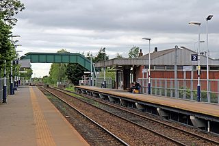
Matlock railway station is owned by Network Rail and managed by East Midlands Railway; it serves the Derbyshire Dales county town of Matlock, Derbyshire, England. The station is the terminus of both the Derwent Valley Line from Derby and Peak Rail who operate heritage services to Rowsley South. Both lines are formed from portions of the Midland Railway's former main line to Manchester Central. Through running is technically possible but is not done in normal service.

<span class="mw-page-title-main">Edale railway station</span> Railway station in Derbyshire, England

Edale railway station serves the rural village of Edale in the Derbyshire Peak District, in England. It is located 20 miles (32 km) west of Sheffield and 22 miles (35 km) east of Manchester Piccadilly. The station was opened in 1894 on the Midland Railway's Dore and Chinley line, now known as the Hope Valley Line.

<span class="mw-page-title-main">Chinley railway station</span> Railway station in Derbyshire, England

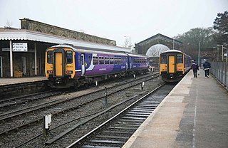
Chinley railway station serves the rural village of Chinley in Derbyshire, England. The station is 17+12 miles (28.2 km) south east of Manchester Piccadilly, on the Hope Valley Line from Sheffield to Manchester. It is unstaffed and is managed by Northern Trains.

<span class="mw-page-title-main">Bamford railway station</span> Railway station in Derbyshire, England

Bamford railway station serves the village of Bamford in the Derbyshire Peak District, in England and is managed by Northern Trains. It is located 13 miles (21 km) west of Sheffield on the Hope Valley line.

<span class="mw-page-title-main">Grindleford railway station</span> Railway station in Derbyshire, England

Grindleford railway station serves the village of Grindleford in the Derbyshire Peak District, in England, although the station is about a mile way, the nearest village being Nether Padley.

<span class="mw-page-title-main">Buxton railway station</span> Railway station in Derbyshire, England

Buxton railway station serves the Peak District town of Buxton in Derbyshire, England. It is managed and served by Northern Trains. The station is 25+34 miles (41.4 km) south east of Manchester Piccadilly and is the terminus of the Buxton line.

<span class="mw-page-title-main">Dove Holes railway station</span> Railway station in Derbyshire, England

Dove Holes railway station serves the village of Dove Holes, Derbyshire, England. The station is on the Buxton line between Manchester Piccadilly and Buxton; it is situated 22+34 miles (36.6 km) south-east of Piccadilly. It is managed and served by Northern Trains.

<span class="mw-page-title-main">Whaley Bridge railway station</span> Railway station in Derbyshire, England

Whaley Bridge railway station serves the Peak District town of Whaley Bridge in Derbyshire, England. The station is on the Manchester-Buxton Line 16+14 miles (26.2 km) south east of Manchester Piccadilly.

<span class="mw-page-title-main">Furness Vale railway station</span> Railway station in Derbyshire, England

Furness Vale railway station in Derbyshire, England, is 15+14 miles (24.5 km) south east of Manchester Piccadilly on the Manchester to Buxton line and serves the village of Furness Vale. It has a level crossing at the end of the platform controlled by a signal box.

<span class="mw-page-title-main">New Mills Newtown railway station</span> Railway station in Derbyshire, England

New Mills Newtown railway station serves the Peak District town of New Mills in Derbyshire, England. The station is 14+14 miles (22.9 km) south east of Manchester Piccadilly on the Manchester to Buxton line. It also serves as an interchange with the Hope Valley Line station New Mills Central, 15 minutes' walk away across the valley.

<span class="mw-page-title-main">Disley railway station</span> Railway station in Cheshire, England

Disley railway station serves the village of Disley in Cheshire, England. It is 12+13 miles (19.8 km) south east of Manchester Piccadilly on the Buxton Line, built by the Stockport, Disley and Whaley Bridge Railway. The station, and all trains serving it, are operated by Northern Trains.

<span class="mw-page-title-main">Middlewood railway station</span> Railway station in Greater Manchester, England

Middlewood railway station serves the village of High Lane in the Metropolitan Borough of Stockport, Greater Manchester, England.

<span class="mw-page-title-main">Hazel Grove railway station</span> Railway station in Greater Manchester, England

Hazel Grove railway station is a junction on both the Stockport to Buxton and Stockport to Sheffield lines, serving the village of Hazel Grove, Greater Manchester, England.

<span class="mw-page-title-main">New Mills Central railway station</span> Railway station in Derbyshire, England

New Mills Central railway station serves the town of New Mills in Derbyshire, England. It is on the Hope Valley Line between Manchester Piccadilly and Sheffield, 12+34 miles (20.5 km) east of the former. The town is also served by New Mills Newtown station, which is on the Buxton to Stockport and Manchester line.

<span class="mw-page-title-main">Woodsmoor railway station</span> Railway station in Greater Manchester, England

Woodsmoor railway station is on the Buxton Line in Woodsmoor, a suburb of Stockport, Greater Manchester, England. It was opened by British Rail in 1990.

<span class="mw-page-title-main">Davenport railway station (England)</span> Railway station in Greater Manchester, England

Davenport railway station serves the Davenport suburb of Stockport, Greater Manchester, England.

<span class="mw-page-title-main">Buxton line</span> Railway line in the UK

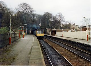
The Buxton line is a railway line in Northern England, connecting Manchester with Buxton in Derbyshire. Passenger services on the line are currently operated by Northern Trains.

<span class="mw-page-title-main">Bredbury railway station</span> Railway station in Greater Manchester, England

Bredbury railway station serves the town of Bredbury in the Metropolitan Borough of Stockport, Greater Manchester, England.

References

  1. High Peak Borough Council Licensing details, "High Peak Borough Council - Licence Details - Brief Encounter". Archived from the original on 2 January 2010. Retrieved 13 February 2010. accessed 13-102-2010
  2. Chapel-en-le-Frith station facilities National Rail Enquiries; retrieved 19 May 2017
  3. Table 82 National Rail timetable, May 2017
  4. Table 86 National Rail timetable, December 2018
Chapel-en-le-Frith
National Rail logo.svg
Chapel-en-le-Frith station.jpg
General information
Location Chapel-en-le-Frith, High Peak
England
Coordinates 53°18′43″N1°55′08″W / 53.312°N 1.919°W / 53.312; -1.919
Grid reference SK055794
Managed by Northern Trains
Platforms2
Other information
Station codeCEF
Classification DfT category F2
History
Opened1863
Passengers
2018/19Increase2.svg 67,196
Preceding station  National Rail logo.svg National Rail  Following station
Northern