Chapman's Pool

Last updated

Chapman's Pool
Chapman's Pool from Emmett's Hill.JPG
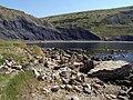
Chapman's Pool, Dorset, seen from Emmetts Hill
Dorset UK relief location map.jpg
Red pog.svg
Location in Dorset

Chapman's Pool is a small cove to the west of Worth Matravers on the Isle of Purbeck, in Dorset, England.

Contents

Geology

The rocks that form the cove are the upper parts of the Kimmeridge Clay, and are rich in fossils, especially bivalves and ammonites. Most of these fossils are flattened, but three-dimensional examples are preserved in the "Rotunda Nodules", including the age-marker ammonite, the coarse-ribbed Pavlovia rotunda.

Although manganese oxide nodules are seen, these are not local but from the cargo of the SS Treveal wrecked on the Kimmeridge Ledges below Hounstout on 10 January 1920.

Emmetts Hill Memorial

The Royal Marines memorial garden at Emmetts Hill 20160814-Royal Marines Emmetts Hill Memorial.JPG
The Royal Marines memorial garden at Emmetts Hill

The Royal Marines Association memorial garden at Emmetts Hill was initiated following the IRA attack on the Royal Marines Barracks at Deal, home and training centre for the Royal Marines Band Service, in September 1989. The originator and organiser for the project was Colin Dishington, a member of the Dorset Branch of the RMA, since renamed the Poole and District Branch. A suitable site was chosen on an exposed headland looking out over the wild seas of Kimmeridge Bay with a view down to Chapman's Pool and along the rugged Jurassic coastline to Portland. The site also overlooks a training area used by the Royal Marines both during World War II and since; in addition, it fitted the beauty and tranquility required for the memorial location. The land, which is within the boundary of the Enscombe estate, was freely given by the then owner, David Scott (Lt Col ret'd), and right of access to the site is written into the deeds of the tenant farmer. It was decided to add to the initial Deal inscription to remember Royal Marines lost in all the conflicts from 1945-1990. As well as bearing the Corps' crest, the original stone also bears a message to passing walkers and those that come to pay their respects:

Rest awhile and reflect that we who are living can enjoy the beauty of the sea and countryside.

In 2005 a new stone was added to commemorate ongoing losses of Royal Marines in current conflicts over more recent years. A service of dedication was conducted by the Rev. W. Aires, with the stone unveiled by Maj.-Gen. F. C. Barton, CB CBE RM, on 19 August 2006. Each year since the unveiling, a service has been conducted by the RMA at the memorial. The calls are sounded by a serving RM bugler from the RM Band Service. Details of the monument are registered with the Imperial War Museum's Monument section and local guides give reference to it. Access to the site is by footpath from the car park at Renscombe Farm. The original three-bar wooden rail fence has been replaced by a Purbeck stone wall to blend in with the stone walls of the area, and gives better protection to the garden, which is maintained by volunteers from the Poole and District RMA. As the site is on the main coastal path many people pause to reflect at the memorial, or use it as a resting point on their walk to enjoy the views. The ashes of RMA members have also been scattered in the monument gardens, and the families of those lost and resting elsewhere often visit the site, a truly peaceful and fitting memorial to the members of the Royal Marines family who have given their lives since WW2.

Chapman's Pool Lifeboat

In 1866, after much local pressure and because many lives were lost at sea nearby, the decision was made to build a lifeboat station at Chapman's Pool. The station was built and completed during 1867. The lifeboat George Scott was placed at Chapman's Pool in November 1866 but the station soon closed again in 1880 [1] owing to the great expense involved in up keeping the boathouse, the landslips that constantly swept down upon it and, lacking a village nearby, the dearth of local volunteers to serve on the lifeboat. The building still stands and is used as a fishing hut.

See also

Related Research Articles

Lyme Regis Coastal town in Dorset, England

Lyme Regis is a town in west Dorset, England, 25 miles (40 km) west of Dorchester and east of Exeter. Sometimes dubbed the "Pearl of Dorset", it lies by the English Channel at the Dorset–Devon border. It has noted fossils in cliffs and beaches on the Heritage or Jurassic Coast, a World Heritage Site. The harbour wall, known as The Cobb, appears in Jane Austen's novel Persuasion, the John Fowles novel The French Lieutenant's Woman and the 1981 film of that name, partly shot in the town. A former mayor and MP was Admiral Sir George Somers, who founded the English colonial settlement of Somers Isles, now Bermuda, where Lyme Regis is twinned with St George's. In July 2015, Lyme Regis joined Jamestown, Virginia in a Historic Atlantic Triangle with St George's. The 2011 Census gave the urban area a population of 4,712, estimated at 4,805 in 2019.

Jurassic Coast World Heritage Site on the coast of southern England

The Jurassic Coast is a World Heritage Site on the English Channel coast of southern England. It stretches from Exmouth in East Devon to Studland Bay in Dorset, a distance of about 96 miles (154 km), and was inscribed on the World Heritage List in mid-December 2001.

Kimmeridge Human settlement in England

Kimmeridge is a small village and civil parish on the Isle of Purbeck, a peninsula on the English Channel coast in Dorset, England. It is situated about 4.5 miles (7.2 km) south of Wareham and 7 miles (11 km) west of Swanage. In 2013 the estimated population of the civil parish was 90.

Lulworth Cove Inlet on the Jurassic Coast of Dorset, England

Lulworth Cove is a cove near the village of West Lulworth, on the Jurassic Coast in Dorset, southern England. The cove is one of the world's finest examples of such a landform, and is a World Heritage Site and tourist location with approximately 500,000 visitors every year, of whom about 30 per cent visit in July and August. It is close to the rock arch of Durdle Door and other Jurassic Coast sites.

Swanage Human settlement in England

Swanage is a coastal town and civil parish in the south east of Dorset, England. It is at the eastern end of the Isle of Purbeck and one of its two towns, approximately 6+14 miles (10 km) south of Poole and 25 miles (40 km) east of Dorchester. In the 2011 census the civil parish had a population of 9,601. Nearby are Ballard Down and Old Harry Rocks, with Studland Bay and Poole Harbour to the north. Within the parish are Durlston Bay and Durlston Country Park to the south of the town. The parish also includes the areas of Herston, just to the west of the town, and Durlston, just to the south.

Isle of Purbeck Peninsula in Dorset, England

The Isle of Purbeck is a peninsula in Dorset, England. It is bordered by water on three sides: the English Channel to the south and east, where steep cliffs fall to the sea; and by the marshy lands of the River Frome and Poole Harbour to the north. Its western boundary is less well defined, with some medieval sources placing it at Flower's Barrow above Worbarrow Bay. According to writer and broadcaster Ralph Wightman, Purbeck "is only an island if you accept the barren heaths between Arish Mell and Wareham as cutting off this corner of Dorset as effectively as the sea." The most southerly point is St Alban's Head.

Purbeck District Non-metropolitan district in England

Purbeck was a local government district in Dorset, England. The district was named after the Isle of Purbeck, a peninsula that forms a large proportion of the district's area. However, it extended significantly further north and west than the traditional boundary of the Isle of Purbeck which is the River Frome. The district council was based in the town of Wareham, which is itself north of the Frome.

Geology of Dorset

Dorset is a county in South West England on the English Channel coast. Covering an area of 2,653 square kilometres (1,024 sq mi); it borders Devon to the west, Somerset to the north-west, Wiltshire to the north-east, and Hampshire to the east. The great variation in its landscape owes much to the underlying geology, which includes an almost unbroken sequence of rocks from 200 to 40 million years ago (Mya) and superficial deposits from 2 Mya to the present. In general, the oldest rocks appear in the far west of the county, with the most recent (Eocene) in the far east. Jurassic rocks also underlie the Blackmore Vale and comprise much of the coastal cliff in the west and south of the county; although younger Cretaceous rocks crown some of the highpoints in the west, they are mainly to be found in the centre and east of the county.

Osmington Mills Human settlement in England

Osmington Mills is a coastal hamlet in the English county of Dorset. It lies within the civil parish of Osmington 5 miles (8.0 km) northeast of Weymouth.

<i>Nannopterygius</i> Extinct genus of reptiles

Nannopterygius is an extinct genus of ophthalmosaurid ichthyosaur that lived in the Middle Jurassic to the Early Cretaceous. Fossils are known from England, Russia, and Norway.

Egmont Bight

Egmont Bight is a shallow embayment at the southern end of the Encombe valley in Dorset, England. It is part of the Jurassic Coast.

Kimmeridge Bay Human settlement in England

Kimmeridge Bay is a bay on the Isle of Purbeck, a peninsula on the English Channel coast in Dorset, England, close to and southeast of the village of Kimmeridge, on the Smedmore Estate. The area is renowned for its fossils, with The Etches Collection in the village of Kimmeridge displaying fossils found by Steve Etches in the area over a 30-year period. It is a popular place to access the coast for tourists. To the east are the Kimmeridge Ledges, where fossils can be found in the flat clay beds.

Hobarrow Bay

Hobarrow Bay is a small secluded southwest-facing bay, with an oil shale and shingle beach to the southeast of Brandy Bay and to the southwest of Kimmeridge on the south coast of the Isle of Purbeck, in Dorset, England.

Kimmeridge Oil Field

The Kimmeridge Oil Field is to the northwest of Kimmeridge Bay, on the south coast of the Isle of Purbeck, in Dorset, England.

St Albans Head

St Alban's Head is a headland located 5 kilometres (3.1 mi) southwest of Swanage, on the coast of Dorset, England. It is the most southerly part of the Purbeck peninsula, and comprises an outcrop of Portland Stone from the overlying Lower Purbeck Stone. It is part of the Jurassic Coast, a World Heritage Site. It is designated a Special Area of Conservation under the European Union's Habitats Directive.

Geography of Dorset

Dorset is a county located in the middle of the south coast of England. It lies between the latitudes 50.512°N and 51.081°N and the longitudes 1.682°W and 2.958°W, and occupies an area of 2,653 km2. It spans 90 kilometres (56 mi) from east to west and 63 kilometres (39 mi) from north to south.

Cephalopod egg fossil

Cephalopod egg fossils are the fossilized remains of eggs laid by cephalopods. The fossil record of cephalopod eggs is scant since their soft, gelatinous eggs decompose quickly and have little chance to fossilize. Eggs laid by ammonoids are the best known and only a few putative examples of these have been discovered. The best preserved of these were discovered in the Jurassic Kimmeridge Clay of England. Currently no belemnoid egg fossils have ever been discovered although this may be because scientists have not properly searched for them rather than an actual absence from the fossil record.

The Etches Collection

The Etches Collection is an independent fossil museum located in the village of Kimmeridge, Purbeck, Dorset, England. It is based on the lifetime collection of Steve Etches, a fossil hunter for whom some of his finds have been named, from the local area on the Jurassic Coast, an SSI and World Heritage Site, especially around Kimmeridge Bay and the Kimmeridge Ledges.

Kimmeridge Ledges Human settlement in England

Kimmeridge Ledges is a set of Kimmeridge clay ledges stretching out in to the sea on the Isle of Purbeck, a peninsula on the English Channel coast in Dorset, England.They are located to the southeast of Kimmeridge Bay and south of the villages of Kimmeridge, on the Smedmore Estate.

References

  1. Denton, Tony (2009). Handbook 2009. Shrewsbury: Lifeboat Enthusiasts Society. p. 59.

Coordinates: 50°35′37″N2°03′52″W / 50.59348°N 2.06440°W / 50.59348; -2.06440