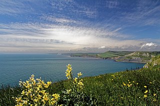
The Jurassic Coast is a World Heritage Site on the English Channel coast of southern England. It stretches from Exmouth in East Devon to Studland Bay in Dorset, a distance of about 96 miles (154 km), and was inscribed on the World Heritage List in mid-December 2001.

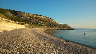
Chesil Beach in Dorset, England is one of three major shingle beach structures in Britain. Its name is derived from the Old English ceosel or cisel, meaning "gravel" or "shingle". It runs for a length of 29 kilometres (18 mi) from West Bay to the Isle of Portland and in places is up to 15 metres (50 ft) high and 200 metres (660 ft) wide. Behind the beach is the Fleet, a shallow tidal lagoon. Both are part of the Jurassic Coast and a UNESCO World Heritage Site, and together form an SSSI and Ramsar Site.
Weston is a village in Tophill on the Isle of Portland, Dorset, England. It abuts the main village Easton. As with the rest of Portland's villages and settlements, Weston has been designated as a conservation area, as it is a place of special architectural and historic interest. The village was designated in 1994.
Chesil Cove is a curved steep bank forming the south-east end of 29-kilometre (18 mi) Chesil Beach in Dorset, England. It is thus part of one of three large shingle structures in Britain, extending from West Bay to the Isle of Portland, the latter acting more firmly as a great barrier (groyne) which stops tidal action from washing the beach away and leads to the high depositions by wind and tide action forming the grand curved bank of this "cove". The "cove", bill and much of Chesil Beach give shelter from the prevailing winds and waves for much of Weymouth Bay, the town of Weymouth and the village of Chiswell. It forms part of the Jurassic Coast.

Church Ope Cove is a small secluded beach on the sheltered eastern side of the Isle of Portland in Dorset, southern England and is part of the Jurassic Coast. It is found close to the village of Wakeham. The beach has many unusual features for the Isle of Portland. The beach used to be sandy, but quarry debris now covers the sand, and has been worn into rounded pebbles. The pebbles cover a small stream which runs to the sea, which is one of the few active streams remaining on the Isle of Portland.

Pulpit Rock is a coastal feature at Portland Bill, the southern tip of the Isle of Portland, Dorset, England. Representing an open bible leaning on a pulpit, Pulpit Rock was formed in the 1870s after a natural arch was cut away by quarrymen at Bill Quarry. As a quarrying relic, the rock is similar to that of Nicodemus Knob, another quarrying landmark on the island.
Chiswell, sometimes, is a small village at the southern end of Chesil Beach, in Underhill, on the Isle of Portland in Dorset. It is the oldest settlement on the island, having formerly been known as Chesilton. The small bay at Chiswell is called Chesil Cove, and the beach promenade and sea wall which form Chiswell's coastal defences are a prominent feature.

Balaclava Bay is a bay situated on the edge of Portland Harbour, where the breakwater meets the island, at the northern end of the Isle of Portland, Dorset, in southern England. The bay is part of the Jurassic Coast, a World Heritage Site. The bay is overlooked by the Victorian East Weare Battery, built in the 1860s to protect the harbour. The nearest road within the dockyard of Portland Port is named Balaclava Road.

Tout Quarry, now known as Tout Quarry Sculpture Park and Nature Reserve, is a sculpture park and nature reserve based within a disused quarry on the Isle of Portland, Dorset, England. It is located within the north-west corner of Tophill. The sculpture park has existed since 1983, while the site also become a nature reserve around 2004. To date, the quarry displays a collection of various carvings and works in Portland stone.

The Portland Cenotaph is a war memorial located on the Isle of Portland, Dorset, England. It is situated at New Ground, looking down to Underhill of the island and overlooking Chesil Beach, as it sits in front of Portland Heights Hotel. The monument is dedicated to the local soldiers who died during both the First and Second World Wars. It has been a Grade II Listed Monument since May 1993.

The Avalanche Memorial Church, also known as the Church of St Andrew, is a Church of England church in Southwell, on the Isle of Portland, Dorset, England. It was built in 1879 and remains active as part of the Portland Parish. The church, along with its boundary wall, has been a Grade II Listed building since September 1978.

Chiswell Earthworks is a land sculpture, located on the Isle of Portland, Dorset, England. It is found above Chesil Beach's most southerly part Chesil Cove, at the end of the promenade sea wall, towards West Weares. It was created by John Maine RA, between 1986 and 1993.

The Cove House Inn is an 18th-century public house on the Isle of Portland, Dorset, England. It is situated within the village of Chiswell, and alongside Chesil Beach on the esplanade. The Cove House Inn remains one of Portland's most popular pubs, and has been reputed to be one of the best inns for panoramic views in the area. The pub has been a Grade II Listed Building since May 1993.

Freshwater Bay is a bay on the east side of the Isle of Portland, Dorset, England, south from Church Ope Cove and between the villages of Wakeham and Southwell. It forms part of the Jurassic Coast.

Culverwell Mesolithic Site is a Mesolithic settlement, located on the Isle of Portland, Dorset, England. It is found in the local area known as Culverwell, along the Portland Bill Road. It is within an area of unspoiled countryside, with no past quarrying. The site is maintained by the Association for Portland Archaeology – a small group dedicated to researching, investigating and excavating on Portland.

Portland Raised Beach refers to small raised beaches on each side of Portland Bill, on the Isle of Portland, part of the Jurassic Coast in Dorset, England. The main one is known as the West Pleistocene Raised Beach; nearby is the East Pleistocene Raised Beach.

The Great Southwell Landslip occurred in 1734 on the Isle of Portland, Dorset, England near the southerly village of Southwell and extended for a length of 1.5 miles (2.4 km) between Durdle Pier and Freshwater Bay. It remains Britain's second largest recorded historical landslide.

The Salt Pans are two salt pans on the Isle of Portland, Dorset, England. Both pans sit next to one another, and are situated on the coastline of East Weares, the east side of Portland. The pans sit directly below the Young Offenders Institution HM Prison Portland, and are found close to various old historic relics such as the East Weare Rifle Range, Folly Pier, King's Pier and the remains of the Folly Pier Waterworks. The East Weares area, including the Salt Pans, has been labelled a Site of Special Scientific Interest (SSSI), largely due to the scrub and wildlife being of high nature conservation value.

Verne Cistern is a water supply cistern on the Isle of Portland, Dorset, England. It is situated at the southern flank of the Verne Ramparts, on the slopes of Verne Hill, along the route of the horse drawn and cable operated Merchant's Railway - now a public footpath. It is on the edge of the Verne Citadel, a 19th-century fort, which is now HM Prison The Verne. The cistern became Grade II Listed in May 1993.

Victoria Square is a public square on the Isle of Portland, Dorset, England. Developed in the 19th century, it is situated at the entrance to Portland, close to Chesil Beach, Osprey Quay, and the small fishing village of Chiswell.


