
The Pinnacles are two chalk formations, including a stack and a stump, located near Handfast Point, on the Isle of Purbeck in Dorset, southern England.

The Pinnacles are two chalk formations, including a stack and a stump, located near Handfast Point, on the Isle of Purbeck in Dorset, southern England.
The Pinnacles lie directly east of Studland, approximately 200 metres south of Old Harry Rocks and about 4 kilometres northeast of Swanage. The chalk headlands of the Ballard Downs are owned by the National Trust. The rocks can be viewed from the Dorset section of the South West Coastal Path.
The downlands of Ballard Down are formed of chalk with some bands of flint, and were formed approximately 66 million years ago. The bands of stone have been gradually eroded over the centuries, some of the earlier stacks having fallen while new ones have been formed by the breaching of narrow isthmuses. [1] Across the water to the east the Needles on the Isle of Wight are usually visible. These are also part of the same chalk band and only a few thousand years ago were connected to Ballard Down.
To form the stacks, the sea gradually eroded along the joints and bedding planes where the softer chalk meets harder bedrock of the rock formations to create a cave. This eventually eroded right through to create an arch. The arch subsequently collapsed to leave the stacks called The Pinnacles.
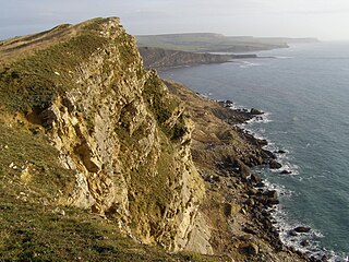
The Jurassic Coast is a World Heritage Site on the English Channel coast of southern England. It stretches from Exmouth in East Devon to Studland Bay in Dorset, a distance of about 96 miles (154 km), and was inscribed on the World Heritage List in mid-December 2001.

Studland is a village and civil parish on the Isle of Purbeck in Dorset, England. The village is located about 2 miles (3.2 km) north of the town of Swanage, over a steep chalk ridge, and 3 miles (4.8 km) south of the South East Dorset conurbation at Sandbanks, from which it is separated by Poole Harbour. The parish includes Brownsea Island within the harbour. In the 2011 census the parish had 182 households and a population of 425, though many of the houses in the village are holiday homes, second homes, or guest houses, and the village's population varies depending upon the season.

Lulworth Cove is a cove near the village of West Lulworth, on the Jurassic Coast in Dorset, southern England. The cove is one of the world's finest examples of such a landform, and is a World Heritage Site and tourist location with approximately 500,000 visitors every year, of whom about 30 per cent visit in July and August. It is close to the rock arch of Durdle Door and other Jurassic Coast sites.

The Isle of Purbeck is a peninsula in Dorset, England. It is bordered by water on three sides: the English Channel to the south and east, where steep cliffs fall to the sea; and by the marshy lands of the River Frome and Poole Harbour to the north. Its western boundary is less well defined, with some medieval sources placing it at Flower's Barrow above Worbarrow Bay. According to writer and broadcaster Ralph Wightman, Purbeck "is only an island if you accept the barren heaths between Arish Mell and Wareham as cutting off this corner of Dorset as effectively as the sea." The most southerly point is St Alban's Head.

Durdle Door is a natural limestone arch on the Jurassic Coast near Lulworth in Dorset, England. Although privately owned by the Lulworth Estate, it is open to the public.
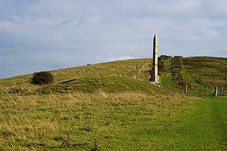
Ballard Down is an area of chalk downland on the Purbeck Hills in the English county of Dorset. The hills meet the English Channel here, and Ballard Down forms a headland, Ballard Point, between Studland Bay to the north and Swanage Bay to the south. The chalk here forms part of a system of chalk downlands in southern England, and once formed a continuous ridge between what is now west Dorset and the present day Isle of Wight. Old Harry Rocks, just offshore from the dip slope of the down, and The Needles on the westernmost tip of the Isle of Wight, are remnants of this ridge. The scarp slope of the down faces south, over Swanage, meeting the sea as Ballard Cliff.

The geology of Great Britain is renowned for its diversity. As a result of its eventful geological history, Great Britain shows a rich variety of landscapes across the constituent countries of England, Wales and Scotland. Rocks of almost all geological ages are represented at outcrop, from the Archaean onwards.

Old Harry Rocks are three chalk formations, including a stack and a stump, located at Handfast Point, on the Isle of Purbeck in Dorset, southern England. They mark the most eastern point of the Jurassic Coast, a UNESCO World Heritage Site.
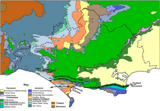
Dorset is a county in South West England on the English Channel coast. Covering an area of 2,653 square kilometres (1,024 sq mi); it borders Devon to the west, Somerset to the north-west, Wiltshire to the north-east, and Hampshire to the east. The great variation in its landscape owes much to the underlying geology, which includes an almost unbroken sequence of rocks from 200 to 40 million years ago (Mya) and superficial deposits from 2 Mya to the present. In general, the oldest rocks appear in the far west of the county, with the most recent (Eocene) in the far east. Jurassic rocks also underlie the Blackmore Vale and comprise much of the coastal cliff in the west and south of the county; although younger Cretaceous rocks crown some of the highpoints in the west, they are mainly to be found in the centre and east of the county.

The Purbeck Hills, also called the Purbeck Ridge or simply the Purbecks, are a ridge of chalk downs in Dorset, England. It is formed by the structure known as the Purbeck Monocline. The ridge extends from Lulworth Cove in the west to Old Harry Rocks in the east, where it meets the sea. The hills are part of a system of chalk downlands in southern England formed from the Chalk Group which also includes Salisbury Plain and the South Downs. For most of their length the chalk of the Purbeck Hills is protected from coastal erosion by a band of resistant Portland limestone. Where this band ends, at Durlston Head, the clay and chalk behind has been eroded, creating Poole Bay and the Solent. The ridge of steeply dipping chalk that forms the Purbeck Hills continues further east on the Isle of Wight.
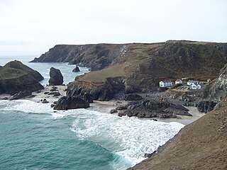
Kynance Cove is a cove on the eastern side of Mount's Bay, Cornwall, England. It is situated on the Lizard peninsula approximately two miles (3 km) north of Lizard Point. The cove became popular in the early Victorian era, with many distinguished visitors including Queen Victoria and Prince Albert and the poet Alfred Tennyson. The BBC has described Kynance Cove as "one of the most beautiful stretches of coastline in the South West". The South West Coast Path, which follows the coast of south west England from Somerset to Dorset passes by on the cliffs overlooking the cove.

Worbarrow Bay is a large broad and shallow bay just to the east of Lulworth Cove on the Isle of Purbeck, Dorset, England.

The geology of England is mainly sedimentary. The youngest rocks are in the south east around London, progressing in age in a north westerly direction. The Tees-Exe line marks the division between younger, softer and low-lying rocks in the south east and the generally older and harder rocks of the north and west which give rise to higher relief in those regions. The geology of England is recognisable in the landscape of its counties, the building materials of its towns and its regional extractive industries.

High Peak is a hill which is partially eroded, resulting in a cliff face, on the English Channel coast to the southwest of Sidmouth, Devon, southern England. Its highest point is about 157 metres (515 ft) above sea-level. It is a partially eroded Iron Age hill fort, with pre-Roman and post Roman pottery found there.

The Hampshire Basin is a geological basin of Palaeogene age in southern England, underlying parts of Hampshire, the Isle of Wight, Dorset, and Sussex. Like the London Basin to the northeast, it is filled with sands and clays of Paleocene and younger ages and it is surrounded by a broken rim of chalk hills of Cretaceous age.

Cow Corner is the north-western end of Worbarrow Bay, a small secluded bay on the south coast of the Isle of Purbeck, in Dorset England.

Parson's Barn is a large sea-level cavern below the Ballard Point cliffs, between Studland and Swanage bays in the English Channel. Ballard Point is the headland of the Ballard Downs, an area of chalk downland, on the Isle of Purbeck in Dorset, southern England.
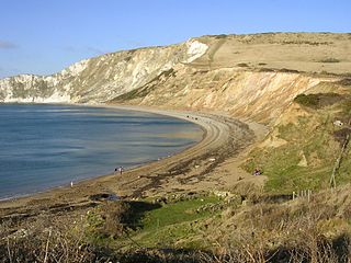
Flower’s Barrow is an Iron Age hillfort, built over 2500 years ago, above Worbarrow Bay in Dorset on the south coast of England.
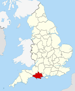
Dorset is a county located in the middle of the south coast of England. It lies between the latitudes 50.512°N and 51.081°N and the longitudes 1.682°W and 2.958°W, and occupies an area of 2,653 km2. It spans 90 kilometres (56 mi) from east to west and 63 kilometres (39 mi) from north to south.
The geology of Kent in southeast England largely consists of a succession of northward dipping late Mesozoic and Cenozoic sedimentary rocks overlain by a suite of unconsolidated deposits of more recent origin.