Charlotte Park, Florida

Last updated

Charlotte Park, Florida
Charlotte County Florida Incorporated and Unincorporated areas Charlotte Park Highlighted.svg
Location in Charlotte County and the state of Florida
Coordinates: 26°54′16″N82°2′46″W / 26.90444°N 82.04611°W / 26.90444; -82.04611
CountryFlag of the United States.svg  United States
State Flag of Florida.svg  Florida
County   Charlotte
Area
[1]
  Total1.26 sq mi (3.27 km2)
  Land1.03 sq mi (2.66 km2)
  Water0.23 sq mi (0.61 km2)
Elevation
3 ft (1 m)
Population
 (2020)
  Total2,667
  Density2,591.84/sq mi (1,001.20/km2)
Time zone UTC-5 (Eastern (EST))
  Summer (DST) UTC-4 (EDT)
ZIP code
33950 [2]
Area code 941
FIPS code 12-11650 [3]
GNIS feature ID0280328 [4]

Charlotte Park is a census-designated place (CDP) in Charlotte County, Florida, United States. The population was 2,667 at the 2020 census, up from 2,325 at the 2010 census. It is part of the Punta Gorda, Florida Metropolitan Statistical Area, included in the North Port-Bradenton, Florida Combined Statistical Area.

Contents

Geography

Charlotte Park is located next to Punta Gorda, the Charlotte County seat, at 26°54′16″N82°2′46″W / 26.90444°N 82.04611°W / 26.90444; -82.04611 (26.904421, -82.046136). [5] It is bordered by the larger city to the north, west, and south. The eastern edge of the CDP follows U.S. Route 41, the Tamiami Trail.

According to the United States Census Bureau, the CDP has a total area of 1.3 square miles (3.4 km2), of which 1.0 square mile (2.7 km2) is land and 0.27 square miles (0.7 km2), or 20.58%, is water. The CDP is crossed by several canals which lead southwest to Charlotte Harbor, an inlet of the Gulf of Mexico.

Demographics

Historical population
CensusPop.Note
1990 2,225
2000 2,182−1.9%
2010 2,3256.6%
2020 2,66714.7%
U.S. Decennial Census [6]

As of the census [3] of 2000, there were 2,182 people, 1,152 households, and 744 families residing in the CDP. The population density was 1,801.5 inhabitants per square mile (695.6/km2). There were 1,518 housing units at an average density of 1,253.3 per square mile (483.9/km2). The racial makeup of the CDP was 98.08% White, 0.27% African American, 0.09% Native American, 0.18% Asian, 0.64% from other races, and 0.73% from two or more races. Hispanic or Latino of any race were 2.15% of the population.

There were 1,152 households, out of which 7.6% had children under the age of 18 living with them, 58.2% were married couples living together, 4.6% had a female householder with no husband present, and 35.4% were non-families. 30.9% of all households were made up of individuals, and 22.2% had someone living alone who was 65 years of age or older. The average household size was 1.89 and the average family size was 2.28.

In the CDP, the population was spread out, with 7.6% under the age of 18, 3.0% from 18 to 24, 11.6% from 25 to 44, 27.4% from 45 to 64, and 50.4% who were 65 years of age or older. The median age was 65 years. For every 100 females, there were 96.4 males. For every 100 females age 18 and over, there were 94.4 males.

The median income for a household in the CDP was $29,263, and the median income for a family was $35,462. Males had a median income of $26,397 versus $25,521 for females. The per capita income for the CDP was $22,434. About 4.2% of families and 6.8% of the population were below the poverty line, including 9.4% of those under age 18 and 1.4% of those age 65 or over.

Related Research Articles

<span class="mw-page-title-main">Charlotte County, Florida</span> County in Florida, United States

Charlotte County is a U.S. county located in southwestern Florida. As of the 2020 census, the population was 186,847. Its county seat is Punta Gorda.

<span class="mw-page-title-main">Laytonville, California</span> Census-designated place in California, United States

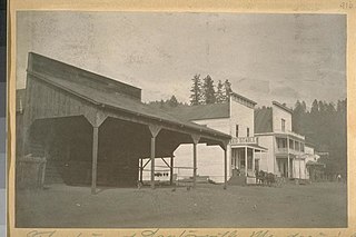
Laytonville is a census-designated place (CDP) in Mendocino County, California, United States. It is located 23 miles (37 km) north-northwest of Willits, at an elevation of 1,670 feet (510 m). The population was 1,152 at the 2020 census, down from 1,227 at the 2010 census.

<span class="mw-page-title-main">Monte Rio, California</span> Census-designated place in California, United States

Monte Rio is a census-designated place (CDP) in Sonoma County, California along the Russian River near the Pacific Ocean. The town of Guerneville lies northeast of Monte Rio, and Jenner is to the west. The population was 1,152 at the 2010 census, up from 1,104 at the 2000 census. Bohemian Grove is located in Monte Rio.

<span class="mw-page-title-main">Cleveland, Florida</span> Census-designated place in Florida, United States

Cleveland is a census-designated place (CDP) in Charlotte County, Florida, United States. The population was 3,435 at the 2020 census, up from 2,990 at the 2010 census. It is part of the Punta Gorda, FL Metropolitan Statistical Area, part of the North Port-Bradenton, Florida Combined Statistical Area.

<span class="mw-page-title-main">Grove City, Florida</span> Census-designated place in Florida, United States

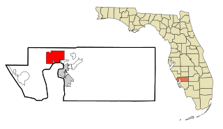
Grove City is an unincorporated community and census-designated place (CDP) in Charlotte County, Florida, United States. The population was 2,174 at the 2020 census, up from 1,804 at the 2010 census. It is part of the Punta Gorda, FL Metropolitan Statistical Area, included in the North Port-Bradenton, Florida Combined Statistical Area.

<span class="mw-page-title-main">Harbour Heights, Florida</span> Census-designated place in Florida, United States

Harbour Heights is a census-designated place (CDP) in Charlotte County, Florida, United States. The population was 3,428 at the 2020 census, up from 2,987 at the 2010 census. It is part of the Punta Gorda, Florida Metropolitan Statistical Area, included in the North Port-Bradenton, Florida Combined Statistical Area.

<span class="mw-page-title-main">Manasota Key, Florida</span> Census-designated place in Florida, United States

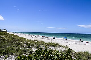
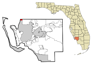
Manasota Key is a census-designated place (CDP) consisting mainly of the community of Englewood Beach in Charlotte County, Florida, United States. The population of the CDP was 1,326 at the 2020 census, up from 1,229 at the 2010 census. It is part of the Punta Gorda, Florida Metropolitan Statistical Area, included in the North Port-Bradenton, Florida Combined Statistical Area.

<span class="mw-page-title-main">Port Charlotte, Florida</span> Census-designated place in Florida, United States

Port Charlotte is an unincorporated community and census-designated place (CDP) in Charlotte County, Florida, United States. The population was 60,625 at the 2020 census, up from 54,392 at the 2010 census. It is part of the Punta Gorda, Florida Metropolitan Statistical Area, included in the North Port-Bradenton, Florida Combined Statistical Area.

<span class="mw-page-title-main">Solana, Florida</span> Census-designated place in Florida, United States

Solana is an unincorporated community and census-designated place (CDP) in Charlotte County, Florida, United States. The population was 671 at the 2020 census, down from 742 at the 2010 census. It is part of the Punta Gorda, Florida Metropolitan Statistical Area, included in the North Port-Bradenton, Florida Combined Statistical Area.

<span class="mw-page-title-main">Bokeelia, Florida</span> Census-designated place in Florida, United States

Bokeelia is an unincorporated community and census-designated place (CDP) located on Pine Island in Lee County, Florida, United States. As of the 2020 census, the CDP had a population of 1,855, up from 1,780 at the 2010 census. It is part of the Cape Coral-Fort Myers, Florida Metropolitan Statistical Area. Bokeelia is still home to one of Lee County's first pioneer families, the Padillas, who came by way of Cayo Costa.

<span class="mw-page-title-main">Burnt Store Marina, Florida</span> Census-designated place in Florida, United States

Burnt Store Marina is an unincorporated community and census-designated place (CDP) in Lee County, Florida, United States. The population was 1,890 at the 2020 census, up from 1,793 at the 2010 census. It is part of the Cape Coral-Fort Myers, Florida Metropolitan Statistical Area.

<span class="mw-page-title-main">Punta Rassa, Florida</span> Census-designated place in Florida, United States

Punta Rassa is an unincorporated community and census-designated place (CDP) in Lee County, Florida, United States. The population was 1,620 at the 2020 census, down from 1,750 at the 2010 census. It is part of the Cape Coral-Fort Myers, Florida Metropolitan Statistical Area.

<span class="mw-page-title-main">Charlotte Hall, Maryland</span> CDP in Maryland, United States

Charlotte Hall is a census-designated place (CDP) in Charles and St. Mary's counties, Maryland, United States. The population was 1,420 at the 2010 census. The Maryland Veterans Home for disabled veterans, is located on the site of the former Charlotte Hall Military Academy. The Academy site was declared the Charlotte Hall Historic District, and listed on the National Register of Historic Places in 1975. Since 1940, a sizable Amish farming community has existed nearby, along with a farmers' market and large flea market complex on Maryland Route 5, which is also the site of numerous strip-mall businesses continuing into the adjacent community of Mechanicsville. A U.S. Veterans Affairs clinic is across the highway from the Veterans Home.

<span class="mw-page-title-main">Hiller, Pennsylvania</span> Census-designated place in Pennsylvania, United States

Hiller is an unincorporated community and census-designated place in Fayette County, Pennsylvania, United States. As of the 2010 census, it had a population of 1,155, down from 1,234 at the 2000 census.

<span class="mw-page-title-main">Mountain Top, Pennsylvania</span> Census-designated place in Pennsylvania, United States

Mountain Top is an unincorporated area and census-designated place (CDP) in Luzerne County, Pennsylvania, United States. As of the 2010 census, its population was 10,982.

<span class="mw-page-title-main">Wickerham Manor-Fisher, Pennsylvania</span> Census-designated place in Pennsylvania, United States

Wickerham Manor-Fisher is a census-designated place (CDP) in Washington County, Pennsylvania, United States. The population was 1,728 at the 2010 census.

<span class="mw-page-title-main">Berea, South Carolina</span> CDP in South Carolina, United States

Berea is a census-designated place (CDP) in Greenville County, South Carolina, United States. The population was 14,295 at the 2010 census. It is part of the Greenville–Mauldin–Easley Metropolitan Statistical Area.

Wade Hampton is a census-designated place (CDP) in Greenville County, South Carolina, United States. The population was 20,622 at the 2010 census. It is named for American Civil War general and South Carolina governor Wade Hampton.

Cloverdale is a census-designated place (CDP) in southern Botetourt County, Virginia, United States. The population was 3,410 at the 2020 census. The community is located along State Route 654. It is part of the Roanoke Metropolitan Statistical Area.

Hampden is a census-designated place (CDP) consisting of the eastern portion of the town of Hampden in Penobscot County, Maine, United States. The population of the CDP was 4,343 at the 2010 census.

References

  1. "2020 U.S. Gazetteer Files". United States Census Bureau. Retrieved October 31, 2021.
  2. "Charlotte Park FL ZIP Code". zipdatamaps.com. 2023. Retrieved February 17, 2023.
  3. 1 2 "U.S. Census website". United States Census Bureau . Retrieved January 31, 2008.
  4. "US Board on Geographic Names". United States Geological Survey. October 25, 2007. Retrieved January 31, 2008.
  5. "US Gazetteer files: 2010, 2000, and 1990". United States Census Bureau. February 12, 2011. Retrieved April 23, 2011.
  6. "Census of Population and Housing". Census.gov. Retrieved June 4, 2016.