Charlotte Harbor (estuary)

Last updated
Charlotte Harbor and SW Florida in a NASA satellite image Charlotte Harbor satellite.jpg
Charlotte Harbor and SW Florida in a NASA satellite image

Charlotte Harbor Estuary, the second largest bay in Florida, is located on the Gulf of Mexico coast of west Florida with two thirds lying in Charlotte County, Florida and one in Lee County. The harbor's mouth is located behind Gasparilla Island, one of the many coastal barrier islands on the southwest coast of Florida, with access from the Gulf of Mexico through the Boca Grande Pass between Gasparilla Island on the north and Lacosta Island on the south. Charlotte Harbor covers about 270 sq mi (700 km2)

Contents

Charlotte Harbor Estuary is a natural estuary spanning the west coast of Florida from Venice to Bonita Springs on the Gulf of Mexico and is one of the most productive wetlands in Florida. [1] The estuary has a large watershed, and includes Charlotte Harbor itself as well as the Peace River, Caloosahatchee River (via Pine Island Sound) and Myakka River basins. It covers 12,653 square kilometers (4,885 sq mi), the second largest open water estuary in the state. [2]

It is classified as a bar-built estuary, formed when sandbars build up along the coastline. The sand bars block the waters behind them from the sea. Such estuaries tend to be shallow with minimal tidal action. [3]

This is a threatened ecosystem because of the rapid increase of growth and development, poor land-use policies, and the overuse of natural resources. [4] The Charlotte Harbor Aquatic Preserves, established by the state of Florida in 1975, are five contiguous aquatic preserves within the greater Charlotte Harbor estuary. It includes salt marshes, mangroves, seagrass, oyster and tidal flats. [5] It is the preserve of many species, including the American alligator, West Indian manatee, bald eagle, wood stork, piping plover, green and loggerhead sea turtles, smalltooth sawfish ( Pristis pectinata ), [6] royal false pawpaw ( Deeringothamnus pulchellus ), Florida perforate cladonia ( Cladonia perforata ), and many more. [2]

Portion of a 1901 map of Charlotte Harbor by George F. Cram 1901CharlotteHarborMap.jpg
Portion of a 1901 map of Charlotte Harbor by George F. Cram

The harbor is fed with fresh water from the Myakka River on its northwest corner and the Peace River on its northeastern corner. Charlotte Harbor is bordered by the communities of Boca Grande, Port Charlotte, Charlotte Harbor, Punta Gorda and Bokeelia. Charlotte Harbor connects to San Carlos Bay to the south by way of Pine Island Sound and Matlacha Pass.

Etymology

The name of Charlotte Harbor is a corruption of the name Calusa into the Spanish name Carlos. At the time of Spanish contact in the 1560s, the leader of the Calusa was known as Carlos. The bay was first known as Bahia Carlos, or Carlos Bay, by the Spaniards. The British changed it from Carlos to Charlotte to honor King George III's wife, Charlotte of Mecklenburg-Strelitz. [7]

History

1774 Map of Charlotte Harbor by Bernard Roman 1774mapCharlotteHarbor.jpg
1774 Map of Charlotte Harbor by Bernard Roman

Prior to the first Europeans, Charlotte Harbor was home to settlements of Native Americans who were part of the Calusa paramount chiefdom that occupied southwest Florida, extending from Tampa Bay in the north to the Ten Thousand Islands. [8] The Calusa capital of Calos was located on Mound Key, just south of Charlotte Harbor.

Early European visits

Ponce de Leon was likely the first European who visited Charlotte Harbor in 1513 and again in 1521. He and his soldiers encountered hostile Calusa, and de Leon is believed to have died from a poisoned arrow wound received there. The site of the conflict is now Ponce de Leon Historical Park in eastern Punta Gorda. [9] Charlotte Harbor might have been next visited by Juan de Anasco, Comptroller to the King of Spain, in 1538, one year before Hernando de Soto's exploration. In 1539, Hernando de Soto began his journey across the Southeast by landing on the west coast of the Florida peninsula, near the chiefdom of Uzita, where he encountered Juan Ortiz, a survivor of the Narváez expedition who had been captured by the Tocobaga at Tampa Bay. Traditional reconstructions locate Uzita at the mouth of the Manatee River in Tampa Bay, now the site of the De Soto National Memorial. [10] However, other historians believe de Soto may have entered via Charlotte Harbor as he began his exploration of North America. [11] [12] Another suggested landing site for de Soto was directly below Charlotte Harbor up within the Caloosahatchee River. [13] This is unlikely because Mound Key in Estero Bay south of the Caloosahatchee is generally agreed to have been the location of the Calusa capital, not the Uzita chiefdom.

As the Florida continued to be explored, some fisherman from Cuba and other Spanish settlements began to set up fishing camps, or "ranchos" along the Gulf Coast, including around Charlotte Harbor. [14]

The pirates and shipwrecks of Charlotte Harbor

The mythical pirate José Gaspar (also known as "Gasparilla") was said to have roamed from the Gulf of Mexico to the Spanish Main from his secret base (sometimes referred to as his "pirate kingdom") in Charlotte Harbor from the late 1700s until his death in battle with the US Navy in 1821. Though no archival or physical evidence of Gaspar's existence has ever been found, he is a popular figure in Florida folklore, and the tale of the dashing pirate and his lost treasure has been used to promote tourism in Charlotte Harbor and along Florida's Gulf coast for many years, most notably in Tampa's Gasparilla Pirate Festival. The practice began in 1900, when the Charlotte Harbor and Northern Railway published the first written account of Jose Gaspar in a promotional brochure for its Boca Grande Hotel on Gasparilla Island. [15] [16]

Charlotte Harbor is also said to have been the refuge of the pirate Brewster Baker and the site of several shipwrecks of vessels containing untold millions of Spanish gold. [17] However, despite many professional and amateur searches over the years, no treasure or evidence of a historical pirate stronghold has ever been found in the area. [18] [19]

Modern day

Charlotte Harbor as seen from Gilchrist Park in Punta Gorda Gilchrist Park Punta Gorda FL 01.jpg
Charlotte Harbor as seen from Gilchrist Park in Punta Gorda

The Charlotte Harbor of the present day is a harbor mainly for privately owned pleasure craft and fishing boats.[ citation needed ] The area thrives partly due to tourism. There are also numerous retirement communities in the Charlotte Harbor area.

Tropical cyclones

Charley making landfall on August 13, 2004 Charley Landfall.gif
Charley making landfall on August 13, 2004

Charlotte Harbor has been hit by several tropical cyclones since records began to be kept in 1851. Listed below are the tropical cyclones whose paths have crossed Charlotte Harbor. [20]

Hurricane Charley made landfall just south of Charlotte Harbor on Friday, August 13, 2004 at 3:54 PM EDT. [21] Charley had reached a maximum sustained wind speed of 150 mph (240 km/h) [22] By the time Charley reached Orlando, its winds had dropped to 95 mph (153 km/h), with gusts as high as 111 mph (179 km/h). Due to the rapid forward movement of Charley the amount of measured rainfall was between 4 and 6 inches (100 and 150 mm). [23]

On September 28, 2022, Hurricane Ian made landfall just south of Punta Gorda at Pirate Harbor. [24]

See also

Related Research Articles

<span class="mw-page-title-main">Lee County, Florida</span> County in Florida, United States

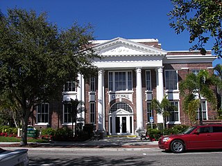
Lee County is located in southwestern Florida, United States, on the Gulf Coast. As of the 2020 census, its population was 760,822. In 2022, the population was 822,453, making it the eighth-most populous county in the state. The county seat is Fort Myers, with a population of 86,395 as of the 2020 census, and the largest city is Cape Coral, with an estimated 2020 population of 194,016.

<span class="mw-page-title-main">Captiva, Florida</span> Census-designated place in Florida, United States

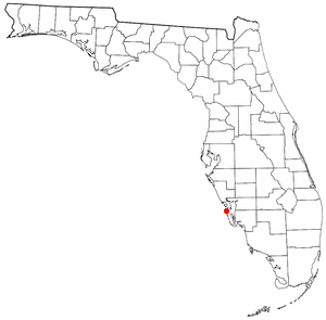
Captiva is an unincorporated community and census-designated place (CDP) in Lee County, Florida, United States. It is located on Captiva Island. As of the 2020 census, the population was 318, down from 583 at the 2010 census. It is part of the Cape Coral-Fort Myers, Florida Metropolitan Statistical Area.

The Calusa were a Native American people of Florida's southwest coast. Calusa society developed from that of archaic peoples of the Everglades region. Previous indigenous cultures had lived in the area for thousands of years.

<span class="mw-page-title-main">Boca Grande, Florida</span> Residential community in Florida, US

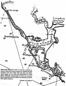
Boca Grande is a small residential community on Gasparilla Island in southwest Florida. Gasparilla Island is a part of both Charlotte and Lee counties, while the actual village of Boca Grande, which is home to many seasonal and some year-round residents, is entirely in the Lee County portion of the island. It is part of the Cape Coral-Fort Myers, Florida Metropolitan Statistical Area. Boca Grande is known for its historic downtown, sugar sand beaches, blue water and world class fishing.

<span class="mw-page-title-main">Hurricane Charley</span> Category 4 Atlantic hurricane in 2004

Hurricane Charley was the first of four separate hurricanes to impact or strike Florida during 2004, along with Frances, Ivan and Jeanne, as well as one of the strongest hurricanes ever to strike the United States. It was the third named storm, the second hurricane, and the second major hurricane of the 2004 Atlantic hurricane season. Charley lasted from August 9 to 15, and at its peak intensity it attained 150 mph (240 km/h) winds, making it a strong Category 4 hurricane on the Saffir–Simpson scale. It made landfall in Southwest Florida at maximum strength, making it the strongest hurricane to hit the United States since Hurricane Andrew struck Florida in 1992 and tied with Hurricane Ian as the strongest hurricane to hit southwest Florida in recorded history.

<span class="mw-page-title-main">Pine Island Sound</span> Coastal body of water in Florida, US

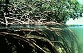
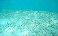
Pine Island Sound is located in Lee County, Florida, lying between Pine Island and the barrier islands of Sanibel Island, Captiva Island, North Captiva Island and Cayo Costa, which separate the Sound from the Gulf of Mexico. The Sound connects to Gasparilla Sound and Charlotte Harbor to the north, and to San Carlos Bay and the Caloosahatchee River to the south. The Sound is conterminous with the Pine Island Sound Aquatic Preserve, which was established in 1970 and consists of 54,000 acres (220 km2) of submerged land. Important habitats in the Sound include mangroves, seagrasses, salt marshes, oyster communities, tidal flats and sponge beds. All animals in and around Pine Island sound, including mollusks, fish, birds and mammals, are affected by periodic outbreaks of red tide. The Sound is relatively shallow in many locations, and boaters are cautioned to utilize up-to-date charts and tide tables.

Tocobaga was the name of a chiefdom of Native Americans, its chief, and its principal town during the 16th century. The chiefdom was centered around the northern end of Old Tampa Bay, the arm of Tampa Bay that extends between the present-day city of Tampa and northern Pinellas County. The exact location of the principal town is believed to be the archeological Safety Harbor site. This is the namesake for the Safety Harbor culture, of which the Tocobaga are the most well-known group.

<span class="mw-page-title-main">José Gaspar</span> Mythical Spanish pirate

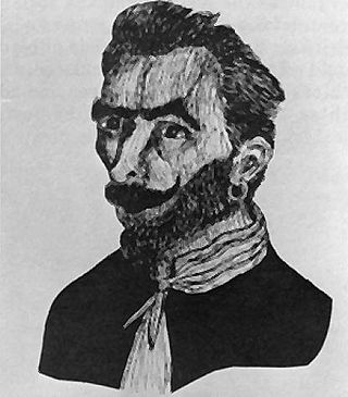
José Gaspar, also known by his nickname Gasparilla, is a fictional Spanish pirate who terrorized the Gulf of Mexico from his base in southwest Florida during Florida's second Spanish period. Though details about his early life, motivations, and piratical exploits differ in various tellings, they agree that the 'Last of the Buccaneers" was a remarkably active pirate who amassed a huge fortune by taking many prizes and ransoming many hostages during his long career and that he died by leaping from his ship rather than face capture by the U.S. Navy, leaving behind his still-hidden treasure.

<span class="mw-page-title-main">Southwest Florida</span> Region in Florida

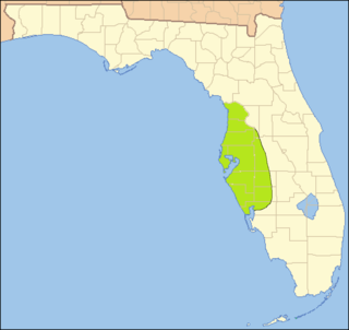
Southwest Florida is the region along the southwest Gulf coast of the U.S. state of Florida. The area is known for its beaches, subtropical landscape, and winter resort economy.

<span class="mw-page-title-main">Peace River (Florida)</span> River in the United States of America

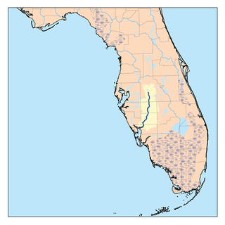
The Peace River is a river in the southwestern part of the Florida peninsula, in the U.S.A. It originates at the juncture of Saddle Creek and Peace Creek northeast of Bartow in Polk County and flows south through Fort Meade Hardee County to Arcadia in DeSoto County and then southwest into the Charlotte Harbor estuary at Punta Gorda in Charlotte County. It is 106 miles (171 km) long and has a drainage basin of 1,367 square miles (3,540 km2). U.S. Highway 17 runs near and somewhat parallel to the river for much of its course. The river was called Rio de la Paz on 16th century Spanish charts. It appeared as Peas Creek or Pease Creek on later maps. The Creek Indians call it Talakchopcohatchee, River of Long Peas. Other cities along the Peace River include Fort Meade, Wauchula and Zolfo Springs.

<span class="mw-page-title-main">Maritime history of Florida</span> History of waters in and adjacent to Florida

The maritime history of Florida describes significant past events relating to the U.S. state of Florida in areas concerning shipping, shipwrecks, and military installations and lighthouses constructed to protect or aid navigation and development of the Florida peninsula.

<span class="mw-page-title-main">Gasparilla Island</span> Barrier island in southwest Florida

Gasparilla Island is a barrier island in southwest Florida, United States, straddling the border of Charlotte and Lee counties. Its largest town is Boca Grande, and it is the location of the Gasparilla Island State Park. The island has been an important part of Florida folklore due to its connection to the pirate Gasparilla, and it has been a significant tourist destination since the early 20th century.

<span class="mw-page-title-main">Roman Catholic Diocese of Venice in Florida</span> Latin Catholic ecclesiastical jurisdiction in Florida, USA

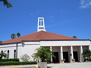
The Diocese of Venice in Florida is a Latin Church ecclesiastical territory–or diocese, of the Catholic Church in southwest Florida in the United States. It was founded on June 16, 1984.

The Caloosahatchee culture is an archaeological culture on the Gulf coast of Southwest Florida that lasted from about 500 to 1750 AD. Its territory consisted of the coast from Estero Bay to Charlotte Harbor and inland about halfway to Lake Okeechobee, approximately covering what are now Charlotte, Lee, and Collier counties. At the time of first European contact, the Caloosahatchee culture region formed the core of the Calusa domain.

Useppa Island is an island located near the northern end of Pine Island Sound in Lee County, Florida, United States. It has been known for luxury resorts since the late 19th century, and it is currently the home of the private Useppa Island Club. On May 21, 1996, it was added to the U.S. National Register of Historic Places, due to its archaeological significance.

<span class="mw-page-title-main">Punta Gorda, Florida</span> City in Florida, United States

Punta Gorda is a city located in Southwest Florida and is the county seat of Charlotte County, Florida, United States. As of the 2020 U.S. Census the city had a population of 19,471, up from 16,641 at the 2010 census. Punta Gorda is the principal city of the Punta Gorda, Florida Metropolitan Statistical Area, part of the North Port-Bradenton Florida Combined Statistical Area.

<span class="mw-page-title-main">Mocoso</span> 16th-century chiefdom in Florida

Mocoso was the name of a 16th-century chiefdom located on the east side of Tampa Bay, Florida near the mouth of the Alafia River, of its chief town and of its chief. Mocoso was also the name of a 17th-century village in the province of Acuera, a branch of the Timucua. The people of both villages are believed to have been speakers of the Timucua language.

<span class="mw-page-title-main">Safety Harbor culture</span> Archaeological culture practiced by Native Americans living on the central Gulf coast Florida

The Safety Harbor culture was an archaeological culture practiced by Native Americans living on the central Gulf coast of the Florida peninsula, from about 900 CE until after 1700. The Safety Harbor culture is defined by the presence of Safety Harbor ceramics in burial mounds. The culture is named after the Safety Harbor site, which is close to the center of the culture area. The Safety Harbor site is the probable location of the chief town of the Tocobaga, the best known of the groups practicing the Safety Harbor culture.

Pohoy was a chiefdom on the shores of Tampa Bay in present-day Florida in the late sixteenth century and all of the seventeenth century. Following slave-taking raids by people from the Lower Towns of the Muscogee Confederacy at the beginning of the eighteenth century, the surviving Pohoy people lived in several locations in peninsular Florida. The Pohoy disappeared from historical accounts after 1739.

The Charlotte Harbor and Northern Railway is a historic railroad line that at its greatest extent serviced Gasparilla Island in Charlotte Harbor and a major shipping port that once operated there. The railroad's principal purpose was to transport phosphate mined along the Peace River and in the Bone Valley region of Central Florida to the port to be shipped. It also brought passengers to the island community of Boca Grande on Gasparilla Island, and is largely responsible for making Boca Grande the popular tourist destination it is today. Part of the line remains in service today between Mulberry and Arcadia, which is now owned and operated by CSX Transportation. Today, it makes up CSX's Achan Subdivision and part of their Brewster Subdivision.

References

  1. "Charlotte Harbor Preserve State Park". floridastateparks.org. Archived from the original on 2013-02-05. Retrieved 2007-01-19.
  2. 1 2 "Charlotte Harbor". National Estuary Program. United States Environmental Protection Agency. Archived from the original on 2006-10-02. Retrieved 2007-01-19.
  3. "Bar-Built Estuary". Office of Marine Programs. University of Rhode Island. Archived from the original on 2006-09-11. Retrieved 2007-01-21.
  4. "Charlette Harbor National Estuary Program" . Retrieved 2007-01-21.
  5. "The Charlotte Harbor Aquatic Preserves". dep.state.fl.us. Archived from the original on 2007-02-06. Retrieved 2007-01-19.
  6. Poulakis, Gregg R.; Stevens, Philip W.; Timmers, Amy A.; Stafford, Christopher J.; Chapman, Demian D.; Feldheim, Kevin A.; Heupel, Michelle R.; Curtis, Caitlin (2016). "Long-term site fidelity of endangered small-tooth sawfish (Pristis pectinata) from different mothers". Fishery Bulletin. 114 (4): 461–475. doi: 10.7755/fb.114.4.8 .
  7. "Encyclopædia Britannica: Charlotte Harbor Inlet, Gulf of Mexico" . Retrieved April 28, 2009.
  8. "Historic Florida Indians by Wilkinson, Jerry" . Retrieved April 28, 2009.
  9. "Visit Florida, Charlotte Harbor Area". Archived from the original on March 31, 2009. Retrieved April 28, 2009.
  10. Hudson, Charles; Milanich, Jerald T. (1993). Hernando de Soto and the Indians of Florida. Gainesville, FL: University Press of Florida.
  11. "DeSoto's Florida Trails" . Retrieved April 28, 2009.
  12. Duncan, David Ewing (1995). Hernando de Soto, A Savage Quest for the Americas. New York, NY: Crown Publishers, Inc. pp. 255, 486–492.
  13. Schell, Rolfe F. (1966). De Soto Didn't Land at Tampa Bay. Fort Myers Beach, FL: Island Press.
  14. Hammond, E.A. (April 1973). "The Spanish Fisheries of Charlotte Harbor". The Florida Historical Quarterly. 51 (4). Retrieved 30 August 2022.
  15. Bickel, Karl A. (1942). The Mangrove Coast. Coward McCann, Inc.
  16. dAns, André-Marcel (1980). "The Legend of Gasparilla: Myth and History on Florida's West Coast". Tampa Bay History (Fall/Winter 1980). Tampa, Florida. Archived from the original on March 4, 2016. Retrieved May 20, 2012.
  17. Kaserman, James F.; Kaserman, Sarah Jane (2007). Pirates of Southwest Florida, Fact and Legend. iUniverse, Inc. pp. 16–27. ISBN   978-0595471522.
  18. Montgomery, Ben (24 January 2014). "Chasing Gaspar". The Tampa Bay Times. Retrieved 15 September 2016.
  19. Spata, Christopher (17 January 2019). "Is Gasparilla's treasure real? We went with these friends to find it". Tampa Bay Times. Retrieved 18 January 2019.
  20. "Weather Underground, Tropical Weather, Hurricane Archive: All Atlantic Storms (1851–2009)" . Retrieved April 28, 2009.
  21. "NOAA Service Assessment, Hurricane Charley August 9–15, 2004" (PDF).
  22. "NASA's Hurricane Portal, Hurricane Charley". Archived from the original on 2006-10-04. Retrieved 2016-11-03.
  23. "NWS, National Hurricane Center, Tropical Weather Summary".
  24. "NWS, National Hurricane Center, Tropical Cyclone Update".

26°46′33″N82°08′31″W / 26.77583°N 82.14194°W / 26.77583; -82.14194