San Carlos Park, Florida

Last updated

San Carlos Park, Florida
Lee County Florida Incorporated and Unincorporated areas San Carlos Park Highlighted.svg
Location in Lee County and the state of Florida
Coordinates: 26°28′28″N81°48′56″W / 26.47444°N 81.81556°W / 26.47444; -81.81556
CountryUnited States
State Flag of Florida.svg  Florida
County   Lee
Area
[1]
  Total4.97 sq mi (12.87 km2)
  Land4.72 sq mi (12.23 km2)
  Water0.24 sq mi (0.64 km2)
Elevation
16 ft (5 m)
Population
 (2020)
  Total18,563
  Density3,930.34/sq mi (1,517.58/km2)
Time zone UTC-5 (Eastern (EST))
  Summer (DST) UTC-4 (EDT)
ZIP code
33912, 33967
Area code 239
FIPS code 12-63425 [2]
GNIS feature ID0290476 [3]

San Carlos Park is a census-designated place (CDP) in Lee County, Florida, United States. The population was 18,563 at the 2020 census, up from 16,824 at the 2010 census. It is part of the Cape Coral-Fort Myers, Florida Metropolitan Statistical Area.

Contents

Geography

San Carlos Park is located in south-central Lee County at 26°28′28″N81°48′56″W / 26.47444°N 81.81556°W / 26.47444; -81.81556 (26.474458, -81.815467). [4] It is an unincorporated community, bordered to the south by the village of Estero and to the east by the Three Oaks CDP. U.S. Route 41 forms the western edge of San Carlos Park, leading north 13 miles (21 km) to Fort Myers, the county seat, and south through Estero and Bonita Springs 22 miles (35 km) to Naples.

According to the United States Census Bureau, the San Carlos Park CDP has a total area of 5.0 square miles (12.9 km2), of which 4.7 square miles (12.2 km2) are land and 0.2 square miles (0.6 km2), or 4.93%, are water. [5] The land in the CDP drains west via Mullock Creek to Estero Bay, an estuary connected to the Gulf of Mexico.

Demographics

Historical population
CensusPop.Note
1980 3,950
1990 11,785198.4%
2000 16,31738.5%
2010 16,8243.1%
2020 18,56310.3%
sources: [6] [7]

At the 2000 census there were 16,317 people, 5,901 households, and 4,449 families in the CDP. The population density was 3,360.5 inhabitants per square mile (1,297.5/km2). There were 6,580 housing units at an average density of 1,355.2 per square mile (523.2/km2). The racial makup of the CDP was 93.84% White, 1.26% African American, 0.34% Native American, 0.70% Asian, 0.01% Pacific Islander, 2.31% from other races, and 1.54% from two or more races. Hispanic or Latino of any race were 8.14%. [2]

Of the 5,901 households 42.5% had children under the age of 18 living with them, 58.2% were married couples living together, 11.3% had a female householder with no husband present, and 24.6% were non-families. 16.5% of households were one person and 4.4% were one person aged 65 or older. The average household size was 2.77 and the average family size was 3.09.

The age distribution was 29.3% under the age of 18, 6.9% from 18 to 24, 36.7% from 25 to 44, 18.5% from 45 to 64, and 8.7% 65 or older. The median age was 34 years. For every 100 females, there were 102.3 males. For every 100 females age 18 and over, there were 98.6 males.

The median household income was $45,870 and the median family income was $48,740. Males had a median income of $31,768 versus $25,541 for females. The per capita income for the CDP was $19,022. About 6.1% of families and 8.0% of the population were below the poverty line, including 8.8% of those under age 18 and 7.2% of those age 65 or over.

History

Brothers Jules & Jack Freeman established San Carlos Park in 1953 in hopes of providing low cost homes for the middle class.

The Freeman group purchased their land from the Koreshan Unity who gave them almost 250 acres for just under $3,000. When they acquired the land in Estero, Florida, they found that it was in the middle of nowhere, with the county seat, Fort Myers, Florida, being over 20 miles away.

In the 1970s, the Freeman's drilled down into the ground and hit a spring, this spring would become a local attraction located at the San Carlos Park arches

Later on in the mid-1970s the Freeman group would go on to begin construction of their next community Three Oaks, Florida.

Related Research Articles

<span class="mw-page-title-main">Bonita Springs, Florida</span> City in Florida, United States

Bonita Springs is a city in Lee County, Florida, United States. The population was 53,644 at the 2020 census, up from 43,914 at the 2010 census. It is part of the Cape Coral-Fort Myers, Florida Metropolitan Statistical Area, on the state's southwest coast.

<span class="mw-page-title-main">Buckingham, Florida</span> Census-designated place in Florida, United States

Buckingham is an unincorporated community and census-designated place (CDP) in Lee County, Florida, United States. The population was 4,443 at the 2020 census, up from 4,036 at the 2010 census. It is part of the Cape Coral-Fort Myers, Florida Metropolitan Statistical Area.

<span class="mw-page-title-main">Charleston Park, Florida</span> Census-designated place in Florida, United States

Charleston Park is an unincorporated community and census-designated place (CDP) in Lee County, Florida, United States. The population was 235 at the 2020 census, up from 218 at the 2010 census. It is part of the Cape Coral-Fort Myers, Florida Metropolitan Statistical Area.

<span class="mw-page-title-main">Cypress Lake, Florida</span> Census-designated place in Florida, United States

Cypress Lake is an unincorporated community and census-designated place (CDP) in Lee County, Florida, United States. The population was 13,727 at the 2020 census. It is part of the Cape Coral-Fort Myers, Florida Metropolitan Statistical Area.

<span class="mw-page-title-main">Estero, Florida</span> Village in Florida, United States

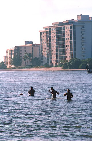
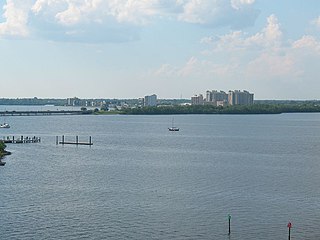
Estero is an incorporated village in Lee County, Florida, United States, located directly beside the first aquatic nature preserve established in Florida: The Estero Bay Aquatic Preserve, otherwise referred to as Estero Bay Preserve State Park which is within Estero Bay, Florida. At the time of the 2010 census, Estero was an unincorporated community and census-designated place, but incorporated as a village on the last calendar date of 2014. It is part of the Cape Coral-Fort Myers, Florida Metropolitan Statistical Area. As of the 2020 census, the population was 36,939.

<span class="mw-page-title-main">Fort Myers Beach, Florida</span> Town in Florida, United States of America

Fort Myers Beach is a town located on the North end of Estero Island in Lee County, Florida, United States. The town is on the Gulf of Mexico and is accessed from the mainland by a bridge over Estero Bay. It is part of the Cape Coral-Fort Myers, Florida Metropolitan Statistical Area. It was officially incorporated on December 31, 1995. The population was 5,582 at the 2020 census, down from 6,277 at the 2010 census.

<span class="mw-page-title-main">Fort Myers Shores, Florida</span> Census-designated place in Florida, United States

Fort Myers Shores is an unincorporated community and census-designated place (CDP) in Lee County, Florida, United States. The population was 5,774 at the 2020 census, up from 5,487 at the 2010 census. It is part of the Cape Coral-Fort Myers, Florida Metropolitan Statistical Area.

<span class="mw-page-title-main">Harlem Heights, Florida</span> Census-designated place in Florida, United States

Harlem Heights is an unincorporated community and census-designated place (CDP) in Lee County, Florida, United States. The population was 1,930 at the 2020 census, down from 1,975 at the 2010 census. It is part of the Cape Coral-Fort Myers, Florida Metropolitan Statistical Area.

<span class="mw-page-title-main">Lochmoor Waterway Estates, Florida</span> Census-designated place in Florida, United States

Lochmoor Waterway Estates is an unincorporated community and census-designated place (CDP) in Lee County, Florida, United States. The population was 5,828 at the 2020 census, up from 4,204 at the 2010 census. It is part of the Cape Coral-Fort Myers, Florida Metropolitan Statistical Area.

<span class="mw-page-title-main">McGregor, Florida</span> Census-designated place in Florida, United States

McGregor is a census-designated place (CDP) in Lee County, Florida, United States. The population was 7,976 at the 2020 census, up from 7,406 at the 2010 census. It is part of the Cape Coral-Fort Myers, Florida Metropolitan Statistical Area.

<span class="mw-page-title-main">North Fort Myers, Florida</span> Census-designated place in Florida, United States

North Fort Myers is an unincorporated area and census-designated place (CDP) in Lee County, Florida, United States. The population was 42,719 at the 2020 census, up from 39,407 at the 2010 census. It is part of the Cape Coral-Fort Myers, Florida Metropolitan Statistical Area.

<span class="mw-page-title-main">Olga, Florida</span> Census-designated place in Florida, United States

Olga is an unincorporated community and census-designated place (CDP) in Lee County, Florida, United States. The population was 2,270 at the 2020 census, up from 1,952 at the 2010 census. It is part of the Cape Coral-Fort Myers, Florida Metropolitan Statistical Area.

<span class="mw-page-title-main">Page Park, Florida</span> Census-designated place in Florida, United States

Page Park is a census-designated place (CDP) in Lee County, Florida, United States. The population was 747 at the 2020 census, up from 514 at the 2010 census. It is part of the Cape Coral-Fort Myers, Florida Metropolitan Statistical Area.

<span class="mw-page-title-main">Palmona Park, Florida</span> Census-designated place in Florida, United States

Palmona Park is a census-designated place (CDP) in Lee County, Florida, United States. The population was 1,240 at the 2020 census, down from 1,146 at the 2010 census. It is part of the Cape Coral-Fort Myers, Florida Metropolitan Statistical Area.

<span class="mw-page-title-main">St. James City, Florida</span> Census-designated place in Florida, United States

St. James City is an unincorporated community and census-designated place (CDP) on Pine Island in Lee County, Florida, United States. The population was 3,876 at the 2020 census, up from 3,784 at the 2010 census. It is part of the Cape Coral-Fort Myers, Florida Metropolitan Statistical Area.

<span class="mw-page-title-main">Three Oaks, Florida</span> Census-designated place in Florida, United States

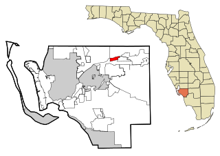
Three Oaks is a census-designated place (CDP) in Lee County, Florida, United States. The population was 5,472 at the 2020 census, up from 3,592 at the 2010 census. It is part of the Cape Coral-Fort Myers, Florida Metropolitan Statistical Area.

<span class="mw-page-title-main">Tice, Florida</span> Census-designated place in Florida, United States

Tice is an unincorporated community and census-designated place (CDP) in Lee County, Florida, United States. As of the 2020 census, the CDP population was 4,853. It is part of the Cape Coral-Fort Myers, Florida Metropolitan Statistical Area.

<span class="mw-page-title-main">Villas, Florida</span> Census-designated place in Florida, United States

Villas, Florida is an unincorporated community and census-designated place (CDP) in Lee County, Florida, United States. The population was 12,687 at the 2020 census, up from 11,569 at the 2010 census. It is part of the Cape Coral-Fort Myers, Florida Metropolitan Statistical Area.

<span class="mw-page-title-main">Whiskey Creek, Florida</span> Census-designated place in Florida, United States

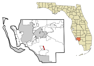
Whiskey Creek is a census-designated place (CDP) in Lee County, Florida, United States. The population was 4,842 at the 2020 census, up from 4,655 at the 2010 census. It is part of the Cape Coral-Fort Myers, Florida Metropolitan Statistical Area.

<span class="mw-page-title-main">Westchester, Florida</span> Census-designated place in Florida

Westchester is a census-designated place (CDP) and neighborhood in Miami-Dade County, Florida. It is part of the Miami metropolitan area of South Florida. Prior to the 2020 U.S. Census, the neighboring University Park CDP was merged into Westchester CDP, effectively doubling its geography and population. Per the 2020 census, the population was 56,384.

References

  1. "2020 U.S. Gazetteer Files". United States Census Bureau. Retrieved December 2, 2021.
  2. 1 2 "U.S. Census website". United States Census Bureau . Retrieved January 31, 2008.
  3. "US Board on Geographic Names". United States Geological Survey. October 25, 2007. Retrieved January 31, 2008.
  4. "US Gazetteer files: 2010, 2000, and 1990". United States Census Bureau. February 12, 2011. Retrieved April 23, 2011.
  5. "U.S. Gazetteer Files: 2019: Places: Florida". U.S. Census Bureau Geography Division. Retrieved December 4, 2019.
  6. "Profile of General Population and Housing Characteristics: 2010 Census Summary File 1 (DP-1), San Carlos Park CDP, Florida". American FactFinder. U.S. Census Bureau. Archived from the original on February 13, 2020. Retrieved December 4, 2019.
  7. "CENSUS OF POPULATION AND HOUSING (1790-2000)". U.S. Census Bureau . Retrieved July 17, 2010.