Captiva, Florida

Last updated

Captiva, Florida
Lee County Florida Incorporated and Unincorporated areas Captiva Highlighted.svg
Location in Lee County and the state of Florida
Coordinates: 26°31′5″N82°11′28″W / 26.51806°N 82.19111°W / 26.51806; -82.19111
CountryUnited States
State Flag of Florida.svg  Florida
County   Lee
Area
[1]
  Total1.64 sq mi (4.26 km2)
  Land1.18 sq mi (3.06 km2)
  Water0.46 sq mi (1.20 km2)
Elevation
7 ft (2 m)
Population
 (2020)
  Total318
  Density269.26/sq mi (103.93/km2)
Time zone UTC-5 (Eastern (EST))
  Summer (DST) UTC-4 (EDT)
ZIP code
33924
Area code 239
FIPS code 12-10425 [2]
GNIS feature ID0280017 [3]
Website sanibel-captiva.org
A flock of Royal Terns in flight above the western beach of Upper Captiva Island Captiva terns2.jpg
A flock of Royal Terns in flight above the western beach of Upper Captiva Island

Captiva is an unincorporated community and census-designated place (CDP) in Lee County, Florida, United States. It is located on Captiva Island. As of the 2020 census, the population was 318, [4] down from 583 at the 2010 census. It is part of the Cape Coral-Fort Myers, Florida Metropolitan Statistical Area.

Contents

Located just offshore in the Gulf of Mexico, the island is just north of Sanibel Island. Captiva is accessed by a small bridge that crosses Blind Pass from Sanibel Island. There is a toll to use the causeway that goes from the mainland to Sanibel Island.

Many of Captiva's homes, condominiums, and businesses were destroyed during Hurricane Charley in 2004, but the island recovered shortly thereafter. In September 2022, Hurricane Ian caused significant damage to the causeway and to the infrastructure of the island. [5]

Geography

Damage on Captiva Island from Hurricane Charley Hurricane Charley Captiva Damage.jpg
Damage on Captiva Island from Hurricane Charley

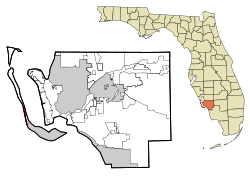
Captiva is located in western Lee County at 26°31′5″N82°11′28″W / 26.51806°N 82.19111°W / 26.51806; -82.19111 (26.518028, -82.191057). [6] The CDP comprises the entire island, bordered to the west by the Gulf of Mexico and to the east by Pine Island Sound. Captiva Drive is the main road on the island, running from the town center south to the Blind Pass bridge to Sanibel. It is a 13-mile (21 km) drive from Captiva to the Sanibel Causeway and a total of 31 miles (50 km) by road from Captiva to the center of Fort Myers.

According to the United States Census Bureau, the Captiva CDP has a total area of 1.7 square miles (4.3 km2), of which 1.2 square miles (3.1 km2) are land and 0.46 square miles (1.2 km2), or 28.15%, are water. [7]

Originally part of neighboring Sanibel Island to the southeast, it was severed in 1926 when a hurricane's storm surge created a new channel, Blind Pass. The channel filled in over subsequent years, but was reopened by dredging in the summer of 2009. Like Sanibel, Captiva is a barrier island to Pine Island (to the east of Captiva and north of Sanibel), however it is much narrower. The only automobile access to Captiva is via the Sanibel Causeway and Sanibel-Captiva Road, which ends in the CDP of Captiva, the island's only CDP. Captiva was homesteaded in 1888 and a tiny cemetery next to The Chapel by the Sea has the grave of the original resident, William Herbert Binder (1850–1932), an Austrian. Half the island is in private ownership, with "Millionaire's Row", luxury homes on the gulf and bay sides of Captiva Drive. The South Seas Island Resort entry gate is at the end of this road. Roosevelt Channel on the east side of the island, is named for Theodore Roosevelt who fished there.

North Captiva Island or Upper Captiva is another island, in turn severed from Captiva in a 1921 hurricane, creating Redfish Pass. [8] North Captiva has power from lines that originate on the north end of Captiva, and is privately owned. The island can only be accessed via boat or small plane.

Captiva was seriously damaged in August 2004 when the eastern eyewall of Hurricane Charley struck North Captiva, immediately before hitting Charlotte Harbor to the north-northeast. Initial reports indicated that 160 buildings were destroyed and another 160 seriously damaged. Reports indicate that the storm surge cut a path 491 yards (449 m) wide across the narrowest part of North Captiva, separating the island. The separation of the two halves of the island began three years earlier during a series of tornadoes caused by Tropical Storm Gabrielle that passed through the area in September 2001. [9] The new pass filled in within a few years and is now back to its pre-Charley state. Most of the invasive Australian pines on the island blew over in the hurricane, making room for native mangroves and sabal palms.

In September 2022, Category 4 Hurricane Ian made landfall in Upper Captiva with sustained winds of 150 mph. The Sanibel Causeway was heavily damaged by the hurricane.

Demographics

As of the census [2] of 2000, there were 379 people, 194 households, and 130 families residing in the CDP. The population density was 305.3 inhabitants per square mile (117.9/km2). There were 1,150 housing units at an average density of 926.2 per square mile (357.6/km2). The racial makeup of the CDP was 98.42% White, 0.79% Asian, 0.26% from other races, and 0.53% from two or more races. Hispanic or Latino of any race were 0.79% of the population.

There were 194 households, out of which 10.3% had children under the age of 18 living with them, 63.9% were married couples living together, 1.5% had a female householder with no husband present, and 32.5% were non-families. 25.3% of all households were made up of individuals, and 11.9% had someone living alone who was 65 years of age or older. The average household size was 1.95 and the average family size was 2.25.

In the CDP, the population was spread out, with 8.2% under the age of 18, 1.1% from 18 to 24, 14.2% from 25 to 44, 44.1% from 45 to 64, and 32.5% who were 65 years of age or older. The median age was 58 years. For every 100 females, there were 96.4 males. For every 100 females age 18 and over, there were 96.6 males.

The median income for a household in the CDP was $64,821, and the median income for a family was $120,488. Males had a median income of $31,875 versus $44,861 for females. The per capita income for the CDP was $76,139. None of the population or families were below the poverty line.

Historical population
CensusPop.Note
2000 379
2010 58353.8%
2020 318−45.5%
U.S. Decennial Census [10]

Economy

Plantation Rd. inside South Seas Island Resort in Captiva South Seas Island Resort, Captiva Island, Florida.jpg
Plantation Rd. inside South Seas Island Resort in Captiva

Travel, tourism and hospitality rank as the number one industry on Captiva Island (and its sister island immediately to the south, Sanibel). Noted guests to Captiva include Teddy Roosevelt, Charles Lindbergh (who regularly landed his plane on the beach in front of 'Tween Waters Inn), Anne Morrow Lindbergh and J.N. "Ding" Darling. [11] Both the Old Captiva House restaurant and a number of guest cottages have been designated historically-significant sites by Lee County, Florida.

The Bubble Room was built on Captiva Island in 1979 by the Farquharson family. It is a multi-themed restaurant featuring old toys from the 1930s and 1940s and the collection continues to grow each day. The Bubble Room plays music from the 1920s, 1930s, and 1940s. The Bubble Room was one of the first establishments on Captiva Island to originate the bright pastel colors now widely used there. [12]

South Seas Island Resort and Yacht Harbor, a 330-acre (1.3 km2) resort, occupies the northern two miles (3 km) of Captiva Island.

Pepperidge Farm created a cookie in honor of the island. It is a Dark Chocolate Brownie cookie called Captiva. [13]

The Wall Street Journal selected Sanibel and Captiva Islands as one of the 10 Best Places for Second Homes in 2010. [14]

History

According to local folklore, Captiva got its name because the pirate captain José Gaspar (Gasparilla) held his female prisoners on the island for ransom. However, the supposed existence of José Gaspar is sourced from an advertising brochure of an early 20th-century developer, and may be a fabrication.

Around 3000 B.C., the sands of Captiva started to erode, resulting in the eventual formation of Sanibel Island. The Gulf of Mexico waters were eight feet lower than they are today. It is said that the first inhabitants of Captiva were the Calusa Indians. [15] The population of the Calusa is believed to have reached as many as 50,000 people. "Calusa" means "fierce people", and they were described as a war-like people. The Calusa Indians were resistant to colonization and attacked any explorers who came into their territory. Calusa Indians built their houses on stilts without walls. They wove palmetto leaves together to build roves (twisted strands of fibers). The Calusa Indians fished for food on the coast, bays, rivers, and waterways. They did not farm. "The Calusa Indians did not farm like the other Indian tribes in Florida. Instead, they fished for food on the coast, bays, rivers, and waterways. The men and boys of the tribe made nets from palm tree webbing to catch mullet, pinfish, pigfish, and catfish. They used spears to catch eels and turtles. They made fish bone arrowheads to hunt for animals such as deer. The women and children learned to catch shellfish like conchs, crabs, clams, lobsters, and oysters." [16] The Calusa Indians used the shells on the island for utensils, jewelry, tools, weapons, and ornaments.

By the late 1700s most of the Calusa Indians had died out. Many were captured and sold as slaves while others died from diseases such as smallpox and measles.

An Austrian named Binder (b. 1850) was on a German freighter headed to New Orleans when the ship crashed and he was shipwrecked off Boca Grande. He then washed up to shore on what has been since 1921, Upper Captiva. "He lived for several weeks on what the unoccupied island had to offer, built a makeshift raft, and got himself to Pine Island, where he was helped to return to his home. By 1888, due to his having fought with the U.S. Army, he became naturalized, and was allowed to homestead on Captiva in 1888, when he was 38 years old. For 10 years he was Captiva's first and only modern-era inhabitant. He died in 1932." [17]

Notable residents

Captiva was the full-time home of artist Robert Rauschenberg. His home still stands there. [18]

Roy Lichtenstein, American pop artist, also had a home on Captiva.[ citation needed ]

In media

In the 1997 movie G.I. Jane , Captiva Island is the location for the S.E.R.E. (Survival, Evasion, Resistance, Escape) training for the fictional U.S. Navy Combined Reconnaissance Team.

In the 1986 movie Manhunter , Captiva Island is where FBI psychologist Will Graham has retired to.

Related Research Articles

<span class="mw-page-title-main">DeSoto County, Florida</span> County in Florida, United States

DeSoto County is a county located in the Florida Heartland region of the U.S. state of Florida. As of the 2020 census, the population was 33,976. Its county seat is Arcadia.

<span class="mw-page-title-main">Lee County, Florida</span> County in Florida, United States

Lee County is located in southwestern Florida, United States, on the Gulf Coast. As of the 2020 census, its population was 760,822. In 2022, the population was 822,453, making it the eighth-most populous county in the state. The county seat is Fort Myers, with a population of 86,395 as of the 2020 census, and the largest city is Cape Coral, with an estimated 2020 population of 194,016.

<span class="mw-page-title-main">Merritt Island, Florida</span> Census-designated place in Florida, United States

Merritt Island is a peninsula, commonly referred to as an island, in Brevard County, Florida, United States, located on the eastern Florida coast, along the Atlantic Ocean. It is also the name of an unincorporated town in the central and southern parts of the island and a census-designated place (CDP).

<span class="mw-page-title-main">Port Charlotte, Florida</span> Census-designated place in Florida, United States

Port Charlotte is an unincorporated community and census-designated place (CDP) in Charlotte County, Florida, United States. The population was 60,625 at the 2020 census. It is part of the Sarasota-Bradenton-Punta Gorda Combined Statistical Area.

<span class="mw-page-title-main">Bokeelia, Florida</span> Census-designated place in Florida, United States

Bokeelia is an unincorporated community and census-designated place (CDP) located on Pine Island in Lee County, Florida, United States. As of the 2020 census, the CDP had a population of 1,855, up from 1,780 at the 2010 census. It is part of the Cape Coral-Fort Myers, Florida Metropolitan Statistical Area. Bokeelia is still home to one of Lee County's first pioneer families, the Padillas, who came by way of Cayo Costa.

<span class="mw-page-title-main">Fort Myers Beach, Florida</span> Town in Florida, United States of America

Fort Myers Beach is a town located on the North end of Estero Island in Lee County, Florida, United States. The town is on the Gulf of Mexico and is accessed from the mainland by a bridge over Estero Bay. It is part of the Cape Coral-Fort Myers, Florida Metropolitan Statistical Area. It was officially incorporated on December 31, 1995. The population was 5,582 at the 2020 census.

<span class="mw-page-title-main">Iona, Florida</span> Census-designated place in Florida, United States

Iona is an unincorporated community and census-designated place (CDP) in Lee County, Florida, United States. The population was 16,908 at the 2020 census, up from 15,404 at the 2010 census. It is part of the Cape Coral-Fort Myers, Florida Metropolitan Statistical Area.

<span class="mw-page-title-main">Matlacha, Florida</span> Census-designated place in Florida, United States

Matlacha is a census-designated place (CDP) in Lee County, Florida, United States. As of the 2020 census, the CDP had a population of 598. It is part of the Cape Coral-Fort Myers, Florida Metropolitan Statistical Area.

<span class="mw-page-title-main">Pine Island Center, Florida</span> Census-designated place in Florida, United States

Pine Island Center is an unincorporated community and census-designated place (CDP) located on Pine Island in Lee County, Florida, United States. The population was 1,942 at the 2020 census. It is part of the Cape Coral-Fort Myers, Florida Metropolitan Statistical Area.

<span class="mw-page-title-main">Pineland, Florida</span> Census-designated place in Florida, United States

Pineland is an unincorporated community and census-designated place (CDP) on Pine Island in Lee County, Florida, United States. The population was 466 at the 2020 census. It is part of the Cape Coral-Fort Myers, Florida Metropolitan Statistical Area.

<span class="mw-page-title-main">Punta Rassa, Florida</span> Census-designated place in Florida, United States

Punta Rassa is an unincorporated community and census-designated place (CDP) in Lee County, Florida, United States. The population was 1,620 at the 2020 census. It is part of the Cape Coral-Fort Myers, Florida Metropolitan Statistical Area.

<span class="mw-page-title-main">Sanibel, Florida</span> City in Florida, United States of America

Sanibel is an island and city in Lee County, Florida, United States. The population was 6,382 at the 2020 census. It is part of the Cape Coral-Fort Myers, Florida Metropolitan Statistical Area. The island, also known as Sanibel Island, constitutes the entire city. It is a barrier island—a collection of sand on the leeward side of the more solid coral-rock of Pine Island.

<span class="mw-page-title-main">St. James City, Florida</span> Census-designated place in Florida, United States

St. James City is an unincorporated community and census-designated place (CDP) on Pine Island in Lee County, Florida, United States. The population was 3,876 at the 2020 census, up from 3,784 at the 2010 census. It is part of the Cape Coral-Fort Myers, Florida Metropolitan Statistical Area.

<span class="mw-page-title-main">Cortez, Florida</span> Census-designated place in Florida, United States

Cortez, a census-designated place (CDP) in Manatee County, Florida, United States, is a small Gulf Coast commercial fishing village that was founded by settlers from North Carolina in the 1880s. The population was 4,121 at the 2020 census. It is part of the Bradenton-Sarasota-Venice, Florida Metropolitan Statistical Area.

<span class="mw-page-title-main">Kendall, Florida</span> Census-designated place in Florida

Kendall is an unincorporated area and census-designated place in Miami-Dade County, Florida. It is part of the Miami metropolitan area of South Florida. At the 2020 census, the area had a population of 80,241.

<span class="mw-page-title-main">Big Pine Key, Florida</span> Census-designated place in Florida, United States

Big Pine Key is a census-designated place and unincorporated community in Monroe County, Florida, United States, on an island of the same name in the Florida Keys. As of the 2020 census, the town had a total population of 4,521.

Rock Island Arsenal is a census-designated place (CDP) in Rock Island County, Illinois, United States. The population was 149 at the 2010 census. The island contains the Rock Island National Cemetery.

Pine Island is the largest island on the Gulf Coast of peninsular Florida in the United States. Located in Lee County, on the Gulf of Mexico coast of southwest Florida, it is also the 118th largest island in the United States. The Intracoastal Waterway passes through Pine Island Sound, to the west of the island. Matlacha Pass runs between Pine Island and the mainland. Pine Island lies west of Cape Coral. For many years, Pine Island was a major commercial fishing community and many of its full-time residents still fish commercially today.

<span class="mw-page-title-main">Pine Island Sound</span> Coastal body of water in Florida, US

Pine Island Sound is located in Lee County, Florida, lying between Pine Island and the barrier islands of Sanibel Island, Captiva Island, North Captiva Island and Cayo Costa, which separate the Sound from the Gulf of Mexico. The Sound connects to Gasparilla Sound and Charlotte Harbor to the north, and to San Carlos Bay and the Caloosahatchee River to the south. The Sound is conterminous with the Pine Island Sound Aquatic Preserve, which was established in 1970 and consists of 54,000 acres (220 km2) of submerged land. Important habitats in the Sound include mangroves, seagrasses, salt marshes, oyster communities, tidal flats and sponge beds. All animals in and around Pine Island sound, including mollusks, fish, birds and mammals, are affected by periodic outbreaks of red tide. The Sound is relatively shallow in many locations, and boaters are cautioned to utilize up-to-date charts and tide tables.

<span class="mw-page-title-main">Sanibel Colored School</span> United States historic place

Sanibel Colored School, also known as Sanibel School, is a U.S. National Registered Historic school located in Sanibel, Florida. Starting all the way from 1914, schooling in Sanibel started from a Baptist church that James Johnson built on Sanibel Island. Thirteen years later, Johnson gave black families the opportunity to use the church for schooling for the children which later resulted in the Lee County Board of Public Instruction buying it for a little over $1,000. Schooling with them was a little bit different from regular schooling, because they only needed seven children in order to operate school with grades 1-8. With the population in Sanibel being 90 people, it was a little hard to keep up with the school because children were 9th-12th graders. A little after, it got to the point where the school had to close their doors. In the year of 1962, the Lee County School Board put the schools up for sale.

References

  1. "2020 U.S. Gazetteer Files". United States Census Bureau. Retrieved October 31, 2021.
  2. 1 2 "U.S. Census website". United States Census Bureau. Retrieved January 31, 2008.
  3. "US Board on Geographic Names". United States Geological Survey. October 25, 2007. Retrieved January 31, 2008.
  4. "Explore Census Data". data.census.gov. Retrieved September 29, 2022.
  5. "Ian washed away part of Sanibel Causeway, Sanibel and Captiva cut off from mainland". www.cbsnews.com. September 29, 2022. Retrieved September 29, 2022.
  6. "US Gazetteer files: 2010, 2000, and 1990". United States Census Bureau. February 12, 2011. Retrieved April 23, 2011.
  7. "U.S. Gazetteer Files: 2019: Places: Florida". U.S. Census Bureau Geography Division. Retrieved November 21, 2019.
  8. Erickson, Nick (April 6, 2021). "Captiva Island History". Capturing Captiva. Retrieved February 4, 2022.
  9. "Hurricane Charley, Coastal Change Hazards: Hurricanes and Extreme Storms". Archived from the original on April 1, 2016. Retrieved August 3, 2023.
  10. "Census of Population and Housing". Census.gov. Retrieved June 4, 2016.
  11. "Sanibel Captiva Fishing". Archived from the original on June 29, 2022. Retrieved August 3, 2023.
  12. "The Bubble Room". Archived from the original on October 23, 2006. Retrieved October 9, 2012.
  13. "Pepperidge Farm". Archived from the original on October 9, 2012. Retrieved October 9, 2012.
  14. SEARS, STEVEN M. (March 8, 2010). "10 Best Places for Second Homes". Wall Street Journal.
  15. "The Calusa: "The Shell Indians"". University of South Florida. Retrieved October 9, 2012.
  16. "The Calusa: "The Shell Indians"". fcit.usf.edu.
  17. Captiva Civic Association (1984). Voices From the Past...True Tales of Old Captiva. Sutherland Pub. pp. 2, 7. ISBN   0930942051.
  18. Lee, Daniel. "The Art of Parallel Purposes", nationalreview.com. 7 September 2020. Retrieved 7 September 2020.