Charwelton railway station

Last updated

Charwelton
Charwelton Railway Station.jpg
Charwelton station in 1909
during a visit by the Royal Train
General information
Location Charwelton, West Northamptonshire
England
Grid reference SP536560
Platforms2
Other information
StatusDisused
History
Original company Great Central Railway
Pre-groupingGreat Central Railway
Post-grouping London and North Eastern Railway
London Midland Region of British Railways
Key dates
15 March 1899Opened
1917Ironstone railway opened
1961Ironstone railway closed
4 March 1963Closed

Charwelton railway station was a station at Charwelton in Northamptonshire on the former Great Central Railway main line, [1] the last main line to be built from the Northern England to London. The station opened with the line on 15 March 1899.

Contents

Location and opening

The station was one of the standard island platform design typical of the London Extension, and here it was the more common "cutting" type reached from a roadway (the Banbury to Daventry road, now classified A361, formerly the B4036), that crossed the line. [2] Just to the south were Charwelton Watertroughs, while to the north is the 2,997-yard (2.7 km) Catesby Tunnel. [3]

Royal visit

In May 1905 the Duchess of Albany visited her lady-in-waiting, Lady Knightley, at Fawsley Hall. [4] The princess travelled by rail to Charwelton station, where the children of Charwelton were turned out in their best clothes and waving union flags to welcome her. [4]

Ironstone railway

The steam locomotive Charwelton pulled ironstone trains from a quarry south of Hellidon to Charwelton station from 1917 until 1942 KESR 14 Charwelton.JPG
The steam locomotive Charwelton pulled ironstone trains from a quarry south of Hellidon to Charwelton station from 1917 until 1942

In 1917 the Park Gate Iron and Steel Company, based at Parkgate near Rotherham, South Yorkshire, opened an ironstone quarry 0.5 miles (800 m) south of the nearby village of Hellidon, and had a 1.5-mile (2 km) standard gauge mineral railway built to bring the stone to the main line. [5]

Quarrying ceased in June 1933 but the Ministry of Supply ordered its resumption in May 1941. It ceased again in October 1945, but was resumed yet again in May 1951.[ citation needed ] At its peak Charwelton goods yard was busy with up to 200 wagons stabled in its sidings at any one time. [2] As late as 1961 a new quarry was opened at Hellidon, but this proved less successful and so both quarry and line closed on 18 November that same year, the branch being dismantled in June 1963 and the sidings at Charwelton following in 1964. [6] [7]

A steam locomotive called Charwelton was built for the line in 1917, worked it until 1942, and is now preserved on the Kent and East Sussex Railway. [8]

Closure

Charwelton station closed to passengers and goods on 4 March 1963, the line itself on 5 September 1966. [2] The station buildings had already gone before the line closed, though the platform remained until the mid-1980s as so – more critically – did the road bridge. This became something of a traffic hazard owing to its steep approaches, a sharp kink in the road at the apex on the west side, and poor visibility. In 1985 the bridge was demolished and the road straightened and lowered. The platform was removed at the same time. The road now cuts across the site of the platform roughly level with the "Charwelton" name-sign in the 1909 photograph above right.

Route

A 1911 Railway Clearing House map of railways in the vicinity of Charwelton (upper centre, in pink) Banbury, Blisworth, Cockley Brake, Fenny Compton, Northampton, Ravenstone Wood,Roade, Stratford on Avon, Towcester, & Woodford & Hinton RJD 2.jpg
A 1911 Railway Clearing House map of railways in the vicinity of Charwelton (upper centre, in pink)
Preceding station Disused railways Following station
Woodford Halse
Line and station closed
  Great Central Railway
London Extension
  Braunston and Willoughby
Line and station closed

See also

Notes

  1. Conolly 1976 , p. 10, section B4
  2. 1 2 3 Catford 2008
  3. "page 1". Railway Tunnel Lengths website. Phil Deaves. 28 January 1929. Retrieved 31 October 2013.
  4. 1 2 Boyd-Hope, Sargent & Newton 2007 , pp. 92–93
  5. "New Popular Edition Maps" . Retrieved 31 October 2013.
  6. Tonks 1988 , pp. 124–136
  7. Christensen 1993 , Charwelton Ironstone
  8. "No. 14 Charwelton". Steam Locomotives. Kent and East Sussex Railway. Archived from the original on 29 October 2013. Retrieved 27 October 2013.

Related Research Articles

Scaldwell is a village and civil parish in the West, Northamptonshire, England.

<span class="mw-page-title-main">Lamport, Northamptonshire</span> Human settlement in England

Lamport is a village and civil parish in West Northamptonshire, England. The village is on the A508, about 8 miles (13 km) south of Market Harborough and 8 miles (13 km) north of Northampton. Nearby is Lamport Hall. At the time of the 2001 census, the parish's population was 207 people, including Hanging Houghton and increasing to 225 at the 2011 Census.

<span class="mw-page-title-main">Hellidon</span> Village in Northamptonshire, England

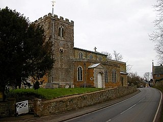
Hellidon is a village and civil parish about 5 miles (8 km) south-west of Daventry in Northamptonshire, England. The parish area is about 1,600 acres (650 ha). It lies 520 feet (160 m) – 590 feet (180 m) above sea level on the north face of an ironstone ridge, its highest point, 670 feet (200 m) at Windmill Hill, being 0.5 miles (800 m) south-east of the village. The Leam and tributaries rise in the parish. The 2011 Census gave a population of 256, estimated at 286 in 2019. The long-distance Jurassic Way footpath linking Banbury, Oxfordshire, and Stamford, Lincolnshire, passes through. The origin of the name is unclear. "Holy Valley", "Haegla's Valley" and "Unstable valley" have been suggested, with the Old English "dun", meaning hill.

<span class="mw-page-title-main">Charwelton</span> Human settlement in England

Charwelton is a village and civil parish about 5 miles (8 km) south of Daventry in Northamptonshire, England. The 2011 Census recorded the parish's population as 220.

<span class="mw-page-title-main">Waltham on the Wolds</span> Village in Leicestershire, England

Waltham on the Wolds is a village and former civil parish, now in the parish of Waltham on the Wolds and Thorpe Arnold, in the Melton borough of Leicestershire, England. It lies about 5 miles (8.0 km) north-east of Melton Mowbray and 11 miles (17.7 km) south-west of Grantham on the main A607 road. In 1931 the parish had a population of 510. The population of Waltham on the Wolds and Thorpe Arnold was 967 in 2011.

<span class="mw-page-title-main">Eaton, Leicestershire</span> Village in Leicestershire, England

Eaton is a village and civil parish in Leicestershire, England, situated in the Vale of Belvoir. The population at the 2011 census was 648. The civil parish includes nearby Eastwell to the west of the village. Eaton has a church, a village hall and a children's park, but the public house called The Castle and its adjacent shop have closed.

The Park Gate Iron and Steel Company was a British company that smelted iron ore and turned it into rolled steel and semi-finished casting products. Its works was at Parkgate, South Yorkshire on a triangular site bounded on two sides by the main road between Rotherham and Barnsley (A633) and the North Midland Railway main line between Rotherham Masborough and Cudworth. It also operated ironstone quarries in Northamptonshire and Leicestershire.

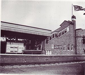
The Hook Norton ironstone quarries (Brymbo) were ironstone quarries near Hook Norton in Oxfordshire, England. The quarries were in operation from 1899 to 1946 supplying ironstone to the Brymbo Steelworks in Wrexham and were served by the Brymbo Ironworks Railway, an extensive, 2 ft (610 mm) narrow gauge industrial railway.

<span class="mw-page-title-main">Great Ponton railway station</span> Former railway station in Lincolnshire, England

Great Ponton railway station was a station on the East Coast Main Line at Great Ponton, Lincolnshire, England. The Great Northern Railway opened it in 1853 and British Railways closed it in 1958. The station buildings were demolished soon after the closure.

<span class="mw-page-title-main">Cranford St John</span> Human settlement in England

Cranford St John is a village and former civil parish, now in the parish of Cranford, in the North Northamptonshire district, in the ceremonial county of Northamptonshire, England. It is in the southern half of the parish of Cranford, next to Cranford St Andrew - both named after the two parish churches. The two settlements are divided by the Alledge Brook, a tributary of the River Nene; the derivation of the name is "ford frequented by cranes or herons". In 1931 the parish had a population of 239. On 1 April 1935 the parish was abolished to form "Cranford".

The Oxfordshire Ironstone Railway was a standard-gauge mineral railway that served an ironstone quarry near the village of Wroxton in Oxfordshire.

<span class="mw-page-title-main">Hook Norton railway station</span> Former railway station in Oxfordshire, England

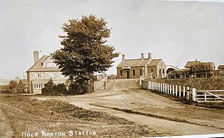
Hook Norton railway station served the village of Hook Norton in northern Oxfordshire, England.

<span class="mw-page-title-main">Eastwell, Leicestershire</span> Human settlement in England

Eastwell is a village and ecclesiastical parish in Leicestershire, England.

The Hook Norton Ironstone Partnership was the first company to quarry ironstone at Hook Norton on a large scale. Although only in operation for twelve years, its quarries subsequently became part of the Brymbo Steelworks quarries and relics of the Partnership's railways and tramways can still be seen today.

<span class="mw-page-title-main">Waltham Iron Ore Tramway</span> Industrial tramway in Leicestershire

The Waltham Iron Ore Tramway was a 1,000 mm gauge industrial tramway serving the ironstone pits of the Waltham Iron Ore Company, a subsidiary of the Staveley Coal and Iron Company. It was located to the north of the village of Branston in Leicestershire on the edge of the Belvoir Estate. The tramway operated from 1884 until 1958.

<span class="mw-page-title-main">Finedonhill Tramway</span> Former industrial narrow-gauge railway in England

The Finedonhill Tramway was a British industrial narrow-gauge railway which operated under various ownership between 1875 and 1926.

<span class="mw-page-title-main">Wellingborough Tramway</span> Narrow-gauge railway in the United Kingdom

The Wellingborough Tramway was an industrial narrow-gauge railway that connected a series of ironstone mines and quarries with the Midland Railway and later with the ironworks on the north side of Wellingborough. In various forms, the tramway operated between 1875 and 1966.

Neilson's Tramway was a British industrial narrow-gauge railway which operated from 1881 to 1929.

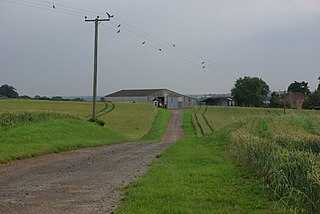
The Eaton Branch Railway was a standard gauge industrial railway built to serve ironstone quarries around the village of Eaton in Leicestershire. It operated from 1884 until 1965.

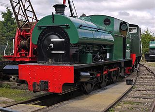
Eric Tonks was an English writer and historian of British industrial railways. He is regarded as one of the pioneers of the industrial archaeology of railways and quarrying. He was also a noted Jazz discographer.

References

52°12′04″N1°12′59″W / 52.2012°N 1.2164°W / 52.2012; -1.2164