Routes

| Preceding station | Disused railways | Following station | ||
|---|---|---|---|---|
| Helmdon Village | SMJR Northampton and Banbury Junction Railway | Towcester |
Wappenham | |
|---|---|
| General information | |
| Location | Wappenham and Slapton, West Northamptonshire England |
| Grid reference | SP635463 |
| Platforms | 1 |
| Other information | |
| Status | Disused |
| History | |
| Original company | Northampton and Banbury Junction Railway |
| Pre-grouping | Stratford-upon-Avon and Midland Junction Railway |
| Post-grouping | London, Midland and Scottish Railway London Midland Region of British Railways |
| Key dates | |
| 1 June 1872 [1] | Opened |
| 2 July 1951 | Closed to passengers |
| 29 October 1951 [2] | Goods facilities withdrawn |
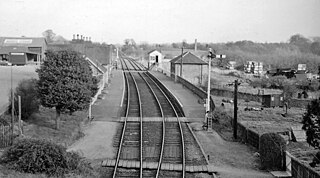
Wappenham was a railway station on the Stratford-upon-Avon and Midland Junction Railway (SMJ) which served the Northamptonshire village of Wappenham between 1872 and 1951. Serving a relatively rural area, the station saw considerable goods traffic generated by local farming communities, but passenger traffic was low which ultimately led to its closure.
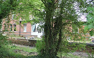
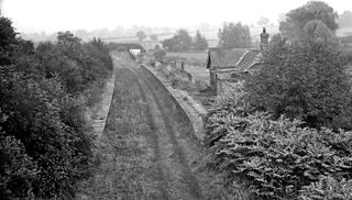
In August 1871, the Northampton and Banbury Junction Railway extended its line from Towcester to Helmdon. [3] A small wayside station was constructed in an isolated spot about a mile from the village of Wappenham from which it took its name. A single-platform was provided on the down side, with a single siding goods yard to the east. The siding was linked to the main line at each end, forming a loop which enabled the yard to be shunted by up or down trains. A symmetrical red brick station building crowned by two large chimneys, similar in style to those at Fairford and Alvescot on the East Gloucestershire Railway, was situated next to the platform and had a central door which led to the waiting room and a separate ladies' waiting room, as well as the ticket and parcels offices; staff accommodation was at the east end of the structure whilst the gentleman's toilets were at the opposite end. [4]
The station served as a useful railhead not only for Wappenham, but also the nearby villages of Slapton and Abthorpe, whose farming communities made use of it for hay and cattle traffic. [5] The station's siding was also of use to RAF Silverstone during the Second World War. [6] Passenger traffic was however sparse, Wappenham was only a small village of 383 people in 1901, [7] and it was one of the least successful in terms of passenger traffic on the line. [8] By the early 1950s, the limited services between Blisworth and Banbury were attracting very few passengers and this resulted in the line's closure to passengers from Monday 2 July 1951, the final trains running on the previous Saturday. Goods traffic continued for three more months. [9]

| Preceding station | Disused railways | Following station | ||
|---|---|---|---|---|
| Helmdon Village | SMJR Northampton and Banbury Junction Railway | Towcester |
The station buildings were demolished after closure and a sewage treatment works has been built on the former railway alignment. [10]
The Stratford-upon-Avon and Midland Junction Railway (SMJR) was a railway company in the southern Midlands of England, formed at the beginning of 1909 by the merger of three earlier companies:

Toddington railway station serves the village of Toddington in Gloucestershire, England. Since 1984 it has been the main base of operations for the heritage Gloucestershire Warwickshire Railway.

Nassington railway station is a former railway station in Nassington, Northamptonshire. It was owned by the London and North Western Railway but from 1883 to 1916 was also served by trains of the Great Northern Railway. It opened for passengers along with Wakerley and Barrowden railway station and King's Cliffe railway station on 1 November 1879, on a new section of line constructed from Wansford Line Junction at Seaton to Yarwell Junction at Wansford.

Farthinghoe was a railway station which served the Northamptonshire village of Farthinghoe in England. It opened in 1851 as part of the Buckinghamshire Railway's branch line to Verney Junction which provided connections to Bletchley and Oxford and closed in 1963.

Brackley Town was a railway station which served the Northamptonshire town of Brackley in England. It opened in 1850 as part of the Buckinghamshire Railway's branch line to Verney Junction which provided connections to Banbury, Bletchley and Oxford and closed in 1963.

Piddington was a railway station on the former Bedford to Northampton Line. Despite its name, the station was located close to the village of Horton in Northamptonshire, approximately 2 miles (3.2 km) from the village of Piddington.
The Bedford–Northampton line was a branch of the Midland Railway which served stations in three counties: Northampton and Horton in Northamptonshire, Olney in Buckinghamshire and Turvey and Bedford in Bedfordshire, England. Opened in 1872, the intermediate stations closed to passengers in 1962, leaving a small section between Northampton and Piddington station to remain open until 1981 for the purposes of the Ministry of Defence establishment. The track remains down on another small section of the line between Northampton and Brackmills. The reopening of the line has been proposed by the Bedfordshire Railway & Transport Association.

Olney was a railway station on the former Bedford to Northampton Line and Stratford-upon-Avon and Midland Junction Railway which served the town of Olney in Buckinghamshire, England. It was situated on a busy section of line between Towcester and Ravenstone Wood junction which saw heavy use by freight services running between Wales and north-east England. The station closed for passengers in 1962 and completely in 1964, the various connecting routes to the line having closed one by one from the 1950s onwards.
Roade was a railway station serving the Northamptonshire village of the same name on the West Coast Main Line. Roade Station opened in 1838 as the principal station for Northampton, but its importance diminished upon the opening of the Northampton and Peterborough Railway in 1845. The construction of the Northampton Loop Line in 1875 made Roade a junction station, and it survived until 1964.
Salcey Forest railway station was a short-lived railway station in England, on the Stratford-upon-Avon, Towcester and Midland Junction Railway which opened on 1 December 1892 near the Northamptonshire forest of the same name. The station was not situated near any settlement and only saw passenger services for four months, it being most likely an error of judgement by the railway company which had provided substantial station facilities in expectation of traffic which never came. Salcey Forest station eventually closed on 31 March 1893 and has an arguable claim, along with Stoke Bruerne, of having had the shortest passenger service ever provided at any British railway station. Goods facilities were withdrawn in 1952.

Northampton St. John's Street was a railway station and the northern terminus of the Midland Railway's former Bedford to Northampton Line which served the English county town of Northampton from 1872 to 1939. Its closure came about as a cost-cutting measure implemented by the London, Midland and Scottish Railway which diverted services to the nearby Northampton Castle station. After closure the elegant station building was used as offices and the line for the storage of rolling stock; the site was cleared in 1960 to make way for a car park. The car park has now been built on and is the location of St Johns Halls of Residence for The University of Northampton.

Stoke Bruern railway station was on the Stratford-upon-Avon, Towcester and Midland Junction Railway which opened on 1 December 1892 near the Northamptonshire village of Stoke Bruerne after which it was misnamed. Passenger services were withdrawn on 31 March 1893. It is arguable that Stoke Bruern along with Salcey Forest have a claim to have had the shortest passenger service of any British railway station. On the first service, it was reported that one person alighted at Salcey Forest, but no-one joined, whilst at Stoke Bruern, seven joined and one alighted. The service attracted no more than twenty passengers a week and the SMJ incurred a loss of £40. The station was situated in a sparsely populated area and only saw passenger services for four months, despite the railway company's optimism which saw substantial station facilities provided in the expectation of traffic which never came. The station remained open for goods until 1952.
Tiffield was a short-lived experimental railway station situated at the highest point of the Stratford-upon-Avon and Midland Junction Railway which opened in 1869 to serve the Northamptonshire village of Tiffield, only to close two years later.

Towcester was a railway station on the Stratford-upon-Avon and Midland Junction Railway which served the Northamptonshire, England, town of Towcester between 1866 and 1964. It was one of the most important stations on the line, and once served as an interchange for services to Stratford, Banbury and Olney. It also saw substantial traffic on racedays at Towcester Racecourse. Its closure came as the various interconnecting lines to the station closed one by one in the 1950s and 1960s. Passenger services ended in 1952, predating the Beeching closures.

Helmdon Village railway station on the Stratford-upon-Avon and Midland Junction Railway (SMJ) served the Northamptonshire village of Helmdon between 1872 and 1951. It was one of two stations serving the lightly populated rural area, the other being Helmdon railway station on the Great Central Main Line, and its closure marked the beginning of the years of decline for the SMJ line.

Blakesley was a railway station on the Stratford-upon-Avon and Midland Junction Railway (SMJ) which served the Northamptonshire village of Blakesley between 1873 and 1962. It was linked to nearby Blakesley Hall by a miniature railway which ran from a terminal adjacent to the station.

Morton Pinkney was a railway station on the Stratford-upon-Avon and Midland Junction Railway (SMJ) which served the Northamptonshire village of Moreton Pinkney between 1873 and 1952. It was situated not far from Sulgrave Manor, the ancestral home of George Washington's family.

Broom Junction was a railway station and interchange between the Stratford-upon-Avon and Midland Junction Railway and the Barnt Green to Ashchurch line. Although initially only an exchange station, it was opened to the public from 1880 and remained in service until 1963. Other than passengers changing trains, passenger traffic was low as the station was situated in a sparsely populated area near Broom in Warwickshire. The line to Stratford was the first to close in 1960, followed by the Barnt Green line in 1962.
The Banbury to Verney Junction branch line was a railway branch line constructed by the Buckinghamshire Railway which connected the Oxfordshire market town of Banbury with the former Oxford/Cambridge Varsity line and the former Metropolitan Railway at Verney Junction, a distance of 21 miles 39 chains. Onward routes from there ran to the West Coast Main Line at Bletchley via Brackley and Buckingham and thence to Cambridge, or to Aylesbury for London.

Weston-sub-Edge railway station is a disused station on the Honeybourne Line from Stratford-upon-Avon to Cheltenham which served the village of Weston-sub-Edge in Gloucestershire between 1904 and 1960.