
Peterborough railway station serves the city of Peterborough, Cambridgeshire, England. It is 76 miles 29 chains (122.9 km) down the East Coast Main Line from London King's Cross. The station is a major interchange serving both the north–south ECML, as well as long-distance and local east–west services. The station is managed by London North Eastern Railway. Ticket gates came into use at the station in 2012.

The Ely–Peterborough line is a railway line in England, linking East Anglia to the Midlands. It is a part of the Network Rail Strategic Route 5, SRS 05.07 and is classified as a secondary line. It is used by a variety of inter-regional and local passenger services from East Anglia to the West Midlands and North West, as well as freight and infrastructure traffic; it also links with the busy East Coast Main Line at its western end. Fenland District council put forward their Rail Development Strategy for the route in 2012, which includes infrastructure upgrades for the intermediate stations, improved frequencies for the services using it and establishing a Community Rail Partnership for the line in 2013/14.
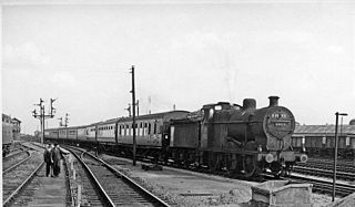
Peterborough East was a railway station in Peterborough, England. It was opened on 2 June 1845 and closed to passenger traffic on 6 June 1966. Located on Station Road just off Town Bridge, only the engine sheds and one platform remain. The station had services running west to Northampton and Rugby, as well as to the east to March, Wisbech, and Norwich.

Luffenham railway station is a former station of the Syston and Peterborough Railway serving the villages of North and South Luffenham, Rutland.
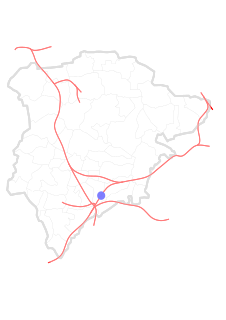
Morcott railway station is a former station in Rutland, near the village of Morcott.

Seaton railway station was a station serving the villages of Seaton, Rutland, and Harringworth, Northamptonshire.

Elton railway station is a former railway station in Elton, Cambridgeshire on former Northampton and Peterborough Railway which connected Peterborough with Northampton via Wellingborough.

Oundle railway station is a Grade II listed former railway station in Oundle, Northamptonshire on the former Northampton and Peterborough Railway line which connected Peterborough and Northampton. In 1846 the line, along with the London and Birmingham, became part of the London and North Western Railway. At grouping in 1923 it became part of the London Midland and Scottish Railway.

Barnwell railway station is a former railway station in Barnwell, Northamptonshire on the former Northampton and Peterborough Railway line which connected Peterborough and Northampton.
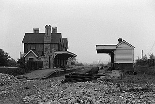
See also Thrapston Midland Road
Ringstead and Addington railway station was a railway station serving Great and Little Addington and Ringstead in Northamptonshire on the former Northampton and Peterborough Railway which connected Peterborough and Northampton.
Irthlingborough railway station is a former railway station in Irthlingborough, Northamptonshire, on the former Northampton and Peterborough Railway line which connected Peterborough and Northampton. In 1846 the line, along with the London and Birmingham Railway, became part of the London and North Western Railway.
Ditchford railway station is a former railway station on Ditchford Road, Northamptonshire on the former Northampton and Peterborough Railway line which connected Peterborough and Northampton.In 1846 the line, along with the London and Birmingham, became part of the London and North Western Railway.
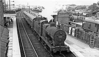
Wellingborough London Road railway station is a former railway station in Wellingborough, Northamptonshire on a line which connected Peterborough and Northampton.

Castle Ashby & Earls Barton railway station is a former railway station in Northamptonshire on the former Northampton and Peterborough Railway, a line which connected Peterborough and Northampton.
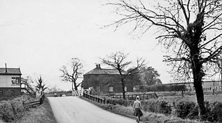
Billing railway station is a former railway station in Northamptonshire on the former Northampton and Peterborough Railway which connected Peterborough and Northampton. In 1846 the line, along with the London and Birmingham, became part of the London and North Western Railway.

Northampton Bridge Street is a former railway station in Northampton, the main town of Northamptonshire, on the Northampton and Peterborough Railway which connected Peterborough and Northampton.
The Northampton and Peterborough Railway was an early railway promoted by the London and Birmingham Railway (L&BR) to run from a junction at Blisworth on the L&BR main line to Northampton and Peterborough, in England. The construction of the line was authorised by Parliament in 1843 and the 47 mile line opened in 1845. The line largely followed the river Nene, and for economy of construction, it had many level crossings with intersecting roads, rather than bridges. In 1846 the L&BR joined with other companies, together forming the London and North Western Railway (LNWR).

Blisworth railway station was a junction station on the London and North Western Railway, the Northampton and Banbury Junction Railway, and the Northampton and Peterborough Railway. As well as providing interchange between the lines, the station served the village of Blisworth in Northamptonshire and its environs. The station was opened by the London and Birmingham Railway (L&BR) in 1838.
Roade was a railway station serving the Northamptonshire village of the same name on the West Coast Main Line. Roade Station opened in 1838 as the principal station for Northampton, but its importance diminished upon the opening of the Northampton and Peterborough Railway in 1845. The construction of the Northampton Loop Line in 1875 made Roade a junction station, and it survived until 1964.


