Fort Stevens was an American military installation that guarded the mouth of the Columbia River in the state of Oregon. Built near the end of the American Civil War, it was named for a slain Civil War general and former Washington Territory governor, Isaac I. Stevens. The fort was an active military reservation from 1863–1947. It is now listed on the National Register of Historic Places.

Civic Stadium was an outdoor athletic stadium in the western United States, located in Eugene, Oregon. For most of its history it was owned by the Eugene School District. Opened in 1938, the stadium was destroyed by fire in 2015 on June 29.

The Oregon State Fair is the official state fair of the U.S. state of Oregon. It takes place every August–September at the 185-acre (0.75 km2) Oregon State Fairgrounds located in north Salem, the state capital, as it has almost every year since 1862. In 2006, responsibility for running the fair was delegated to the Oregon State Parks and Recreation Department, and the division is now known as the Oregon State Fair & Exposition Center (OSFEC), which holds events on the fairgrounds year-round.

Ellendale is a ghost town in Polk County, Oregon, United States, about two and a half miles west of Dallas. It was the first settlement in present-day Polk County by non-Kalapuyans. The community's name changed over the years, with the first post office in Polk County being opened in this locality as "O'Neils Mills" in 1850. The post office was renamed "Nesmiths" in 1850 and discontinued in 1852. The community was eventually renamed Ellendale.
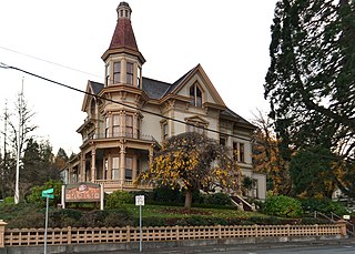
The Captain George Flavel House Museum known also as Capt. George Flavel House and Carriage House or the Flavel Mansion, is now a house museum in Astoria, Oregon, United States. It was built in 1885 in the Queen Anne architectural style, by George Flavel, a Columbia River bar pilot who was one of the area's first millionaires.

Lewisburg is an unincorporated community in Benton County, Oregon, United States. Lewisburg lies at the intersection of Oregon Route 99W and Lewisburg Avenue. Lewisburg is north of Corvallis and west of Albany.

The Portland and Southwestern Railroad Tunnel, also known as the Nehalem Divide Railroad Tunnel, is an abandoned railroad tunnel near Scappoose, Oregon, United States, that is listed on the National Register of Historic Places. The tunnel was driven by the Portland and Southwestern Railroad, whose chief business was logging. Unusually for a logging railroad, the Portland and Southwestern built tunnels. In order to reach the far side of the Nehalem divide in the Northern Oregon Coast Range, the railroad undertook a 1,712-foot (522 m) tunnel. Some work was started in 1910, but most work began in 1918 and was completed in 1919. Since the tunnel was not through solid rock, the tunnel was lined with timber. The tunnel was used until 1945, when it was replaced by a truck road over the divide.

Brunks Corner is an unincorporated community in Polk County, Oregon, United States, at the junction of Oregon Route 22 and Oak Grove Road, near the terminus of Oregon Route 51.

The Earnest Bridge, located near Marcola, Oregon, is listed on the National Register of Historic Places. The name is spelled Ernest Bridge in some documents, including the NRHP listing, but spelled Earnest Bridge in the NRHP nomination and in signage on the bridge itself.

The Lake Creek Bridge also known as the Nelson Mountain Bridge, near Greenleaf, in the U.S. state of Oregon, is listed on the National Register of Historic Places. The 105-foot (32 m) covered bridge, built in 1928, carries Nelson Mountain Road over Lake Creek in Lane County.
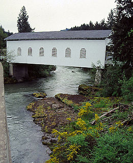
The Dorena Bridge is a covered bridge near Dorena in Lane County, Oregon in the United States. It is listed on the National Register of Historic Places. The 105-foot (32 m) structure crosses the Row River near the upper end of Dorena Reservoir.

The James D. Robb House, located in Forest Grove, Oregon, is a house listed on the National Register of Historic Places.

The Amazon Family Housing Complex was a residential complex located in Eugene, Oregon, formerly listed on the National Register of Historic Places. They were demolished in 1995, and removed from the Register in October 1996.
The Dayton Opera House was an historic opera house located at 318 Ferry Street in Dayton, Oregon, United States. It was added to the National Register of Historic Places on March 16, 1987, but delisted on July 21, 1998.

The Triangle Lake Round Barn, located west of Eugene, Oregon, was built between 1946 and 1949, and added to the National Register of Historic Places on July 3 2017.