
Traffic congestion is a condition in transport that is characterized by slower speeds, longer trip times, and increased vehicular queueing. Traffic congestion on urban road networks has increased substantially since the 1950s. When traffic demand is great enough that the interaction between vehicles slows the traffic stream, this results in congestion. While congestion is a possibility for any mode of transportation, this article will focus on automobile congestion on public roads.

The Beijing–Harbin Expressway, designated as G1 and commonly abbreviated as Jingha Expressway (京哈高速) is an expressway linking the cities of Beijing and Harbin, Heilongjiang.

Jingjintang Expressway, also known as the Jingtang Expressway, links Beijing via central Tianjin to the Tanggu District in eastern Tianjin. 143 kilometres in length, it crosses the jurisdictions of Beijing and Tianjin municipalities and Hebei province.

The 6th Ring Road is an expressway ring road in Beijing, China, which runs around the city approximately 15–20 kilometres (9.3–12.4 mi) from the center of the city. The 6th Ring Road is approximately 220 kilometres (140 mi) long.
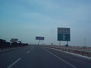
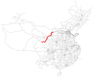
The Jingzhang Expressway is a 79.2 kilometres (49.2 mi) expressway in China connecting Beijing and Zhangjiakou. Construction began in 1998 and finished November 16, 2002. The expressway's name comes from the combination of one-character Chinese abbreviations for Beijing and Zhangjiakou.

The China National Highways (CNH/Guodao) is a network of trunk roads across mainland China. Apart from the expressways of China that are planned and constructed later, most of the CNH are not controlled-access highways.

Beijing, as the capital and one of the four municipalities of the People's Republic of China (PRC), is a transport hub, with a sophisticated network of roads, railways and two major airports. Five completed ring roads encircle the city with nine expressways heading in virtually all compass directions, supplemented by eleven China National Highways.

The expressway network of China, with the national-level expressway system officially known as the National Trunk Highway System, is an integrated system of national and provincial-level expressways in China.

China National Highway 109 connects Beijing with Lhasa. It runs westwards from Beijing via Datong, Yinchuan and Xining to Golmud before turning southwest to Lhasa. The portion of the highway from Xining to Lhasa is known as the Qinghai-Tibet Highway. The total length of the route is 3,901 km.
The Jingbao Expressway is an expressway.

Chifeng, also known as Ulankhad in Mongolian, is a prefecture-level city in Southeastern Inner Mongolia, People's Republic of China. It borders Xilin Gol League to the north and west, Tongliao to the northeast, Chaoyang (Liaoning) to the southeast and Chengde (Hebei) to the south. The city has a total administrative area of 90,275 km2 (34,855 sq mi) and as of the 2020 census, had a population of 4,035,967 inhabitants. However, 1,175,391 of those residents lived in the built-up area made of the 2 urban districts of Hongshan and Songshan, as Yuanbaoshan is not conurbated yet. However, a large part of Songshan district is still rural and Yuanbaoshan district a de facto separate town 27 kilometers away from the core district of Chifeng. The city was the administrative center of the previous Ju Ud League.

Ulanqab or Ulan Chab is a region administered as a prefecture-level city in south-central Inner Mongolia, China. Its administrative centre is in Jining District, which was formerly a county-level city. It was established as a prefecture-level city on 1 December 2003, formed from the former Ulanqab League. The Ulanqab Stadium is located in the city.

Jining District is an urban district that serves as the administrative seat of Ulanqab, a region governed as a prefecture-level city in the mid-western part of Inner Mongolia, China. It has an area of approximately 114.2 km2 and is in the southern foothills of the Yinshan mountains.
Xilinhot is a county-level city which serves as the seat of government for the Xilingol League in Inner Mongolia, China. In 2010, it has a jurisdiction area of 14,785 km2 (5,709 sq mi) and a population of 245,886; 149,000 people live in the Xilinhot urban area.
Transport in Tianjin consists of an extensive network of roads and railways and a major airport. Bicycle is a major means of transport in daily use of the city.
The China National Highway 110 traffic jam was a recurring traffic jam that began to form on 14 August 2010, mostly on China National Highway 110 (G110) and the Beijing–Tibet expressway (G6), in Hebei and Inner Mongolia. The traffic jam slowed thousands of vehicles for more than 100 kilometers (60 mi) and lasted for 12 days. Many drivers were able to move their vehicles only 1 km (0.6 mi) per day, and some drivers reported being stuck in the traffic jam for five days. It is considered to be the longest traffic jam in recorded history.
Linhe–Ceke railway or Lince railway is a railway in the Inner Mongolia Autonomous Region of northwestern China between Linhe District in Bayan Nur, and Ceke, a border post in Ejin Banner on the China–Mongolia border. The railway is 707 km (439 mi) in total length, and runs entirely in desert regions. The line was built with investments of ¥4.27 billion. It opened to freight operations in December 2009 and passenger service in November 2010, but has been plagued by sandstorms and shifting dunes, which have buried tracks and disrupted service.

The Beijing–Lhasa Expressway, commonly abbreviated to Jingzang Expressway, is part of the Chinese national expressway network and is planned to connect the nation's capital, Beijing, to the capital of the Tibet Autonomous Region, Lhasa.

The Rongcheng–Wuhai Expressway, designated as G18 and commonly referred to as the Rongwu Expressway, is an expressway that connects the cities of Rongcheng, Shandong, China, and Wuhai, Inner Mongolia. When fully complete, it will be 1,820 km (1,130 mi) in length.
The Wuhai–Maqên Expressway, designated G1816, is an expressway in China's Inner Mongolia, Ningxia and Gansu provinces.


