Hubei is a landlocked province of the People's Republic of China, and is part of the Central China region. The name of the province means "north of the lake", referring to its position north of Dongting Lake. The provincial capital, Wuhan, serves as a major transportation hub and the political, cultural, and economic hub of central China.

Yichang, alternatively romanized as Ichang, is a prefecture-level city located in western Hubei province, China. It is the third largest city in the province after the capital, Wuhan and the prefecture-level city Xiangyang, by urban population. The Three Gorges Dam is located within its administrative area, in Yiling District.

Badong County is a county located in western Hubei province, People's Republic of China, bordering Chongqing municipality to the west. It is the northernmost county-level division under the administration of Enshi Prefecture. The Yangtze River flows through the county and the county seat is located just east of the Wu Gorge in the Three Gorges region.

Enshi Tujia and Miao Autonomous Prefecture is located in the mountainous southwestern corner of Hubei province, People's Republic of China. It forms Hubei's southwestern "panhandle", bordering on Hunan in the south and Chongqing Municipality in the west and northwest. The Yangtze River crosses the prefecture's northeastern corner in Badong County.

China National Highway 316 (G316) runs from Fuzhou in Fujian to Lanzhou in Gansu, via Nanchang and Wuhan. It is 2915 kilometres in length. The highway crosses the provinces of Gansu, Shaanxi, Hubei, Jiangxi, and Fujian.

China National Highway 207 (G207) runs from Ulanhot, Inner Mongolia to Hai'an, Guangdong. It is 3,738 km (2,323 mi) in length and runs south from Xilinhot through Inner Mongolia, Hebei, Shanxi, Henan, Hubei, Guangxi, and ends in Guangdong.

Rongshui Miao Autonomous County is under the administration of Liuzhou, Guangxi Zhuang Autonomous Region, China. The seat of Rongshui County is Rongshui Town. It borders the prefecture-level divisions of Qiandongnan (Guizhou) to the north and Hechi to the west.

Shennongjia Forestry District is a county-level administrative unit in northwestern Hubei province, People's Republic of China, directly subordinated to the provincial government. It occupies 3,253 square kilometres (1,256 sq mi) in western Hubei, and, as of 2007 had the resident population estimated at 74,000. On July 17, 2016, Hubei Shennongjia was listed as a World Heritage Site, the 50th World Heritage Site in China, because of its exceptional floral and faunal biodiversity and its protection of many rare, endangered, and endemic species.

Muyu is a town in Shennongjia Forestry District, in the west of Hubei province, People's Republic of China. Located on China National Highway 209, it is the main population and services center of the southern part of the district.

Xingshan County is a county of western Hubei, People's Republic of China. It is under the administration of Yichang Prefecture-level City.

Wuhan–Yichang railway, or Hanyi railway, is a 291-kilometre (181 mi) long higher-speed railway between Hankou and Yichang, in Hubei province, China. The railway forms a section of the Huhanrong passenger-dedicated line from Shanghai to Wuhan to Chengdu. The Hanyi Railway was completed in spring 2012 and started commercial operations on July 1, 2012. Adjacent high-speed rail sections, the Hefei–Wuhan railway to the east and the Yichang−Wanzhou railway to the west, opened respectively in April 2009 and December 2010.

The Yichang–Wanzhou railway, or the Yiwan railway connects the cities of Yichang and Wanzhou via Lichuan, Hubei. It was completed in 2010 and forms part of the Shanghai–Wuhan–Chengdu passenger railway. Out of the line's total 377 km (234 mi) length, 288 km (179 mi) runs on bridges or in tunnels. According to the chief engineer, Zhang Mei, the line was the most difficult ever constructed in China. Operation started on 22 December 2010.

The Daba Mountains, also known by their Chinese name as the Dabashan, are a mountain range in Central China between the watersheds of the Yellow and Yangtze Rivers. Part of the larger Qinling mountain range, it cuts through four provinces: Sichuan, Chongqing, Shaanxi, and Hubei. It is about 1,000 kilometers (620 mi) long.

Shanghai–Wuhan–Chengdu passenger-dedicated railway, is a fully completed higher-speed railway corridor in China. It is operated by CR Shanghai Group, CR Wuhan Group and CR Chengdu Group. The Chinese name of the railway line, Huhanrong, is a combination of the abbreviations for Shanghai, Wuhan, and Chengdu, three major cities along the line.

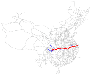
The Shanghai–Chengdu Expressway, designated as G42 and commonly referred to as the Hurong Expressway is an east–west bound expressway that connects the eastern metropolis of Shanghai to Chengdu, the capital city of Sichuan. The expressway passes through six provinces and serves major cities such as Suzhou, Wuxi, Changzhou, Nanjing, Hefei, Wuhan, and Yichang. The eastern terminus of G42 is at the Wuning Road Interchange of Shanghai Middle Ring Road. At its western terminus, the expressway intersects the East 3rd Ring Road and connects East Erxianqiao Road in Chenghua District, Chengdu. The expressway spans 1,960 km (1,220 mi) in length.

The Shanghai–Chongqing Expressway, designated as G50 and commonly referred to as the Huyu Expressway is an east-west bound expressway that connects the cities of Shanghai, China in Yangtze River Delta, and Chongqing in western China. The expressway runs through six provinces/municipalities and adjoin major cities such as Wuhu, Anqing, Wuhan and Yichang, roughly parallel to G42 Shanghai-Chengdu Expressway to its south. The thoroughfare begins at Huqingping Outer Ring Interchange near Hongqiao International Airport, where it meets S20 Outer Ring Expressway in Shanghai, and terminates at an interchange in Jiangbei District, where the highway joins G75 Lanzhou-Haikou Expressway. It is fully complete and spans 1,900 km (1,200 mi) in length.

Shennongjia Hongping Airport is an airport serving the Shennongjia forestry district in the west of Hubei province. It is located in the town of Hongping. Construction started in April 2011 with a total investment of over 1 billion yuan. The airport was opened on 8 May 2014, with an inaugural China Eastern Airlines flight from Shanghai Pudong International Airport with a stop in Wuhan.
Yesanguan railway station (野三关站) is a railway station located in Yesanguan Town, Badong County, Enshi, Hubei Province, People's Republic of China, on the Yiwan Railway which is operated by China Railway Corporation.
Xinhua is a town directly administered by Shennongjia Forestry District, in northwestern Hubei, China, located 26 kilometres (16 mi) southeast of the district seat and 101 kilometres (63 mi) northwest of Yichang. As of 2011, it has one residential community (社区) and nine villages under its administration.


