
Caerleon is a town and community in Newport, Wales. Situated on the River Usk, it lies 5 miles (8 km) northeast of Newport city centre, and 5.5 miles (9 km) southeast of Cwmbran. Caerleon is of archaeological importance, being the site of a notable Roman legionary fortress, Isca Augusta, and an Iron Age hillfort. Close to the remains of Isca Augusta are the National Roman Legion Museum and the Roman Baths Museum. The town also has strong historical and literary associations: Geoffrey of Monmouth elevated the significance of Caerleon as a major centre of British history in his Historia Regum Britanniae, and Alfred Lord Tennyson wrote Idylls of the King (1859–1885) while staying in Caerleon.

Monmouthshire is a county in the south east of Wales. It borders Powys to the north; the English counties of Herefordshire and Gloucestershire to the north and east; the Severn Estuary to the south, and Torfaen, Newport and Blaenau Gwent to the west. The largest town is Abergavenny, and the administrative centre is Usk.

Llanvaches or Llanfaches is a village and community parish within the boundaries of the city of Newport, Wales. It lies to the east of the urban area, in the historic county of Monmouthshire and the preserved county of Gwent. The population rose to 402 by the 2011 census.

Newport Castle is a ruined castle in Newport, Wales. It was built in the 14th century, probably by Hugh de Audley, 1st Earl of Gloucester or his son-in-law, Ralph, Earl of Stafford, with the purpose of managing the crossing of the River Usk. The castle was used as administrative offices for the collection of rent and dues from local tenants, and was also a residence and a garrison. In 1402 it was sacked by Owain Glyndŵr. It was in disrepair by 1522, and was taken by Oliver Cromwell's forces during the Civil War. Its use declined further in later centuries. It has been a Grade II* Listed building since 1951.
Mathern is a historic community (parish) and village in Monmouthshire, south east Wales, about 3 miles (4.8 km) south west of the town of Chepstow, close to the Severn estuary, the Bristol Channel and the M48 motorway. The village is designated as a Conservation Area. It is now bisected by the motorway, which passes over the road through the village, with the original village located to the south and the more recent development, known as Newton Green, to the north.

Cwmyoy is an extensive rural parish in Monmouthshire, Wales. The standard Welsh name is Cwm Iau or Cwm-iau. In the Gwentian dialect of Welsh that was spoken here until the late 1800s, the name was pronounced as Cwm Iou. The 'English' name is in fact this local dialect form in a more English spelling. The name of the valley probably originates from the Welsh word iau meaning yoke, in reference to the shape of the hill surrounding it.

Tredunnock is a small village in Monmouthshire, south east Wales, in the United Kingdom. Tredunnock is located four miles (6.4 km) northeast of Caerleon and four miles south of Usk.

Llangwm is a small rural village and former community, now in the community of Llantrisant Fawr, in Monmouthshire, south east Wales. It is located 3 miles (4.8 km) east of Usk, on the B4235 Chepstow to Usk road. The main village is at Llangwm Uchaf, with a smaller and more dispersed settlement about 1 mile (1.6 km) to the north-east at Llangwm Isaf .The other settlement in the community is Llansoy. In 2022 the community was abolished and merged with Llantrisant Fawr.

Llantrisant is a village in Monmouthshire, south east Wales, United Kingdom. The community population at the 2011 census was 475.
St Pierre is a former parish and hamlet in Monmouthshire, south east Wales, 3 miles (4.8 km) south west of Chepstow and adjacent to the Severn Estuary. It is now the site of a large golf and country club, the Marriott St Pierre Hotel & Country Club, which was previously a large manor house and deer park belonging to the Lewis family.

St David's Church, Llangeview, is a redundant church sited in a round churchyard adjacent to the junction of the A449 and A472 roads 1 mile (1.6 km) to the east of the town of Usk in Monmouthshire, Wales. It has been designated by Cadw as a Grade I listed building, and is under the care of the Friends of Friendless Churches. It is Grade I listed because of its "exceptional interior" including a 15th-century rood-loft and "rare pre-Victorian box pews and fittings". The church stands in a churchyard that is almost circular, and is surrounded by a bank and the traces of a ditch.
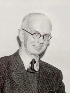
Frederick James Hando MBE was a Welsh writer, artist and schoolteacher from Newport. He chronicled the history, character and folklore of Monmouthshire, which he also called Gwent, in a series of nearly 800 newspaper articles and several books published between the 1920s and 1960s.

Monmouthshire is a county and principal area of Wales. It borders Torfaen and Newport to the west; Herefordshire and Gloucestershire to the east; and Powys to the north. The largest town is Abergavenny, with the other major towns being Chepstow, Monmouth, and Usk. The county is 850 km2 in extent, with a population of 95,200 as of 2020. The present county was formed under the Local Government (Wales) Act 1994, which came into effect in 1996, and comprises some sixty percent of the historic county. Between 1974 and 1996, the county was known by the ancient title of Gwent, recalling the medieval Welsh kingdom. In his essay on local government in the fifth and final volume of the Gwent County History, Robert McCloy suggests that the governance of "no county in the United Kingdom in the twentieth century was so transformed as that of Monmouthshire".
Saint Tathyw was a 5th-century saint of South Wales, and founder of a monastic school at Caerwent where he instructed many of the leading figures of the early Welsh church.

St Cenedlon's is a parish church in the village of Rockfield, Monmouthshire, Wales. The dedication to St Cenedlon is unusual and the history of the saint is obscure. Some sources suggest that she was a daughter of Brychan king of Brycheiniog while others identify her as the wife of King Arthfael ab Ithel, king of Glywysing. The existing church dates from the Middle Ages but only the tower remains from that period. After the English Reformation, the surrounding area of north Monmouthshire became a refuge for Catholics and Matthew Pritchard (1669-1750), Roman Catholic bishop and Vicar Apostolic of the Western District is buried at the church. By the mid-19th century the church was in ruins and a complete reconstruction was undertaken by the ecclesiastical architects John Pollard Seddon and John Prichard in around 1860. St Cenedlon's is an active parish church in the Diocese of Monmouth. It is designated by Cadw as a Grade II listed building.
St Tewdric's Church is a Church in Wales parish church in Mathern, Monmouthshire, Wales. It is purportedly built over the resting place of Saint Tewdrig for whom it is named. A church has been located on the site since the 6th century. It was reconstructed by the Normans in the Early English style, and later was renovated by the Victorians. It is a Grade I listed building.
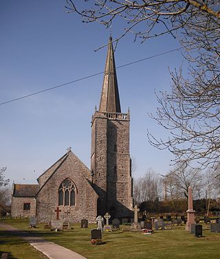
The Church of St Mary the Virgin, Nash is the parish church of the village of Nash, situated about 3 kilometres (1.9 mi) south of the city of Newport, Wales. Described as "the cathedral of the moors" by Monmouthshire historian Fred Hando, the large church is medieval in origin, with additions and restorations dating from the 18th and 19th centuries. Newman describes the 15th-century steeple as "unique in South East Wales". Since 3 January 1963 it has been designated a Grade I listed building primarily due to its "medieval tower with fine spire."

The Church of St Madoc, Llanbadoc, Monmouthshire is a parish church with its origins in the 14th century. A Grade II* listed building, the church remains an active parish church.
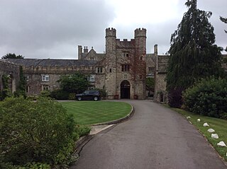
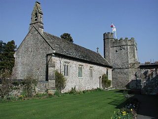
The Gatehouse and attached range, at the St Pierre Hotel, St Pierre, Mathern, Monmouthshire are the most significant remains of the mansion built by the Lewis family in the late 15th century and owned by them until 1924. The original house was built by William Lewis, and extended by his son George, between 1475 and 1508. After the Lewises sold up, the house had a variety of owners and was converted to the clubhouse of a golf club in 1962. It has since been massively extended as a hotel and country club. The gatehouse and range have Grade II* listed building status. The surrounding gardens are included on the Cadw/ICOMOS Register of Parks and Gardens of Special Historic Interest in Wales.
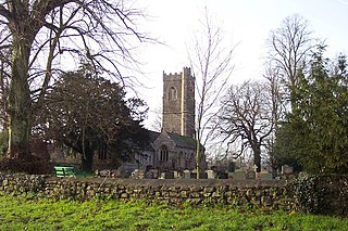
The Church of St Andrew, Tredunnock, Monmouthshire is a parish church with its origins in the 12th or 13th century. A Grade II* listed building, the church remains an active parish church.


