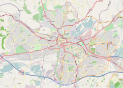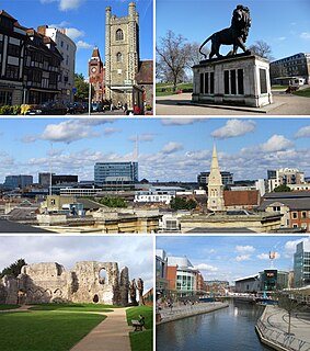
Reading is a town and borough in Berkshire, South-East England. Located in the Thames Valley at the confluence of the rivers Thames and Kennet, the Great Western Main Line railway and the M4 motorway serve the town. Reading is 40 miles (64 km) east of Swindon, 28 miles (45 km) south of Oxford, 40 miles (64 km) west of London, 15 miles (24 km) north of Basingstoke, 13 miles (21 km) southwest of Maidenhead and 15 miles (24 km) east of Newbury.

Caversham is a suburb of Reading, England. Originally a village founded in the Middle Ages, it lies on the north bank of the River Thames, opposite the rest of Reading. Caversham Bridge, Reading Bridge, Christchurch Bridge, and Caversham Lock provide crossing points, with Sonning Bridge also available a few miles east of Caversham. Caversham has at Caversham Court foundations of a medieval house, a herb garden and tree-lined park open to the public at no charge. Caversham Lakes and marking its south and south-east border the Thames Path National Trail. Caversham rises from the River Thames, lying on flood plain and the lowest reaches of the Chiltern Hills.

The River Brent is a river in west and northwest London, England, and a tributary of the River Thames. 17.9 miles (28.8 km) in length, it rises in the Borough of Barnet and flows in a generally south-west direction before joining the Tideway stretch of the Thames at Brentford.

Caversham Lock is a lock and main weir on the River Thames in England at Reading, Berkshire. Both the lock and main weir are connected to De Bohun Island. The Thames Navigation Commissioners built the original lock in 1778. Additional sluices north of View Island and Heron Island form the whole weir complex. A footbridge passes over all three islands to connect Lower Caversham to Reading via a route other than George Street and Reading Bridge.

Pipers Island, or Piper's Island, is the third-smallest map-named island in the River Thames, in England. It is on the Reading, Berkshire reach. It is toward the edge of the central urban area of the town of Reading and connected by a gangway to Caversham Bridge, a road and pedestrian bridge that links that town to its left bank suburb of Caversham.

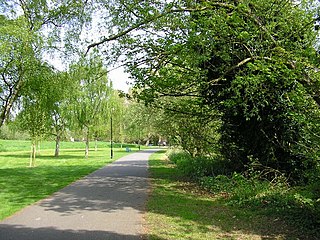
The Thames Path is a National Trail following the River Thames from its source near Kemble in Gloucestershire to the Thames Barrier at Charlton, south east London. It is about 184 miles (296 km) long. A path was first proposed in 1948 but it only opened in 1996.
The Royal Borough of Greenwich has over fifty parks and open spaces within its boundaries. They include:

The London Borough of Newham, in spite of being one of the more crowded areas of London, has over 20 parks within its boundaries, as well as smaller recreation grounds. The larger parks in the Borough include:
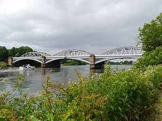
Barnes Railway Bridge is a Grade II listed railway bridge in the London Borough of Richmond upon Thames and the London Borough of Hounslow. It crosses the River Thames in London in a northwest to southeast direction at Barnes. It carries the South Western Railway's Hounslow Loop Line, and lies between Barnes Bridge and Chiswick stations. It can also be crossed on foot, and is one of only three bridges in London to combine pedestrian and rail use; the others being Hungerford Bridge and Golden Jubilee Bridges and Fulham Railway Bridge.

Lower Caversham is an area of the former town of Caversham, in the English county of Berkshire. Today this is itself a suburb of the larger town of Reading. Lower Caversham has no formal boundaries, but the name usually refers to that part of Caversham situated on lower ground to the east of central Caversham, close to the River Thames.

View Island is a small island near Caversham Lock, on the River Thames at Reading, Berkshire in England.

Caversham Court is a public garden and was a mansion located on the north bank of the River Thames in Caversham, a suburb of Reading in the English county of Berkshire. The park lies within the St Peter's conservation area. The park is listed as Grade II in the National Register of Historic Parks and Gardens.
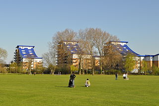
King's Meadow is a park in Reading, Berkshire, England, located next to the River Thames. It stretches from the Coal Woodland to King's Meadow Road near Reading Bridge. The Thames Path long distance footpath runs through the length of King's Meadow, which is visible from the railway when entering or leaving Reading railway station from the eastern side.

Reading's location in the Thames Valley at the confluence of the River Thames and River Kennet, and on both the Great Western Main Line and the M4 motorway, some 40 miles (64 km) west of London has made the town an important location in the nation's transport system.

Christchurch Bridge, originally known as the Reading Pedestrian and Cycle Bridge, is a pedestrian and cycle bridge over the River Thames at Reading in the English county of Berkshire. The bridge links the centre of Reading on the south bank with the cross-river suburb, and former village, of Caversham on the north bank. It crosses the river some 200 metres (660 ft) above Reading Bridge, and immediately downstream of Fry's Island.
Watchmoor is an area in Camberley, Surrey, England, off the A331 Blackwater Valley Road. It is located opposite the Blackwater Valley Path. It is split into two parts: Watchmoor Park business park and Watchmoor Point industrial estate are accessed via Riverside Way, whilst the Sainsbury's Watchmoor Park Superstore and the Watchmoor Reserve nature area are accessed via a completely separate road mainly hidden from public view by trees, shrubs and hedges. The two sections are only connected via a pedestrian footpath.
Dukes Meadows Footbridge is a pedestrian bridge under construction in Chiswick, London that will allow the Thames Path on the north bank at Dukes Meadows to follow the river without diversion.
Thames is an electoral ward of the Borough of Reading, in the English county of Berkshire. It includes areas on both sides of both the River Thames and the River Kennet, to the north and east of the centre of Reading on the south bank, and to the east of the centre of Caversham on the north bank. It should not be confused with the ward of the same name that existed prior to the 2022 Reading Borough Council election, with which it has no area in common.
Hills Meadow is a park in Reading, Berkshire, England, located next to the River Thames. It stretches along the north (Caversham) side of the river, to the east of Reading Bridge. It is linked to the south (Reading) bank by a footpath, locally known as The Clappers that crosses View Island and the weir at Caversham Lock.

Thameside Promenade, or Thames Side Promenade, is a public park and promenade in Reading, Berkshire, England, located next to the River Thames. It stretches along the south (Reading) side of the river, to the west of Caversham Bridge, and forms part of the Thames Path long distance footpath. The park includes grassland behind the promenade.