
Baltistan also known as Baltiyul or Little Tibet, is a mountainous region in the Pakistani-administered territory of Gilgit–Baltistan. It is located near the Karakoram and borders Gilgit to the west, China's Xinjiang to the north, Indian-administered Ladakh to the southeast, and the Indian-administered Kashmir Valley to the southwest. The average altitude of the region is over 3,350 metres (10,990 ft). Baltistan is largely administered under the Baltistan Division.

Kargil district is a district in Indian-administered Ladakh in the disputed Kashmir-region. It is one of the two districts comprising the Indian-administered union territory of Ladakh. The district headquarters are in the city of Kargil. The district is bounded by the Indian-administered union territory of Jammu and Kashmir to the west, the Pakistani-administered administrative territory of Gilgit–Baltistan to the north, Ladakh's Leh district to the east, and the Indian state of Himachal Pradesh to the south. Encompassing three historical regions known as Purig, Dras and Zanskar, the district lies to the northeast of the Great Himalayas and encompasses the majority of the Zanskar Range. Its population inhabits the river valleys of the Dras, Suru, Wakha Rong, and Zanskar.

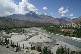
Skardu is a city located in Gilgit-Baltistan, in Pakistan. Skardu serves as the capital of Skardu District and the Baltistan Division. It is situated at an average elevation of nearly 2,500 metres above sea level in the Skardu Valley, at the confluence of the Indus and Shigar rivers. The city is an important gateway to the eight-thousanders of the nearby Karakoram mountain range. The Indus River running through the region separates the Karakoram from the Ladakh Range.

Kargil or Kargyil is a city in Indian-administered Ladakh in the disputed Kashmir region. It is the joint capital of Ladakh, an Indian-administered union territory. It is also the headquarters of the Kargil district. It is the second-largest city in Ladakh after Leh. Kargil is located 204 kilometres (127 mi) east of Srinagar in Jammu and Kashmir, and 234 kilometres (145 mi) to the west of Leh. It is on the bank of the Suru River near its confluence with the Wakha Rong river, the latter providing the most accessible route to Leh.

Ladakh is an administrative territory of India that has been under its control since 1947. The geographical region of Ladakh union territory is the highest altitude plateau region in India, incorporating parts of the Himalayan and Karakoram mountain ranges and the upper Indus River and valley.
The Suru River is a tributary of the Indus River that flows largely through the Kargil district of Ladakh, India. The Suru Valley is coextensive with the Kargil tehsil, with the town of Kargil situated on its banks. The river enters the Kharmang District of Pakistani-administered Gilgit-Baltistan, coursing a brief length before joining the Indus near Marol.

The Shingo River is a tributary of the Indus River, and flows through Gilgit-Baltistan and Kargil regions. The river originates in Gilgit-Batistan and flows into the Kargil district where it joins the Dras River. The combined river receives the waters of the Suru River and flows into Baltistan again, joining the Indus River river near Marol.

The Brokpa, sometimes referred to as Minaro, are a small ethnic group mostly found in the union territory of Ladakh, India around the villages of Dha and Hanu. Some of the community are also located across the Line of Control in Baltistan in the villages around Ganokh. They speak an Indo-Aryan language called Brokskat. The Brokpa are mostly Vajrayana Buddhist while some are Muslim.
Batalik is a village and military base in Ladakh, India, located in a narrow section of the Indus river valley, close to the Line of Control with Pakistan-administered Baltistan. It was a focal point of the 1999 Kargil War because of its strategic location between Kargil, Leh and Baltistan.

Chorbat Valley is a section of the Shyok river valley divided between Pakistan-administered Gilgit-Baltistan and Indian-administered Ladakh. The Pakistan-administered portion is in the Khaplu tehsil of Ghanche District in Gilgit–Baltistan, and the Indian-administered portion is in the Nubra tehsil, Leh district of Ladakh. Chorbat stretches from the edge of Khaplu to the Chalunka village of Nubra.
The Kharmang Valley, also known as Kartaksho, is one of the five main valleys situated in Gilgit–Baltistan region of Pakistan. The area became an individual district in 2015, with its temporary headquarters set at the town of Tolti. The valley is located 120 kilometres (75 mi) from the city of Skardu.

Rondu District, also spelled Roundu District, is a district of Pakistan-administered Gilgit-Baltistan in the disputed Kashmir region. It is one of 14 districts of Gilgit-Balistan. The district encompasses the entire Roundu Valley, which is the fourth-largest valley in Gilgit-Baltistan, after the Skardu, Khaplu, and Shigar valleys. The Roundu valley lies in the western part of the Baltistan Division and forms the main trade and travel route between the Baltistan Division and the Gilgit Division. The Rondu District was carved out of Skardu District in 2019.
Gultari Valley, located west of Kargil town with Skardu 288 km to its north and Dras in south, is amongst the biggest valleys of Pakistan-administered Baltistan on the disputed India Pakistan Line of Control (LoC) in Himalaya. It comprises three sub-valleys, Shingo, Saigar and Phultukus, with the majority people speaking the Shina language. Galtari is a district subdivision in Skardu District of Pakistan-administered Gilgit-Baltistan in the disputed Kashmir region, with 10,000 population spread across 16 revenue estate villages, some of which have several isolated hamlets.
Olding, originally Olthingthang or Olthing Thang, is a village in the Dras River valley in the Kharmang District of Baltistan, Pakistan. The village is 8,676 feet (2,644 m) above the sea level. It is close to the India-Pakistan border (LOC), and lies on the traditional trade route between Baltistan and Ladakh via Kargil.

The Skardu–Kargil Road is a 126-kilometre (78 mi) provincial highway in the Pakistani-administered territory of Gilgit–Baltistan, running from the city of Skardu to the Line of Control with the Indian-administered territory of Ladakh, via the Kharmang Valley. The original road continued to run until the town of Kargil, but has been closed since 1948.
Garkon is a panchayat village in the Aryan valley region located in the Kargil block of Kargil district, in a rural region of the Indian union territory of Ladakh. It is located east of Batalik in Aryan Valley of Indus river system.
Darchik is a village in the Kargil district of Ladakh, primarily populated by the Brokpa people.

Aryan Valley, historically known as Dah Hanu region, is an area comprising four village clusters — Dah and Hanu in Leh district, and Garkon and Darchik in Kargil district — in Central Ladakh in India. It is inhabited by Brokpa people of Dardic origin. Until its absorption into the Maryul kingdom, Brokpa chiefs wielded nominal autonomy in the region.
Ganokh, locally called Ganishah, is a village in the Kharmang District of Baltistan, Pakistan, close to the Line of Control with Indian-administered Ladakh. It is populated by Brokpas professing Shia Islam.
Marol is a village situated near the confluence of the Suru River and the Indus River in the Kharmang District of Baltistan, Pakistan. It is close to the India–Pakistan border (LOC).

