The J Church is a hybrid light rail/streetcar line of the Muni Metro system in San Francisco, California. The line runs between Embarcadero station and Balboa Park station through Noe Valley. Opened on August 11, 1917, it is the oldest and has the lowest ridership of all of the Muni Metro lines.

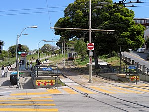
Right Of Way/20th Street station is a light rail stop on the Muni Metro J Church line, located in the southwest corner of Dolores Park in San Francisco, California. The stop opened with the line on August 11, 1917. The station has two side platforms where passengers board or depart from trains. The stop is not accessible to people with disabilities.
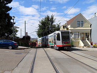
Right Of Way/Liberty station is a light rail stop on the Muni Metro J Church line, located in the Dolores Heights neighborhood of San Francisco, California. The stop, which opened with the line on August 11, 1917, is located on a short rail-only right of way that allows the line to avoid the steep hill on Church Street to the west. Due to the limited width of the right of way, the stop does not have platforms, trains stop in the middle of Liberty Street allowing passengers to step on or off trains. The stop is not accessible to people with disabilities.

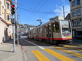
Right Of Way/21st Street station is a light rail stop on the Muni Metro J Church line, located in the Dolores Heights neighborhood of San Francisco, California. The stop, which opened with the line on August 11, 1917, is located on a short rail-only right of way that allows the line to avoid the steep hill on Church Street to the west. The stop has a pair of side platforms located south of 21st Street on a sharp curve. The stop is not accessible to people with disabilities.

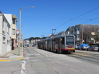
Church and 22nd Street station is a light rail stop on the Muni Metro J Church line, located in the Noe Valley neighborhood of San Francisco, California. The stop, which opened with the line on August 11, 1917, is located on Church Street just south of a short rail-only right of way that allows the line to avoid a steep hill on Church Street near 21st Street. The stop has no platforms, trains stop at marked poles just south of 22nd Street and passengers cross a parking lane on Church Street to board trains. The stop is not accessible to people with disabilities.

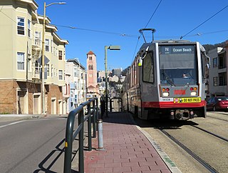
Church and 24th Street is a light rail stop on the Muni Metro J Church line, located in the Noe Valley neighborhood of San Francisco, California. The stop opened with the line on August 11, 1917. The station has two side platforms in the middle of Church Street where passengers board or depart from trains. The station also has mini-high platforms providing access to people with disabilities.

Church and 29th Street / Church and Day stations are a pair of light rail stops on the Muni Metro J Church line, located in the Noe Valley neighborhood of San Francisco, California. The eastbound (inbound) stop is located on Church Street at 29th Street, while westbound trains stop on Church Street at Day Street. The stops opened with the line on August 11, 1917. Until the 1991 extension to Balboa Park station, the line's outer terminus was just to the south at 30th Street. The station has two side platforms in the middle of Church Street where passengers board or depart from trains. The station also has mini-high platforms providing access to people with disabilities.
30th Street and Dolores station is a light rail stop on the Muni Metro J Church line, located in the Bernal Heights neighborhood of San Francisco, California. The stop has no platforms, trains stop at marked poles before the crossing Dolores Street and passengers cross a vehicle travel lanes on 30th Street to board trains. The stop is not accessible to people with disabilities.

Taraval and 22nd Avenue / Taraval and 23rd Avenue stations are a pair of light rail stops on the Muni Metro L Taraval line, located in the Parkside neighborhood of San Francisco, California. The eastbound stop is located on Taraval Street and 22nd Avenue, while westbound trains stop on Taraval Street at 23rd Avenue.

Taraval and Sunset is a light rail stop on the Muni Metro L Taraval line, located in the Parkside neighborhood of San Francisco, California. The station opened with the second section of the L Taraval line on January 14, 1923.
Taraval and 42nd Avenue is a light rail stop on the Muni Metro L Taraval line, located in the Parkside neighborhood of San Francisco, California. The station opened with the first section of the L Taraval line on January 14, 1923.
Taraval and 44th Avenue is a light rail stop on the Muni Metro L Taraval line, located in the Parkside neighborhood of San Francisco, California. The station opened with the second section of the L Taraval line on January 14, 1923.

46th Avenue and Taraval (eastbound) and Taraval and 46th Avenue (westbound) are a pair of one-way light rail stops on the Muni Metro L Taraval line, located in the Parkside neighborhood of San Francisco, California.

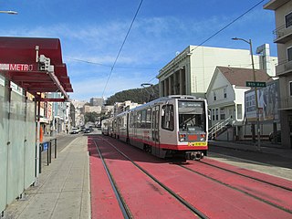
Carl and Stanyan station is a light rail stop on the Muni Metro N Judah line, located in the Cole Valley neighborhood of San Francisco, California. The station opened with the N Judah line on October 21, 1928. It is located two blocks away from Kezar Stadium. The has a transit bulb in the eastbound direction, which extends the sidewalk of Carl Street, to meet trains like a side platform, allowing passengers to board or depart from trains. In the westbound direction, passengers wait on the sidewalk and cross a lane of traffic to board trains. The station is not accessible to people with disabilities.

Irving and 8th Avenue / 9th Avenue and Irving stations are a pair of one-way light rail stops on the Muni Metro N Judah line, located in the Sunset District neighborhood of San Francisco, California. The eastbound stop is located on Irving Street at 8th Avenue, while westbound trains stop on 9th Avenue at Irving Street. The station has transit bulbs which extend the sidewalk of Irving Street and 9th Avenue to meet trains like a side platform, allowing passengers to board or depart from trains. The station is not accessible to people with disabilities.
Judah and 9th Avenue is a light rail stop on the Muni Metro N Judah line, located in the Sunset District neighborhood of San Francisco, California. The station opened with the N Judah line on October 21, 1928. The station has two side platforms in the middle of Judah Street where passengers board or depart from trains. The station also has mini-high platforms providing access to people with disabilities.
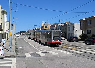
Judah and 15th Avenue / Judah and 16th Avenue stations are a pair of light rail stops on the Muni Metro N Judah line, located in the Sunset District neighborhood of San Francisco, California. The eastbound stop is located on Judah Street at 15th Avenue, while westbound trains stop on Judah Street at 16th Avenue. The stops opened with the N Judah line on October 21, 1928. The station has two short side platforms in the middle of Judah Street where passengers board or depart from trains. The station is not accessible to people with disabilities.

Judah and 28th Avenue is a light rail stop on the Muni Metro N Judah line, located in the Sunset District neighborhood of San Francisco, California. The stop opened with the N Judah line on October 21, 1928. The station has two side platforms in the middle of Judah Street where passengers board or depart from trains. The station also has mini-high platforms providing access to people with disabilities.

15th Avenue and Taraval is a westbound-only light rail stop on the Muni Metro L Taraval line, located in the Parkside neighborhood of San Francisco, California. The station opened with the first section of the L Taraval line on April 12, 1919. Eastbound trains stop at the nearby Taraval and 17th Avenue station.

Irving and 5th Avenue / Irving and 6th Avenue stations are a pair of light rail stops on the Muni Metro N Judah line, located in the Sunset District neighborhood of San Francisco, California. The eastbound stop is located on Irving Street at 5th Avenue, while westbound trains stop on Irving Street at 6th Avenue.