Churchill Meadows

Last updated
Churchill Meadows
Neighbourhood
Peel locator map 2021.svg
Red pog.svg
Churchill Meadows
Location of Churchill Meadows in Mississauga
Canada Southern Ontario relief location map.jpg
Red pog.svg
Churchill Meadows
Location of Churchill Meadows in Southern Ontario
Coordinates: 43°33′N79°44′W / 43.550°N 79.733°W / 43.550; -79.733
Country Flag of Canada (Pantone).svg  Canada
Province Flag of Ontario.svg  Ontario
Regional municipality Peel
City Mississauga
Government
   MP Iqra Khalid
   MPP Sheref Sabawy
   Councillor Sue McFadden (Ward 10), Matt Mahoney (Ward 8)
Population
 (2016)
  Total47,800 [1]
Forward sortation area
L5M

Churchill Meadows is a suburban residential neighbourhood located in the westernmost area of Mississauga, Ontario, Canada. In 2016, Churchill Meadows had a population of 47,800. Postal codes in this area are L5M, and area codes, are 905, and 289. It is located near Erin Mills and the Erin Mills Town Centre. A large community centre and sport park will be built in the community, known as the Churchill Meadows Community Centre.

Contents

History

The area that Churchill Meadows occupies was originally part of The Town of Milton. Following the establishment of the City of Mississauga in 1974, the area of Churchill Meadows was officially incorporated into the City of Mississauga. The official neighbourhood boundaries for Churchill Meadows is Ninth Line to the west, Britannia Road to the North, Winston Churchill Boulevard to the east and the 403 to the south. [2]

Designed in 1981, the primary plan for Churchill Meadows specified the creation of residential units for the lands north of Eglinton Avenue West and mixed industrial and commercial for the lands located south of Eglinton Avenue West. [2] From 1987 to 1997 secondary plans were created for the newly formed Churchill Meadows Planning district. Finally, in 1997 urban design guidelines outlining the design intent of Churchill Meadows were provided to public and private sector developers. The main principles of the guidelines included a variety of housing types, parks, schools, stormwater management facilities, and a grid pattern of streets within the area. The bulk of the construction and development began in 1997 and ended in 2001. Further development continued through to 2010.It is one of the newest communities in Mississauga and development is still continuing. [2]

Housing

As originally planned by the City of Mississauga the neighbourhood of Churchill Meadows has a wide variety of housing options including fully detached, semi-detached, town houses and condos. Original home owners within Churchill Meadows have seen a great increase in the value of their homes as the average price of homes in Churchill Meadows has increased substantially as of 2017. [3] Homes located in Churchill Meadows are known to sell relatively quickly and for a premium. [4] As one of the newest neighbourhoods in Mississauga, young families have been mostly attracted to the relatively new real estate properties located in Churchill Meadows. As of 2015 the average price for a fully detached house is $815,086. The average price for a semi-detached house is $597,327 and the average price for a town house is $543,063. [5]

Neighbourhood character

The architecture of Churchill Meadows, especially in the southern half of the neighbourhood is quite notable. Almost all of the main streets are lined with medium density town homes, low rise condos and work/live developments. Developers paid particular attention to detail on home exteriors, with classic designs utilizing modern materials. The interior of most homes features modern finishes, layouts and designs. [4]

The residents of Churchill Meadows features a diverse, upwardly mobile, cosmopolitan community. Much of Churchill Meadows is made up of double income, professional families. Due to the rising prices of homes in the neighbourhood many homes in the neighbourhood are sought after by middle to upper middle class buyers. [4]

Churchill Meadows has many small and large parks woven throughout the neighbourhood. Churchill Meadows Community Centre is attached to St. Joan of Arc Catholic Secondary School. The community centre features Churchill Meadows Public Library which it shares with St. Joan of Arc Students during the school year. The community centre also features a dance studio and two gymnasiums that are also utilized by St. Joan of Arc Students during the school year. The Churchill Meadows Community Centre is known to host a variety of family oriented events throughout the year and is popular among families with young children. [4]

Demographics

Churchill Meadows top six ethnic and cultural groups (by ancestry) in 2011: [3]

Schools

Churchill Meadows is served by a variety of public, private and catholic schools. Public elementary schools include Artesian Drive PS, Oscar Peterson PS, McKinnon PS, and Churchill Meadows PS. Catholic elementary schools include St.Sebastian, St.Faustina, and St.Bernard Of Clairvaux. The only private school located in Churchill Meadows is Sherwood Heights Elementary School that opened in 2017. The two public middle schools located in Churchill Meadows include Erin Centre Middle school, and Ruth Thompson Middle school. The sole public high school in Churchill Meadows is Stephen Lewis Secondary School while its catholic counterpart located directly across from it is St. Joan of Arc Catholic Secondary School. [6]

See also

Related Research Articles

<span class="mw-page-title-main">Mississauga</span> City in Ontario, Canada

Mississauga, historically known as Toronto Township, is a city in the Canadian province of Ontario. It is situated on the shores of Lake Ontario in the Regional Municipality of Peel, adjoining the western border of Toronto. With a population of 717,961 as of 2021, Mississauga is the seventh-most populous municipality in Canada, third-most in Ontario, and second-most in the Greater Toronto Area (GTA) after Toronto itself. However, for the first time in its history, the city's population declined according to the 2021 census, from a 2016 population of 721,599 to 717,961, a 0.5 percent decrease.

<span class="mw-page-title-main">Etobicoke</span> District of Toronto, Ontario, Canada

Etobicoke is an administrative district and former city within Toronto, Ontario, Canada. Comprising the city's west-end, Etobicoke is bordered on the south by Lake Ontario, on the east by the Humber River, on the west by Etobicoke Creek, the cities of Brampton, and Mississauga, the Toronto Pearson International Airport, and on the north by the city of Vaughan at Steeles Avenue West.
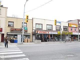
<span class="mw-page-title-main">Newtonbrook</span> Neighbourhood of Toronto

Newtonbrook is a neighbourhood in Toronto, Ontario, Canada. It is located in the area around Yonge Street and Finch Avenue in the district of North York between the east and west branches of the Don River. Officially, the area is divided into two neighbourhoods; Newtonbrook West and Newtonbrook East.

<span class="mw-page-title-main">Malvern, Toronto</span> Neighbourhood in Toronto, Ontario, Canada

Malvern is a neighbourhood in the city of Toronto, Ontario, Canada, with a population of 44,315. It is located in the northeast corner of the city.

<span class="mw-page-title-main">Richview, Toronto</span> Neighbourhood in Toronto, Ontario, Canada

Richview, formally known as Willowridge-Martingrove-Richview, is a neighbourhood in the city of Toronto, Ontario, Canada. It is bounded on the west by Highway 401 and on the north by the highway and by Dixon Road, Royal York Road on the east, and Eglinton Avenue West along the south. Richview was originally established as a postal village within the then-agricultural Etobicoke Township, which later became the suburb of Etobicoke.

<span class="mw-page-title-main">Flemingdon Park</span> Neighbourhood in Toronto, Ontario, Canada

Flemingdon Park is a neighbourhood in Toronto, Ontario, Canada, located in the city's North York district. It is part of the Don Valley East federal and provincial electoral districts, and Ward 26: Don Valley East (South) municipally. In 2011, its population was 22,205. The average income was $66,784.

<span class="mw-page-title-main">Victoria Village</span> Neighbourhood in Toronto, Ontario, Canada

For the settlement established by former slaves in Guyana known as Victoria Village see Victoria, Guyana

<span class="mw-page-title-main">Don Valley Village</span> Neighbourhood in Toronto, Ontario, Canada

Don Valley Village is a neighbourhood in the city of Toronto, Ontario, Canada. It is located in the former suburb of North York. Located north of Highway 401 and bisected by Don Mills Road, it is bounded by Sheppard Avenue to the south, Leslie Street to the west, Finch Avenue to the north and Highway 404 to the east. Like the nearby Don River Valley, the neighbourhood has hill and dale topography.

<span class="mw-page-title-main">Humewood–Cedarvale</span> Neighbourhood in Toronto, Ontario, Canada

Humewood–Cedarvale is an area of Toronto, Ontario, Canada, consisting of Humewood in the south, divided by Vaughan Road and Cedarvale Ravine. The neighbourhood is bordered by Bathurst Street on the east, Eglinton Avenue to the north, Arlington Avenue to the west, and St. Clair Avenue to the south. Humewood has also been known as "the Woods" because of its many streets that have names ending with "-wood", including Wychwood, Humewood, Cherrywood, Valewood, Maplewood, Wellwood, Kenwood, and Pinewood. The neighbourhood's main commercial areas are along St. Clair Ave. W., referred to as Hillcrest Village and along Eglinton Ave. W..

<span class="mw-page-title-main">Fairbank, Toronto</span> Neighbourhood in Toronto, Ontario, Canada

Fairbank is a neighbourhood in Toronto, Ontario, Canada. The area is centred on the intersection of Dufferin Street and Eglinton Avenue West. Fairbank includes the neighbourhoods of Briar Hill–Belgravia and Caledonia–Fairbank. The western border is the CNR lines. The northern and southern borders are the former borders of the City of York and the eastern border is Dufferin Street.

<span class="mw-page-title-main">Silverthorn, Toronto</span> Neighbourhood in Toronto, Ontario, Canada

Silverthorn, often misspelled as Silverthorne, is a neighbourhood and former postal village in Toronto, Ontario, Canada. The approximate boundaries are the GO Transit Barrie line railway tracks to the east, Black Creek Drive and the CP railway line to the west and the former boundaries of the City of York to the north and south. The neighbourhood west of Keele Street is known as Keelesdale. For demographic purposes, the city breaks the area down into two neighbourhoods Keelesdale-Eglinton West, south of Eglinton, and Beechborough-Greenbrook north of Eglinton. It was originally a postal village to serve the then-agricultural York Township.

<span class="mw-page-title-main">Rockcliffe–Smythe</span> Neighbourhood in Toronto, Ontario, Canada

Rockcliffe–Smythe is a neighbourhood in Toronto, Ontario, Canada. It was developed after World War II as part of the urbanization of the former suburb of York Township. It is in Ward 5 in the City of Toronto.

<span class="mw-page-title-main">Clairlea</span> Neighbourhood in Toronto, Ontario, Canada

Clairlea is a neighbourhood in Toronto, Ontario, Canada. The neighbourhood is located in the western part of the district of Scarborough just east of Victoria Park Avenue. To the north, it is bounded by Eglinton Avenue and to the south by Taylor-Massey Creek and the railway tracks. The neighborhood is served by Warden station and the Don Valley Parkway. A large portion of Clairlea-Birchmount is taken up by shopping centres, the Eglinton Square Shopping Centre and other large retail developments along what was once Scarborough’s old Golden Mile of Industry on Eglinton Avenue.

<span class="mw-page-title-main">Woburn, Toronto</span> Neighbourhood in Toronto, Ontario, Canada

Woburn is a neighbourhood located in eastern Toronto, Ontario, Canada, in the former suburb of Scarborough. Woburn is bordered by Highway 401 to the north, Orton Park Road to the east, Lawrence Avenue to the south, and McCowan Road to the west.

<span class="mw-page-title-main">Eglinton East</span> Neighbourhood in Toronto, Ontario, Canada

Eglinton East, historically known as Knob Hill, is a residential and commercial neighbourhood in Toronto, Ontario, Canada. It is bounded by Stansbury Crescent, Citadel Drive, and West Highland Creek to the north, Midland Avenue to the west, the CNR rail line, Brimley Road, and Eglinton Avenue to the south, and Bellamy Road North to the east.

<span class="mw-page-title-main">Nutana Park, Saskatoon</span> Neighbourhood in Saskatoon, Saskatchewan, Canada

Nutana Park is a mostly residential neighbourhood located in south-central Saskatoon, Saskatchewan, Canada. It is a suburban subdivision, consisting mostly of low-density, single detached dwellings. As of 2007, the area is home to 2,748 residents. The neighbourhood is considered a middle-income area, with an average family income of $66,555, an average dwelling value of $257,789 and a home ownership rate of 85.1%. According to MLS data, the average sale price of a home as of 2013 was $356,116.

<span class="mw-page-title-main">Princess Gardens</span> Neighbourhood in Toronto, Ontario, Canada

Princess Gardens is a neighbourhood in Toronto, Ontario, Canada. It is located in the western area of Toronto that was formerly the City of Etobicoke. Its boundaries are Eglinton Avenue to the north, Martin Grove to the west, Islington to the east, and Rathburn Road to the south. The southeastern part of this area is the separate neighbourhood of Thorncrest Village. The neighbourhood is divided into two areas: The portion east of Kipling Road is known as Princess Anne Manor, while the portion west of Kipling is Princess Margaret Gardens. They are named after Princess Anne, Princess Royal, and Princess Margaret, Countess of Snowdon, the daughter and sister of the late Queen Elizabeth II respectively. Both Princesses visited the Gardens and opened up Princess Margaret Public School during its opening ceremony. The southwestern part of the neighbourhood is also sometimes known as Glen Agar. Princess Gardens has some of the highest income Canadians in the Greater Toronto Area according to a 2016 census, at an average of $222,218 per year.

Stephen Lewis Secondary School is a high school located in the Churchill Meadows neighbourhood of the city of Mississauga in Ontario, Canada and is a part of the Peel District School Board. It is one of two schools bearing this name. It opened in September 2006. Its feeder schools are Ruth Thompson Middle School and Erin Centre Middle School.

<span class="mw-page-title-main">St. Joan of Arc Catholic Secondary School</span> Catholic high school in Mississauga, Ontario, Canada

St. Joan of Arc Catholic Secondary School is a school administered by the Dufferin-Peel Catholic District School Board, located in the Churchill Meadows neighbourhood of Mississauga, Ontario, Canada. Churchill Meadows Branch of the Mississauga Library System is attached to the school, which shares its facilities.

References

  1. "Population, Demographics & Housing". City of Mississauga. Retrieved 15 January 2021.
  2. 1 2 3 "Churchill Meadows : Community Preview" (PDF). Mississauga.ca. Retrieved 30 August 2017.
  3. 1 2 "Mississauga's Neighbourhoods: Churchill Meadows". Amitandroy.com. Archived from the original on 5 September 2017. Retrieved 30 August 2017.
  4. 1 2 3 4 "Churchill Meadows - Mississauga - Real Estate - Agent - Jeff O'Leary". Thevillageguru.com. Retrieved 30 August 2017.
  5. "Churchill Meadows Real Estate Statistics May 2015". Mychurchillmeadows.ca. 2 June 2015. Retrieved 30 August 2017.
  6. "Churchill Meadows - Mississauga Neighbourhoods". Gtawestliving.com. 31 July 2015. Retrieved 30 August 2017.