Clay County is located in the U.S. state of Missouri and is part of the Kansas City metropolitan area. As of the 2020 census, the county had a population of 253,335, making it the fifth-most populous county in Missouri. Its county seat is Liberty. The county was organized January 2, 1822, and named in honor of U.S. Representative Henry Clay from Kentucky, later a member of the United States Senate and United States Secretary of State.

Clay County is a county located in the southwestern part of the U.S. state of Georgia. As of the 2010 census, the population was 3,183, making it the fifth-least populous county in Georgia. The county seat is Fort Gaines.

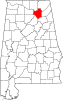
Marshall County is a county of the state of Alabama, United States. As of the 2020 census the population was 97,612. Its county seat is Guntersville. A second courthouse is in Albertville. Its name is in honor of John Marshall, famous Chief Justice of the United States. Marshall County is a dry county, with the exception of the four cities of Albertville, Arab, Guntersville, and Boaz. Marshall County comprises the Albertville, AL Micropolitan Statistical Area, which is also included in the Huntsville-Decatur-Albertville, AL Combined Statistical Area.

Marshall County is a county in the U.S. state of West Virginia. At the 2010 census, the population was 33,107. Its county seat is Moundsville. With its southern border at what would be a continuation of the Mason-Dixon line to the Ohio River, it forms the base of the Northern Panhandle of West Virginia.

Lineville is a city in Clay County, Alabama, United States. At the 2020 census, the population was 2,489.

Albertville is a city in Marshall County, Alabama, United States, and is included in the Huntsville-Decatur Combined Statistical Area. As of the 2020 census, the population of the city was 22,386. It is the largest city in Marshall County.

Clement Comer Clay was the eighth Governor of the U.S. state of Alabama from 1835 to 1837. An attorney, judge and politician, he also was elected to the state legislature, as well as to the House of Representatives and the US Senate.

Blakeley is a ghost town in Baldwin County, Alabama, United States. During the height of its existence, Blakeley was a thriving town which flourished as a competitor to its western neighbor, Mobile. Blakeley was the county seat for Baldwin County from 1820 until 1868, when the county government was moved south to Daphne. It was the location of a major fort during the Civil War. One of the last battles of the Civil War was fought here in April 1865, as Union soldiers overran Confederates. The town is now in an Alabama historic state park known as Historic Blakeley State Park, north of Spanish Fort.
Claysville is an unincorporated community in Harrison County, Kentucky, United States. It is located on U.S. Route 62 at the Licking River.
Claysville may refer to several places in the United States:

Kennamer Cove is an unincorporated community and cove in Marshall County, Alabama, United States. Kennamer Cove is located on the side of Gunters Mountain, and was first settled circa 1814 by the Kennamer family. Many of the inhabitants of the cove joined the Union Army during the American Civil War. Kennamer Cove is known regionally for hosting one of the largest family reunions in Alabama. Cathedral Caverns State Park and Kennamer Cave, a cave owned and preserved by the Southeastern Cave Conservancy Inc., are both located in Kennamer Cove.
Red Hill is an unincorporated community in Marshall County, Alabama, United States.
Warrenton is an unincorporated community in Marshall County, Alabama, United States.
Eddy is an unincorporated community in Marshall County, Alabama, United States. Eddy was most likely named for a local resident. A post office operated under the name Eddy from 1894 to 1907.
Echo, also known as Marshalls Cross Roads, is an unincorporated community in Dale County, Alabama, United States. Echo is located on Alabama State Route 27, 10.4 miles (16.7 km) east of Ozark.
Marlow is an unincorporated community in Baldwin County, Alabama, United States.
Claysville is an unincorporated community in Guernsey County, in the U.S. state of Ohio.
Claysville is an unincorporated community in Clay County, Missouri, United States.
SS W. P. Few was a Liberty ship built in the United States during World War II. She was named after Alexander S. Clay, a member of the Georgia House of Representatives and United States Senator from Georgia.

Milstead, also known as Cowles or Cowles Station, is an unincorporated community in Macon County, Alabama, United States.