Clayton, Staffordshire

Last updated

Clayton
Church of St James the Great in Clayton near Newcastle under Lyme - geograph.org.uk - 269105.jpg
Church of St James the Great in Clayton
Staffordshire UK location map.svg
Red pog.svg
Clayton
Location within Staffordshire
Population4,026 (2001 Census)
OS grid reference SJ849433
District
Shire county
Region
Country England
Sovereign state United Kingdom
Post town NEWCASTLE
Postcode district ST5
Dialling code 01782
Police Staffordshire
Fire Staffordshire
Ambulance West Midlands
UK Parliament
List of places
UK
England
Staffordshire
52°59′12″N2°13′33″W / 52.9868°N 2.2257°W / 52.9868; -2.2257

Clayton is a suburb and a ward in the Newcastle-under-Lyme district, in the county of Staffordshire, England.

Contents

Today

Clayton lies on the boundary between urban and rural Staffordshire, not far from Newcastle's border with the Borough of Stafford. The older part of the village stands on top of a hill, Northwood Lane, and some of these older houses were once gardeners' cottages on the Staffordshire estates of the Duke of Sutherland, who owned the Trentham Estate.

Towards Trent Vale is the Clayton Wood Training Ground and the football academy of Stoke City F.C.

Education

Clayton has one secondary school, Clayton Hall Academy. It has been developed on the site of the 19th century Clayton Hall and has around 1000 pupils [1] from all over Newcastle-under-Lyme. Until 2005 it was named Clayton High School. Then the school became a specialist school in Business & Enterprise and Modern Languages and was renamed Clayton Hall Business and Language College. The school converted to academy status in 2015 and was renamed again to Clayton Hall Academy.

Religion

The Catholic Church in Clayton is Our Lady and St Werburgh [2] which has over 500 regular worshippers and the primary school judged by Ofsted as 'outstanding' in every category. The parish runs three youth groups, an over 55s group, a parents and toddlers group, various parish house groups as well as running LinkLine. [3] LinkLine is a charity that rings up housebound elderly people for a regular weekly chat to show that they are loved and offer help in various ways.

There is also, based in the Parish Hall, one of the longest running Before and After School Clubs in the area, Wise Owls Care Club [4] which provides Before and After School Care and a Holiday Scheme for the children who attend the school.

Within Clayton is St James Church [5] which has a blue/green roof - originally copper, over the years with weather conditions has become this natural colour. This is an Anglican church where there is a Sunday School for children of any age. The school is held in the church hall at the same time as the main service is taken.

The Former United Reformed Church, Clayton United Reformed Church, Clayton - geograph.org.uk - 407949.jpg
The Former United Reformed Church, Clayton

Another nearby church is Newcastle Baptist Church (NBC). Rainbows, Brownies and Guides (Girlguiding) are held in the onsite community hall and Beavers, Cubs and Scouts are held in the den along with Explorers. These are held on a week night and there are two scout groups to go to; on Monday the Spitfires and Wednesday the Harriers. They were named after planes and are used to tell the two groups apart as they are both called 79th NBC Scouts. In Explorers the Duke of Edinburgh award can be taken. The site where the church is situated used to be part of the United Reformed Church before it changed to NBC in 2012. Since then, extensive work has been undertaken to create a new entrance and a community building at the rear of the site.

Other amenities

There is a hospital and a hotel on Clayton Rd (the A519).

The hospital is the Nuffield Health North Staffordshire Hospital. [6] It was opened in 1978 and is a purpose-built, well-equipped, private healthcare facility with two operating theatres, one minor/endoscopy suite and 40 en suite bedrooms.

Northwood Garden Centre, Clayton Northwood Garden Centre, Clayton Road - geograph.org.uk - 1225396.jpg
Northwood Garden Centre, Clayton

Close to Junction 15 of the M6 is the Holiday Inn [7]

There used to be another hotel next to the Nuffield Hospital called the Ramada Clayton Lodge Hotel, then called the Great National, Clayton. In 2017 it changed ownership and its name back to Clayton Lodge. It was not popular in Tripadvisor. It finally closed to guests in April 2020 and in 2021, a 'severe fire' broke out, causing serious damage and it then closed down for good. [8] In 2023 it was demolished. In 2024 the site is being redeveloped for 48 new homes. [9]

At the top of Northwood Lane are the Clayton Community Centre [10] which has two rooms for hire, (one for dancing and one for meetings) and the Northwood Garden Centre. [11] The Garden Centre has a café with a good view across to the bet365 Stadium

Civil parish

Clayton was formerly a township in the parish of Stoke-upon-Trent, [12] from 1896 Clayton was a civil parish in its own right, on 1 April 1932 the parish was abolished and merged with Newcastle under Lyme. [13] In 1931 the parish had a population of 264. [14]

Transport

Buses

A half-hourly Bus service is operated by D&G Bus (number 9).

Road

The A519 south to Eccleshall and Newport, Shropshire runs through Clayton between Newcastle-under-Lyme and the M6 motorway at junction 15, where the A500 (located on the southern outskirts of Clayton) runs to Stoke-on-Trent. To the west, in the nearby ward of the Westlands is the A53, which runs to Market Drayton and Shrewsbury.

Notable people

See also

Related Research Articles

<span class="mw-page-title-main">Staffordshire</span> County of England

Staffordshire is a landlocked ceremonial county in the West Midlands of England. It borders Cheshire to the north-west, Derbyshire and Leicestershire to the east, Warwickshire to the south-east, the West Midlands county and Worcestershire to the south, and Shropshire to the west. The largest settlement is the city of Stoke-on-Trent, and the county town is Stafford.

<span class="mw-page-title-main">Stoke-on-Trent</span> City and unitary authority in England

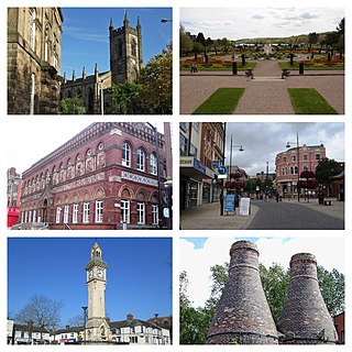
Stoke-on-Trent is a city and unitary authority area in Staffordshire, England, with an area of 36 square miles (93 km2). In 2021, the city had an estimated population of 258,400. It is the largest settlement in Staffordshire and is surrounded by the towns of Newcastle-under-Lyme, Alsager, Kidsgrove and Biddulph, which form a conurbation around the city.

<span class="mw-page-title-main">Newcastle-under-Lyme</span> Market town in Staffordshire, England

Newcastle-under-Lyme is a market town and the administrative centre of the Borough of Newcastle-under-Lyme in Staffordshire, England. It is adjacent to the city of Stoke-on-Trent. In 2021 the population was 75,082.

<span class="mw-page-title-main">Market Drayton</span> Town and civil parish in England

Market Drayton is a market town and civil parish on the banks of the River Tern in Shropshire, England. It is close to the Cheshire and Staffordshire borders. It is located between the towns of Whitchurch, Wem, Nantwich, Newcastle-under-Lyme, Newport and the city of Stoke on Trent. The town is on the Shropshire Union Canal and bypassed by the A53 road.

<span class="mw-page-title-main">Kidsgrove</span> Human settlement in England

Kidsgrove is a town in the borough of Newcastle-under-Lyme, Staffordshire, England, on the Cheshire border. It is part of the Potteries Urban Area, along with Stoke-on-Trent and Newcastle-under-Lyme. It has a population of 26,276. Most of the town is in the Kidsgrove ward, whilst the western part is in Ravenscliffe.

<span class="mw-page-title-main">Stone, Staffordshire</span> A Town in Staffordshire

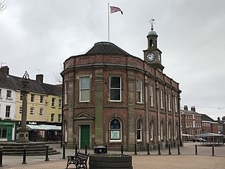
Stone is a market town and civil parish in Staffordshire, England, situated approximately 7 miles north of the county town of Stafford, 7 miles south of Stoke-on-Trent, and 15 miles north of Rugeley. As a notable canal town, Stone is recognised for its rich history, originating from the early Bronze Age and continuing through the Industrial Revolution, with the introduction of the Trent and Mersey Canal shaping the town's development and local industry.

<span class="mw-page-title-main">Borough of Newcastle-under-Lyme</span> Non-metropolitan district and borough in England

The Borough of Newcastle-under-Lyme is a local government district with borough status in Staffordshire, England.

<span class="mw-page-title-main">Keele</span> Village in Staffordshire, England

Keele is a village and civil parish in the Borough of Newcastle-under-Lyme in Staffordshire, England. It is approximately 3 miles (4.8 km) west of Newcastle-under-Lyme, and is close to the village of Silverdale. Keele lies on the A53 road from Newcastle to Market Drayton and Shrewsbury. The village is the location of Keele University and Keele Services, a motorway service area on the M6.

<span class="mw-page-title-main">Tunstall, Staffordshire</span> Human settlement in England

Tunstall is one of the six towns that, along with Burslem, Longton, Fenton, Hanley and Stoke-upon-Trent, amalgamated to form the City of Stoke-on-Trent in Staffordshire, England. It was one of the original six towns that federated to form the city. Tunstall is the most northern, and fourth largest town of the Potteries. It is situated in the very northwest of the city borough, with its north and west boundaries being the city limit. It stands on a ridge of land between Fowlea Brook to the west and Scotia Brook to the east, surrounded by old tile-making and brick-making sites, some of which date back to the Middle Ages.

<span class="mw-page-title-main">Barlaston</span> Human settlement in England

Barlaston is a village and civil parish in the borough of Stafford in the county of Staffordshire, England. It is roughly halfway between the city of Stoke-on-Trent and the small town of Stone. According to the 2001 census the population of the parish was 2,659, rising at the 2011 Census to 2,858.

<span class="mw-page-title-main">Trentham, Staffordshire</span> Human settlement in England

Trentham is a suburb of the city of Stoke-on-Trent in North Staffordshire, England, south-west of the city centre and south of the neighbouring town of Newcastle-under-Lyme. It is separated from the main urban area by open space and by the Trent and Mersey Canal and the River Trent, giving it the feel of a village.

<span class="mw-page-title-main">Betley</span> Human settlement in England

Betley is a village and civil parish in the borough of Newcastle-under-Lyme in Staffordshire, England, about halfway between the town of Newcastle-under-Lyme and Nantwich. Betley forms a continual linear settlement with Wrinehill.

<span class="mw-page-title-main">Audley, Staffordshire</span> Human settlement in England

Audley is a large village and former civil parish, now in the parish of Audley Rural, in the Newcastle-under-Lyme district, in Staffordshire, England. It is the centre of Audley Rural parish, approximately four miles north west of Newcastle-under-Lyme and 3 miles from Alsager near the Staffordshire-Cheshire border.

Sneyd Green is an area in the city of Stoke-on-Trent, Staffordshire, England, in the north-east of the city, 1.5 miles (2.4 km) from Hanley. Sneyd Green borders Smallthorne in the north, Milton in the east, Birches Head in the south, and Cobridge in the west.

Basford is a suburb which sits on high ground between Newcastle-under-Lyme and Stoke-on-Trent in Staffordshire, England.

Clayton Hall Academy is a mixed secondary school located in the Clayton area of Newcastle-under-Lyme in the English county of Staffordshire.

Kevin John Dunn was the twelfth Roman Catholic Bishop of Hexham and Newcastle.

<span class="mw-page-title-main">Tittensor</span> Human settlement in England

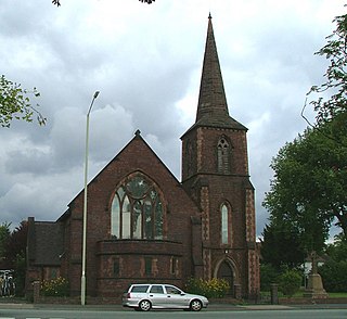
Tittensor village is located in Staffordshire, England, between Newcastle-under-Lyme and Stone. The population as taken at the 2011 census can be found under Swynnerton. The village consists of mostly 1960s housing as well as the few remaining houses from the 19th century. Historically Tittensor forms part of Stone parish. The Tittensor family occupied a manor house which passed to the Gerrard family sometime before 1405. The house was destroyed and rebuilt several times over the centuries, and was finally demolished in 1834. Some of the materials were used to build St Luke's church in Tittensor which was constructed in 1880-81. The ruins of the manor house remained until they were finally demolished in the early 1960s.

<span class="mw-page-title-main">Trent Vale</span> Human settlement in England

Trent Vale is a suburb located on the outskirts of Stoke-on-Trent in Staffordshire, England. It is bordered on the south by Hanford, to the west by Clayton, to the north by Newcastle-under-Lyme, to the southeast by Oakhill and Penkhull to the northeast. The ward it is under is called 'Springfields and Trent Vale'. The population of the ward at the 2011 census was 6,816.

References

  1. Clayton Hall Academy website retrieved Jan 2017
  2. The Catholic Parish of Our Lady & Saint Werburgh, Clayton website Archived 1 January 2017 at the Wayback Machine retrieved Jan 2017
  3. North Staffs LinkLine website retrieved Jan 2017
  4. Wise Owls Care Club Ltd website retrieved Jan 2017
  5. St James the Great Church, Clayton website retrieved Jan 2017
  6. Nuffield Newcastle website retrieved Jan 2017
  7. Holiday Inn website retrieved Jan 2017
  8. Castle, Richard; Jackson, Matt (3 April 2021). "Huge blaze rips through Staffordshire hotel overnight". burtonmail. Retrieved 18 September 2022.
  9. "Lion Court Homes; Westlands View" . Retrieved 27 March 2024.
  10. Council website retrieved Jan 2017
  11. Garden Centre Website retrieved June 2017
  12. "History of Clayton, in Newcastle under Lyme and Staffordshire". A Vision of Britain through Time . Retrieved 19 February 2023.
  13. "Relationships and changes Clayton CP through time". A Vision of Britain through Time. Retrieved 19 February 2023.
  14. "Population statistics Clayton CP through time". A Vision of Britain through Time. Retrieved 19 February 2023.
  15. "History of Clarice Cliff, one of the World's Most Influential Ceramics Artists". claricecliff.com. Retrieved 24 February 2017.
  16. The Very Reverend Raymond Furnell - Telegraph Retrieved 2011-04.
  17. Peter Gill at ESPNcricinfo
  18. "Britain's Eddie Hall defeats Game of Thrones star The Mountain to be crowned World's Strongest Man" . The Daily Telegraph. 28 May 2017. Archived from the original on 12 January 2022. Retrieved 28 May 2017.