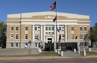
Tripp County is a county in the U.S. state of South Dakota. As of the 2020 census, the population was 5,624. Its county seat is Winner. The county was created in 1873, and was organized in 1909. It is named for lawyer, judge, and diplomat Bartlett Tripp.

Clearfield County is a county in the Commonwealth of Pennsylvania. As of the 2020 census, the population was 80,562. The county seat is Clearfield, and the largest city is DuBois. The county was created in 1804 and later organized in 1822.

Griggs County is a county in the U.S. state of North Dakota. As of the 2020 census, the population was 2,306. Its county seat is Cooperstown.

Clearfield is a borough and the county seat of Clearfield County, Pennsylvania, United States. As of the 2020 census the population was 5,962 people, making it the second most populous community in Clearfield County, behind DuBois. The borough is part of the DuBois, PA Micropolitan Statistical Area, as well as the larger State College-DuBois, PA Combined Statistical Area. The settled area surrounding the borough consists of the nearby census-designated places of Hyde and Plymptonville, which combined with Clearfield have a population of approximately 8,237 people.

Clearfield is a city in Davis County, Utah, United States. The population was 31,364 at the 2020 census. The city grew rapidly during the 1940s, with the formation of Hill Air Force Base, and in the 1950s with the nationwide increase in suburb and "bedroom" community populations and has been steadily growing since then.
Clearfield Township is the name of some townships in the United States:
Clearfield Township is a township in Griggs County, North Dakota, United States.
Clearfield Trust Co. v. United States, 318 U.S. 363 (1943), was a case in which the Supreme Court of the United States held that federal negotiable instruments were governed by federal law, and thus the federal court had the authority to fashion a common law rule.
West Decatur is an unincorporated community and census-designated place in Clearfield County, Pennsylvania, United States. As of the 2020 census the population of West Decatur was 453.
Oak Ridge is an unincorporated community in Clearfield County, Pennsylvania, United States. The community is 8.8 miles (14.2 km) south of Curwensville.
Luthersburg is an unincorporated community in Clearfield County, Pennsylvania, United States. The community is located at the intersection of U.S. routes 219 and 322, and Pennsylvania Route 410, 5.1 miles (8.2 km) south-southeast of DuBois. Luthersburg has a post office, with ZIP code 15848.
Viola is an unincorporated community in Gulich Township, Clearfield County, Pennsylvania, United States. The community is located at the intersection of state routes 153, 253 and 453, 5.7 miles (9.2 km) south-southwest of Houtzdale.
Clearfield is an unincorporated community in Rowan County, Kentucky, United States. The community is located along Kentucky Route 519 1.5 miles (2.4 km) south of Morehead. Clearfield has a post office with ZIP code 40313.
Morann is an unincorporated community in Clearfield County, Pennsylvania, United States. The community is located along Pennsylvania Route 153, 2.8 miles (4.5 km) south-southwest of Houtzdale. Morann has a post office with ZIP code 16663, which opened on June 19, 1890.
Olanta is an unincorporated community in Clearfield County, Pennsylvania, United States. The community is located along Pennsylvania Route 453, 4.2 miles (6.8 km) south-southeast of Curwensville. Olanta has a post office, with ZIP code 16863.
The Pennsylvania State Game Lands Number 60 are Pennsylvania State Game Lands in Blair, Centre and Clearfield Counties in Pennsylvania in the United States providing hunting, bird watching, and other activities.
Newtonburg is an unincorporated community in Clearfield County, Pennsylvania, United States.
Kingsley Township is a township in Griggs County, North Dakota, United States.
Clearfield Colony is a Hutterite colony and census-designated place (CDP) within the Yankton Indian Reservation in Charles Mix County, South Dakota, United States. It was first listed as a CDP prior to the 2020 census. The population of the CDP was 99 at the 2020 census.


