Clifton, West Yorkshire

Last updated

Clifton
St John's Church, Clifton - geograph.org.uk - 1081220.jpg
St John's Church
Calderdale UK location map.svg
Red pog.svg
Clifton
West Yorkshire UK location map.svg
Red pog.svg
Clifton
Location within West Yorkshire
OS grid reference SE159229
Metropolitan borough
Metropolitan county
Region
Country England
Sovereign state United Kingdom
Post town Brighouse
Postcode district HD6
Dialling code 01484
Police West Yorkshire
Fire West Yorkshire
Ambulance Yorkshire
UK Parliament
List of places
UK
England
Yorkshire
53°42′08″N1°45′38″W / 53.7023°N 1.7606°W / 53.7023; -1.7606

Clifton is a village on the eastern outskirts of Brighouse in the Calderdale district of West Yorkshire, England.

Contents

History

Clifton is mentioned as Cliftone in the Domesday book The entry reads ‘In Cliftone Escelf has seven carucates of land…where four ploughs may be…’The manor was one of two hundred manors granted by William the Conqueror to the Norman noble, Ilbert de Laci. The early Lords of the Manor lived at Clifton Hall (which was down Well Lane) and Cross Hall (later called Highley Hall). Remnants of the early ‘strip’ farming remain in the fields known as ‘The Acres’.

Clifton was historically a chapelry in the ancient parish of Dewsbury. It became a separate civil parish in 1866. [1] From 1837 it formed part of the Halifax Poor Law Union and therefore became part of the Halifax Rural District when it was created in 1894. [2] The parish of Clifton was abolished in 1937. Most of the parish, including the village itself, was added to the parish and Municipal Borough of Brighouse. Smaller areas were transferred to the parishes of Cleckheaton and Liversedge in the urban district of Spenborough. [3] The borough of Brighouse was abolished in 1974, becoming part of Calderdale. No successor parish was created for the former borough and so Clifton is directly administered by Calderdale Council.

Governance

Clifton is a village in the Brighouse ward of Calderdale, a metropolitan borough in the ceremonial county of West Yorkshire, England. [4]

Geography

The village is on the north side of the valley of the River Calder and the plateau adjoining it.

The village is on the route of the Calderdale Way. This is a 50-mile circular walk around the hills and valleys of Calderdale. [5]

Nearby towns and villages

Culture and community

Wakefield Road, Clifton, West Yorkshire Filling Station, Wakefield Road (A644), Clifton - geograph.org.uk - 1211468.jpg
Wakefield Road, Clifton, West Yorkshire

There are two public houses at either end of the main street (Towngate). One, the Black Horse Inn, was the Yorkshire Post pub restaurant of 2006. The other is the Armytage Arms. Clifton also has a small hairdressing salon.

The Clifton Village Community Association (CVCA) organises local events, in recent years has added a new memorial stone to men lost in WWII associated with Clifton Village war memorial railings and the village play park. In addition to restoring and managing the former telephone kiosk, the CVCA has oversight of local issues. [6]

The Clifton Village Neighbourhood Forum (CVNF) [7] was granted recognition by Calderdale Council on 1 August 2018 to produce a neighbourhood plan for Clifton Village. [8]

Clifton also gives its name to the Clifton & Lightcliffe brass band. It is one of the country's oldest, formed in 1838.[ citation needed ] The band headquarters is in nearby Bailiff Bridge.

Landmarks

There are many local historical references connected to drift mining. It was first recorded in 1307 and also mentioned by Daniel Defoe, author of Robinson Crusoe , in his 1727 book 'A Tour Of Great Brittain'. On the western flank of the village is a long straight ridge, which constitutes the remains of a gravity railway that was last used to transport coal in 1920 to the municipal gasworks by the Calder and Hebble Navigation at Brighouse.

There are also intriguing historical connections such as America Lane, the fever hospital and Clifton 'airport' used by Sir Alan Cobham's Air Circus between the two world wars. The remains of the village well can be seen opposite the school.

At the easterly edge of the village is the 16th-century Kirklees Hall, whose grounds contain the reputed grave of Robin Hood. It was the model for 'Nunwood' in Charlotte Brontë's novel 'Shirley'. At the northerly end of the village, there remains evidence of strip farming, also known as 'open field system'. Originally, there were 32 strips of land and families would work two or three. Beyond were fields known as the Doles, common grazing land.

Doles Lane, a public right of way, still exists and starts (as Well Lane), opposite the Black Horse Inn a meeting place for Luddites, the machine wreckers, in the early 19th century. Highley Hall (formerly Crosse Hall), near the war memorial, was a farm until the 1990s. Originally the family home of Richard de Hileagh, constable of the village in the mid-14th century; it is now again a private residence.

Education

Clifton School viewed from across the recreation ground. CliftonSchoolViewedFromSouthEast.jpg
Clifton School viewed from across the recreation ground.

The village, a 'Village Design Statement' area, has a junior and infant school, St John's Primary Academy, originally built in the 1870s. It is a top-performing school, which was called 'outstanding' in successive Ofsted inspections such as in 2014. It was 7th best in England for SATS level 5 in December 2007. The academy has had many names, but was first called Clifton School, but now it is called St. John's CE Primary Academy, Clifton.

Religious sites

There is an Anglican church (first baptism Goldthorpe Squire 1859, first burial Zillah Ramsden 1860) within the Church of England Diocese of Leeds, and a Methodist church. Patrick Brontë, father of the novelist sisters, was Minister at the nearby Hartshead-cum-Clifton church.

Sport

Adjacent to the village is Willow Valley Golf Club. Each June, the club hosts the annual Yorkshire PGA Championship.

See also

Related Research Articles

<span class="mw-page-title-main">Brighouse</span> Town in West Yorkshire, England

Brighouse is a town within the metropolitan borough of Calderdale, in West Yorkshire, England. Historically within the West Riding of Yorkshire, it is situated on the River Calder, 4 miles (6.4 km) east of Halifax. It is served by Junction 25 of the M62 motorway and Brighouse railway station on the Caldervale Line and Huddersfield Line. In the town centre is a mooring basin on the Calder and Hebble Navigation. The United Kingdom Census 2001 gave the Brighouse / Rastrick subdivision of the West Yorkshire Urban Area a population of 32,360. The Brighouse ward of Calderdale Council gave a population of 11,195 at the 2011 Census. Brighouse has a HD6 postcode.

<span class="mw-page-title-main">Elland</span> Town in West Yorkshire, England

Elland is a market town in Calderdale, in the county of West Yorkshire, England. It is situated south of Halifax, by the River Calder and the Calder and Hebble Navigation. Elland was recorded as Elant in the Domesday Book of 1086. It had a population in 2001 of 14,554, with the ward being measured at 11,676 in the 2011 Census.

<span class="mw-page-title-main">Rastrick</span> Village in West Yorkshire, England

Rastrick is a village in the county of West Yorkshire, England, between Halifax, 5 miles (8 km) north-east and Huddersfield, 4 miles (7 km) south.

<span class="mw-page-title-main">Sowerby Bridge</span> Market town in West Yorkshire, England

Sowerby Bridge is a market town in the Upper Calder Valley in Calderdale in West Yorkshire, England. The Calderdale Council ward population at the 2011 census was 11,703.

<span class="mw-page-title-main">Hartshead</span> Village in West Yorkshire, England

Hartshead is a village in the Kirklees district of West Yorkshire, England, 3.7 miles (6 km) west of Dewsbury and near to Hartshead Moor.

<span class="mw-page-title-main">Calderdale</span> Metropolitan borough in West Yorkshire, England

Calderdale is a metropolitan borough of West Yorkshire, England, which had a population of 211,439. It takes its name from the River Calder, and dale, a word for valley. The name Calderdale usually refers to the borough through which the upper river flows, while the actual landform is known as the Calder Valley. Several small valleys contain tributaries of the River Calder. The main towns of the borough are Brighouse, Elland, Halifax, Hebden Bridge, Sowerby Bridge and Todmorden.

<span class="mw-page-title-main">Calder Valley (UK Parliament constituency)</span> Parliamentary constituency in the United Kingdom

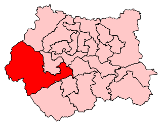
Calder Valley is a constituency in West Yorkshire represented in the House of Commons of the UK Parliament since 2010 by Craig Whittaker, a Conservative.

<span class="mw-page-title-main">Luddenden</span> District of Calderdale, West Yorkshire, England

Luddenden is a district of Calderdale 3.1 miles (5 km) west of Halifax on the Luddenden Brook in the county of West Yorkshire, England.

<span class="mw-page-title-main">Warley Town</span> Human settlement in England

Warley Town is a settlement near Halifax, in the Calderdale district, in the county of West Yorkshire, England. Warley is a ward of Calderdale. The population of this ward as taken at the 2011 Census was 12,215.

<span class="mw-page-title-main">Hebden Royd</span> Town and Civil Parish in West Yorkshire, England

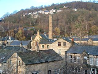
Hebden Royd is a civil parish in the Metropolitan Borough of Calderdale in West Yorkshire, England. According to the 2001 census it had a population of 9,092, rising to 9,558 at the 2011 census. It includes market town of Hebden Bridge and the villages of Mytholmroyd and Cragg Vale. The parish was an urban district before 1974, created in 1937 by the merger of Hebden Bridge and Mytholmroyd urban districts.

<span class="mw-page-title-main">Salterhebble</span> Area of Halifax, West Yorkshire, England

Salterhebble is an area of Halifax, a town within the Metropolitan Borough of Calderdale, in West Yorkshire, England. The town falls within the Skircoat ward of Calderdale Council. Salterhebble is located where the Hebble Brook flows into the River Calder. It is on the main route into Halifax from Huddersfield and Brighouse. Salterhebble is the home of Calderdale Royal Hospital, a school, a fast food restaurant, a funeral parlour and one active pub, The Watermill. Some former pubs in the village included The Punch Bowl, The Falcon and The Stafford Arms.

<span class="mw-page-title-main">Sowerby, West Yorkshire</span> Village in West Yorkshire, England

Sowerby is a village in the Metropolitan Borough of Calderdale, in West Yorkshire, England. It lies in the Pennines, contiguous with Sowerby Bridge, 3.7 miles (6.0 km) west-southwest of Halifax.

<span class="mw-page-title-main">Southowram</span> Village in West Yorkshire, England

Southowram is a village and former civil parish in Calderdale, West Yorkshire, England. It stands on hill top between Halifax and Brighouse, on the south side of the Shibden Valley. Northowram is on the northern side of the valley. Southowram falls within the Town ward of Calderdale Council. The village is included within the Halifax built-up area as defined by the Office for National Statistics.

<span class="mw-page-title-main">Hipperholme</span> Village in West Yorkshire, England

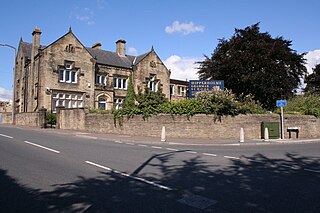
Hipperholme is a village in West Yorkshire, England, located between the towns of Halifax and Brighouse in the Hipperholme and Lightcliffe ward of the Metropolitan Borough of Calderdale. The population of this ward at the 2011 Census was 11,308.

<span class="mw-page-title-main">Halifax, West Yorkshire</span> Town in West Yorkshire, England

Halifax is a town in the Metropolitan Borough of Calderdale, in West Yorkshire, England. It is near the east Pennine foothills. In the 15th century, the town became an economic hub of the old West Riding of Yorkshire, primarily in woollen manufacture with the large Piece Hall square later built for trading wool in the town centre. The town was a thriving mill town during the Industrial Revolution with the Dean Clough Mill buildings a surviving landmark. In 2011, it had a population of 88,134. It is also the administrative centre of the wider Calderdale Metropolitan Borough.

<span class="mw-page-title-main">Municipal Borough of Brighouse</span>

The Municipal Borough of Brighouse was a local government district in the West Riding of Yorkshire from 1873 to 1974 around the town of Brighouse, covering Clifton, Hipperholme, Hove Edge, Lightcliffe, Rastrick and Southowram.

<span class="mw-page-title-main">William Swinden Barber</span> English architect (1832–1908)

William Swinden Barber FRIBA, also W. S. Barber or W. Swinden Barber, was an English Gothic Revival and Arts and Crafts architect, specialising in modest but finely furnished Anglican churches, often with crenellated bell-towers. He was based in Brighouse and Halifax in the West Riding of Yorkshire. At least 15 surviving examples of his work are Grade II listed buildings, including his 1875 design for the Victoria Cross at Akroydon, Halifax. An 1864 portrait by David Wilkie Wynfield depicts him in Romantic garb, holding a flower. He served in the Artists Rifles regiment in the 1860s alongside Wynfield and other contemporary artists.

Brighouse is a town and an unparished area in the metropolitan borough of Calderdale, West Yorkshire, England. It contains 71 listed buildings that are recorded in the National Heritage List for England. Of these, two are listed at Grade I, the highest of the three grades, six are at Grade II*, the middle grade, and the others are at Grade II, the lowest grade. This list contains the listed buildings in Brighouse Ward which, in addition to the town of Brighouse, contains the village of Clifton and the surrounding countryside, in particular to the west and the southeast of the town along the valley of the River Calder. Historically, one of the most important buildings in the area was Kirklees Priory, which has been demolished, but listed buildings associated with it remain, in particular farm buildings in Home Farm and a gatehouse. In addition to the River Calder, the Calder and Hebble Navigation runs through the area, and listed buildings associated with the two waterways include bridges, locks, lock keepers' houses, a warehouse, and a milestone. The other listed buildings include houses and associated structures, cottages, farmhouses and farm buildings, shops and offices, churches and chapels, two graves, a sundial, a former mill, a former school, civic buildings, banks, a railway bridge, road milestones, a boundary stone, a folly, and a war memorial.

<span class="mw-page-title-main">Stansfield, West Yorkshire</span> Human settlement in Todmorden, West Yorkshire, England

Stansfield is a place and township in the civil parish of Todmorden and Metropolitan Borough of Calderdale, in West Yorkshire, England, which gave its name to Stansfield Hall, Stansfield Hall Railway Station, and an electoral ward in Todmorden, Calderdale.

References

  1. "Relationships and changes Clifton Ch/CP through time". A Vision of Britain through Time. Retrieved 11 August 2023.
  2. Higginbotham, Peter. "Halifax Workhouse". The Workhouse. Retrieved 5 September 2023.
  3. "Halifax Registration District". 2011. Retrieved 26 February 2012.
  4. "Brighouse". 2010. Retrieved 26 February 2012.
  5. http://www.crewheartsupport.co.uk/calderdaleway Archived 24 April 2014 at the Wayback Machine .
  6. "The CVCA – Clifton Village Community Association" . Retrieved 29 November 2020.
  7. "Clifton Village Neighbourhood Forum – Clifton – West Yorkshire".
  8. "Neighbourhood Development Plans (NDPs) | Calderdale Council".