Climate of Africa

Last updated

Climate zones of Africa, showing the ecological break between the Sahara Desert (red), the hot semi-arid climate of the Sahel (orange) and the tropical climate of Central and Western Africa (blue). Southern Africa has a transition to subtropical and temperate climates (green and yellow), and more desert or semi-arid regions, centered on Namibia, Botswana, and South Africa. Koppen-Geiger Map Africa present.svg
Climate zones of Africa, showing the ecological break between the Sahara Desert (red), the hot semi-arid climate of the Sahel (orange) and the tropical climate of Central and Western Africa (blue). Southern Africa has a transition to subtropical and temperate climates (green and yellow), and more desert or semi-arid regions, centered on Namibia, Botswana, and South Africa.
A map of Africa showing the ecological break around the Sahara Desert Africa satellite orthographic.jpg
A map of Africa showing the ecological break around the Sahara Desert

The climate of Africa is a range of climates such as the equatorial climate, the tropical wet and dry climate, the tropical monsoon climate, the semi-arid climate (semi-desert and steppe), the desert climate (hyper-arid and arid), the humid subtropical climate, and the subtropical highland climate. Temperate climates are rare across the continent except at very high elevations and along the fringes. In fact, the climate of Africa is more variable by rainfall amount than by temperatures, which are consistently high. African deserts are the sunniest and the driest parts of the continent, owing to the prevailing presence of the subtropical ridge with subsiding, hot, dry air masses. Africa holds many heat-related records: the continent has the hottest extended region year-round, the areas with the hottest summer climate, the highest sunshine duration, and more.

Contents

Owing to Africa's position across equatorial and subtropical latitudes in both the northern and southern hemisphere, several different climate types can be found within it. The continent mainly lies within the intertropical zone between the Tropic of Cancer and the Tropic of Capricorn, hence its interesting density of humidity. Precipitation intensity is always high, and it is a hot continent. Warm and hot climates prevail all over Africa, but mostly the northern part is marked by aridity and high temperatures. Only the northernmost and the southernmost fringes of the continent have a Mediterranean climate. The equator runs through the middle of Africa, as do the Tropic of Cancer and the Tropic of Capricorn, making Africa the most tropical continent.

Temperatures

Monthly mean and minimum outdoor and indoor temperatures throughout Africa Africa temperature.png
Monthly mean and minimum outdoor and indoor temperatures throughout Africa

Globally, heating of the earth near the equator leads to large amounts of upward motion and convection along the monsoon trough or Intertropical Convergence Zone. The divergence over the near-equatorial trough leads to air rising and moving away from the equator aloft. As it moves towards the Mid-Latitudes, the air cools and sinks, which leads to subsidence near the 30th parallel of both hemispheres. This circulation is known as the Hadley cell and leads to the formation of the subtropical ridge. [2] Many of the world's deserts are caused by these climatological high-pressure areas, [3] including the Sahara Desert.

Temperatures are hottest within the Sahara regions of Algeria and Mali, [4] and coolest across the south and at elevation within the topography across the eastern and northwest sections of the continent. The hottest average temperature on Earth is at Dallol, Ethiopia, which averages a temperature of 33.9 °C (93.0 °F) throughout the year. [5] The hottest temperature recorded within Africa, which was also the world record, was 57.8 °C (136.0 °F) at 'Aziziya, Libya, on 13 September 1922. This was later proven to be false, being derived from an inaccurate reading of a thermometer. The world's hottest place is in fact Death Valley, in California. [6] [7] [8] Apparent temperatures, combining the effect of the temperature and humidity, along the Red Sea coast of Eritrea and Gulf of Aden coast of Somalia range between 57 °C (135 °F) and 63 °C (145 °F) during the afternoon hours. [4] The lowest temperature measured within Africa was −24 °C (−11 °F) at Ifrane, Morocco, on 11 February 1935. [9] Nevertheless, the major part of Africa experiences extreme heat during much of the year, especially the deserts, semi-deserts, steppes and savannas. The African deserts are arguably the hottest places on Earth, especially the Sahara Desert and the Danakil Desert, located in the Horn of Africa.

Wind

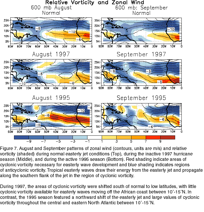
The mid-level African easterly jet stream north of the equator is considered to play a crucial role in the West African monsoon, [10] and helps form the tropical waves which march across the tropical Atlantic and the eastern part of the Pacific during the warm season. [11] The jet exhibits both barotropic and baroclinic instability, which produces synoptic-scale, westward-propagating disturbances in the jet known as African easterly waves, or tropical waves. A small number of mesoscale storm systems embedded in these waves develop into tropical cyclones after they move from west Africa into the tropical Atlantic, mainly during August and September. When the jet lies south of normal during the peak months of the Atlantic hurricane season, tropical cyclone formation is suppressed. [12]

Low-level jets are fast winds which form close to the surface (within 1.5 km). They affect a number of climate processes across Africa. The Somali Low-level Jet, [13] which forms of the coast of East Africa, contributes to the existence of the Somali Desert. [14] [15] Low-level jets of the Sahara are known to be important for raising dust off the dry desert surface. For example, the low-level jet over Chad, [16] is the driver of dust emission from the Bodélé Depression, the largest source of atmospheric dust on the planet. [17] Easterly low-level jets which form in river valleys across the East African Rift System supply millions of tonnes of water vapour originating from the Indian Ocean across East Africa and to the Congo rainforest. [18] In doing so, they leave East Africa unusually dry for its latitude. [19] Low-level southwesterlies emanating from the Gulf of Guinea are the key moisture source for the West African monsoon in northern hemisphere summer. [20]

The Tropical Easterly Jet, which forms high up in the atmosphere, 15-17 km above the surface, is another important factor. Variations to the speed and position of this jet stream can affect rainfall in the Congo Basin and the Sahel. [21]

Precipitation

Mean precipitation map Africa Precipitation Map.svg
Mean precipitation map

Great parts of North Africa and Southern Africa as well as the whole Horn of Africa mainly have a hot desert climate, or a hot semi-arid climate for the wetter locations. The Sahara Desert in North Africa is the largest hot desert in the world and is one of the hottest, driest and sunniest places on Earth. Located just south of the Sahara is a narrow semi-desert steppe (a semi-arid region) called the Sahel, while Africa's most southern areas contain both savanna plains, and its central portion, including the Congo Basin, contains very dense jungle (rainforest) regions. The western equatorial region is the wettest portion of the continent. Annually, the rain belt across the continent moves northward into Sub-Saharan Africa by August, then passes back southward into south-central Africa by March. [22] Areas with a savannah climate in Sub-Saharan Africa, such as Ghana, Burkina Faso, [23] [24] Darfur, [25] Eritrea, [26] Ethiopia, [27] and Botswana have a distinct rainy season. [28] El Nino results in drier-than-normal conditions in Southern Africa from December to February, and wetter-than-normal conditions in equatorial East Africa over the same period. [29]

In Madagascar, trade winds bring moisture up the eastern slopes of the island, which is deposited as rainfall, and bring drier downsloped winds to areas south and west, leaving the western sections of the island in a rain shadow. This leads to significantly more rainfall over northeast sections of Madagascar than its southwestern portions. [30] Southern Africa receives most of its rainfall from summer convective storms, tropical lows, mesoscale convective systems. Extratropical cyclones moving through the Westerlies, can also bring significant winter rainfall. Once a decade, tropical cyclones lead to excessive rainfall across the region. [31]

Snow and glaciers

Snow in the Atlas Mountains in Morocco Atlas Mountains snow cover.jpg
Snow in the Atlas Mountains in Morocco

Snow is an almost annual occurrence on some of the mountains of South Africa, including those of the Cedarberg and around Ceres in the South-Western Cape, and on the Drakensberg in Natal and Lesotho. Tiffendell Resort, in the Drakensberg, is the only commercial ski resort in South Africa, and has "advanced snow-making capability" allowing skiing for three months of the year. [32] The Mountain Club of South Africa (MCSA) and the Mountain and Ski Club (MSC) [33] of the University of Cape Town both have equipped ski huts in the Hex River mountains. Skiing including snowboarding in the Cape is a hit-and-miss affair, both in terms of timing of snowfalls, and whether there is sufficient snow to cover the rocks.

Table Mountain gets a light dusting of snow on the Front Table and also at Devil's Peak every few years. Snowfalls on Table Mountain took place on 20 September 2013; [34] 30 August 2013; [35] 5 August 2011; [36] and on 15 June 2010. [37]

Snow is a rare occurrence in Johannesburg; it fell in May 1956, August 1962, June 1964, September 1981, August 2006, and on 27 June 2007, [38] accumulating up to 10 centimetres (3.9 in) in the southern suburbs.

Additionally, snow regularly falls in the Atlas Mountains in the Maghreb, as well as the Mediterranean regions and Sinai peninsula of Egypt. Snowfall is also a regular occurrence at Mount Kenya and Mount Kilimanjaro in Tanzania.

There have been permanent glaciers on the Rwenzori Mountains, on the border of Uganda and the Democratic Republic of the Congo. However, by the 2010s, the glaciers were in retreat, and they are under threat of disappearing through rising temperatures. [39]

Climate change

Graph showing temperature change in Africa between 1901 and 2021, with red colour being warmer and blue being colder than average (the average temperature during 1971-2000 is taken as the reference point for these changes). Temperature Bar Chart Africa--1901-2020--2021-07-14.png
Graph showing temperature change in Africa between 1901 and 2021, with red colour being warmer and blue being colder than average (the average temperature during 1971–2000 is taken as the reference point for these changes).

Climate change in Africa is an increasingly serious threat as Africa is among the most vulnerable continents to the effects of climate change. [40] [41] [42] Some sources even classify Africa as "the most vulnerable continent on Earth". [43] [44] Climate change and climate variability will likely reduce agricultural production, food security and water security. [45] As a result, there will be negative consequences on people's lives and sustainable development in Africa. [41]

Over the coming decades, warming from climate change is expected across almost all the Earth's surface, and global mean rainfall will increase. [46] Currently, Africa is warming faster than the rest of the world on average. Large portions of the continent may become uninhabitable as a result of the rapid effects of climate change, which would have disastrous effects on human health, food security, and poverty. [47] [48] [49] Regional effects on rainfall in the tropics are expected to be much more spatially variable. The direction of change at any one location is often less certain.

Observed surface temperatures have generally increased by about 1 °C in Africa since the late 19th century to the early 21st century. [50] In the Sahel, the increase has been as much as 3 °C for the minimum temperature at the end of the dry season. [50] Data for temperature and rainfall shows discrepancies from the norm, both in timing and location. [51] [41] [52]

For instance, Kenya has a high vulnerability to the impacts of climate change. The main climate hazards include droughts and floods as rainfall will likely become more intense and less predictable. Climate models predict that temperatures will rise by 0.5 to 2 °C. [53] In the informal urban settlements of Nairobi the urban heat island effect adds to the problem as it creates even warmer ambient temperatures. This is due to home construction materials, lack of ventilation, sparse green space, and poor access to electrical power and other services. [54]

The African Union has put forward 47 goals and corresponding actions in a 2014 draft report to combat and mitigate climate change in Africa. [55] The International Monetary Fund suggested in 2021 that $50 billion might be necessary to cover the costs of climate change adaptation in Africa. [56] [57] [58]

In chapter 9 of the IPCC Sixth Assessment Report, it is reported that although greenhouse gas emissions are among the lowest in Africa, anthropogenic climate change has severely threatened daily life. People experience extreme food insecurity, high mortality rates, major biodiversity loss, and more as a result of global warming. Additionally, because of reduced economic activity and growth and inequities in funding, the ability for adaptation to these conditions is also reduced. [59]

Severe weather

Satellite image of Cyclone Kenneth in 2019 striking Mozambique Kenneth 2019-04-25 0745Z.jpg
Satellite image of Cyclone Kenneth in 2019 striking Mozambique

Tornadoes

Tornadoes can occur regularly in South Africa along the eastern coast with the Indian Ocean. [60]

Tropical cyclones

Powerful tropical cyclones regularly affect southeastern Africa. On average, 1.5 tropical cyclones strike Madagascar each year, which is the most affected area in Africa. [61] In March 1927, a tropical cyclone struck eastern Madagascar, killing at least 500 people. [62] In March 2004, Cyclone Gafilo hit northeastern Madagascar as one of the island's strongest ever cyclones, killing 363 people, leaving US$250 million in damage. [63] [64] In March 2019, Cyclone Idai hit central Mozambique and killed 1,302 people across Southern Africa, – affecting more than 3 million people. Total damages from Idai across Mozambique, Zimbabwe, Madagascar, and Malawi were estimated to be at least $2.2 billion (2019 USD). [65] [66] Roughly one month later, Cyclone Kenneth struck northern Mozambique as the country's strongest ever landfall. [67] In 2020, Cyclone Freddy struck Mozambique in two different locations, producing widespread rainfall that killed 1,434 people along its path, mostly in Malawi. [68] [69]

Occasionally, cyclones in the Mediterranean can affect northern Africa, and which also have characteristics of a tropical cyclone. In September 2023, Storm Daniel moved ashore Libya and produced heavy rainfall, producing flash flooding after two dams failed. The storm killed at least 4,333 people in the country, becoming the deadliest storm to hit Africa in recorded history. [70] [71] In September 1969, a cyclone in the Mediterranean Sea killed nearly 600 people in Tunisia and Libya. [72] Cyclones from the Indian Ocean can strike the Horn of Africa. In November 2013, a deep depression struck Somalia and killed 162 people while also causing extensive livestock damage. [73] [74] [75] The temperature contrast between the hot Sahara Desert in northern Africa and the cooler Gulf of Guinea to the south produces the African easterly jet, which generates tropical waves, or an elongated area of low pressure. These waves are often the formation source of Atlantic and Pacific hurricanes. [76]

See also

Related Research Articles

<span class="mw-page-title-main">Geography of Mali</span>

Mali is a landlocked nation in West Africa, located southwest of Algeria, extending south-west from the southern Sahara Desert through the Sahel to the Sudanian savanna zone. Mali's size is 1,240,192 square kilometers.

<span class="mw-page-title-main">Extreme weather</span> Unusual, severe or unseasonal weather

Extreme weather includes unexpected, unusual, severe, or unseasonal weather; weather at the extremes of the historical distribution—the range that has been seen in the past. Extreme events are based on a location's recorded weather history. They are defined as lying in the most unusual ten percent. The main types of extreme weather include heat waves, cold waves and heavy precipitation or storm events, such as tropical cyclones. The effects of extreme weather events are economic costs, loss of human lives, droughts, floods, landslides. Severe weather is a particular type of extreme weather which poses risks to life and property.

The climate of Mumbai is tropical, with defined wet and dry seasons. The mean annual temperature is 27.7 °C or 81.9 °F. Average annual rainfall is 2,213.4 millimetres or 87 inches in Colaba, which represents South Mumbai and 2,502.3 millimetres or 99 inches in Santacruz, which represents central and suburban Mumbai. The mean maximum average temperatures is about 32 °C (90 °F) in summer and 30 °C (86 °F) in winter, while the average minimums are 26 °C (79 °F) in summer and 18 °C (64 °F) in winter. The city experiences a lengthy, practically rainless dry season, and a relatively short, but extremely rainy wet season; due to the Southwest Monsoon and orographic influences from the nearby Western Ghats.

<span class="mw-page-title-main">Climate of India</span> Overview of climatic conditions in India

The climate of India consists of a wide range of weather conditions across a vast geographic scale and varied topography. Based on the Köppen system, India hosts six major climatic sub types, ranging from arid deserts in the west, alpine tundra and glaciers in the north, and humid tropical regions supporting rain forests in the southwest and the island territories. Many regions have starkly different microclimates, making it one of the most climatically diverse countries in the world. The country's meteorological department follows the international standard of four seasons with some local adjustments: winter, summer, monsoon or rainy season, and a post-monsoon period.

This is a list of meteorology topics. The terms relate to meteorology, the interdisciplinary scientific study of the atmosphere that focuses on weather processes and forecasting.

<span class="mw-page-title-main">Climate of Puerto Rico</span> Predominantly tropical rainforest in the Köppen climate classification

The climate of Puerto Rico in the Köppen climate classification is predominantly tropical rainforest. Temperatures throughout the year are warm to hot, averaging near 85 °F (29 °C) in lower elevations and 70 °F (21 °C) in the mountains. Easterly trade winds pass across the island year round while the rainy season stretches from April into November. The relatively cool trade winds are blocked by the mountains of the Cordillera Central which causes rain shadows and sharp variations in the temperature and wind speed over short distances. About a quarter of the average annual rainfall for Puerto Rico occurs during tropical cyclones, which are more frequent during La Niña years.

The climate of San Diego, California is classified as a hot-summer Mediterranean climate. The basic climate features hot, sunny, and dry summers, and cooler, wetter winters. However, San Diego is much more arid than typical Mediterranean climates, and winters are still dry compared with most other zones with this type of climate. The climate at San Diego International Airport, the location for official weather reports for San Diego, as well as the climate at most beach areas, straddles the border between BSh and BSk due to the mild winters and cool summers in these locations.

<span class="mw-page-title-main">United States rainfall climatology</span> Characteristics of weather in U.S.

The characteristics of United States rainfall climatology differ significantly across the United States and those under United States sovereignty. Summer and early fall bring brief, but frequent thundershowers and tropical cyclones which create a wet summer and drier winter in the eastern Gulf and lower East Coast. During the winter, and spring, Pacific storm systems bring Hawaii and the western United States most of their precipitation. Low pressure systems moving up the East Coast and through the Great Lakes, bring cold season precipitation to from the Midwest to New England, as well as Great Salt Lake. The snow to liquid ratio across the contiguous United States averages 13:1, meaning 13 inches (330 mm) of snow melts down to 1 inch (25 mm) of water.

<span class="mw-page-title-main">Climate of Australia</span> Overview of the climate of Australia

Australia's climate is governed mostly by its size and by the hot, sinking air of the subtropical high pressure belt. This moves north-west and north-east with the seasons. The climate is variable, with frequent droughts lasting several seasons, thought to be caused in part by the El Niño-Southern Oscillation. Australia has a wide variety of climates due to its large geographical size. The largest part of Australia is desert or semi-arid. Only the south-east and south-west corners have a temperate climate and moderately fertile soil. The northern part of the country has a tropical climate, varying between grasslands and desert. Australia holds many heat-related records: the continent has the hottest extended region year-round, the areas with the hottest summer climate, and the highest sunshine duration.

<span class="mw-page-title-main">Climate of Florida</span> Climate

The climate of the north and central parts of the U.S. state of Florida is humid subtropical. South Florida has a tropical climate. There is a defined rainy season from May through October when air mass thundershowers that build in the heat of the day drop heavy but brief summer rainfall.

<span class="mw-page-title-main">Climate of Texas</span> Overview of the climate of the U.S. state of Texas

Texas' weather varies widely, from arid in the west to humid in the east. The huge expanse of Texas encompasses several regions with distinctly different climates: Northern Plains, Trans-Pecos Region, Texas Hill Country, Piney Woods, and South Texas. Generally speaking, the part of Texas that lies to the east of Interstate 35 is subtropical, while the portion that lies to the west of Interstate 35 is arid desert.

<span class="mw-page-title-main">Climate of Georgia (U.S. state)</span> Overview of the climate of the U.S. state of Georgia

The climate of Georgia is a humid subtropical climate, with most of the state having short, mild winters and long, hot summers. The Atlantic Ocean on the east coast of Georgia and the hill country in the north impact the state's climate. Also, the Chattahoochee River divides Georgia into separate climatic regions with the mountain region to the northwest being cooler than the rest of the state; the average temperatures for the mountain region in January and July are 39 °F (4 °C) and 78 °F (26 °C) respectively. Winter in Georgia is characterized by mild temperatures and little snowfall around the state, with the potential for snow and ice increasing in the northern parts of the state. Summer daytime temperatures in Georgia often exceed 95 °F (35 °C). The state experiences widespread precipitation. Tornadoes and tropical cyclones are common.

<span class="mw-page-title-main">Climate of the United States</span> Varies due to changes in latitude, and a range of geographic features

The climate of the United States varies due to changes in latitude, and a range of geographic features, including mountains and deserts. Generally, on the mainland, the climate of the U.S. becomes warmer the further south one travels, and drier the further west, until one reaches the West Coast.

<span class="mw-page-title-main">Climate of North Carolina</span> Overview of the climate of the U.S. state of North Carolina

North Carolina's climate varies from the Atlantic coast in the east to the Appalachian Mountain range in the west. The mountains often act as a "shield", blocking low temperatures and storms from the Midwest from entering the Piedmont of North Carolina.

<span class="mw-page-title-main">Climate of South Carolina</span> Overview of the climate of the U.S. state of South Carolina

South Carolina has a humid subtropical climate, with hot summers throughout most of the state. But, an exception does occur in the Blue Ridge Mountains, as outlier pockets of an Oceanic Climate do exist. Mild winters predominate in the eastern and southern part of the state, but cool to occasionally cold winters are the standard in the northwestern area of the state, especially areas at or above 600 feet in elevation. On average, between 40 and 80 inches of precipitation falls annually across the state, potentially even in excess of 100 inches in portions of the Appalachian temperate rainforest. Tropical cyclones, and afternoon thunderstorms due to hot and humid conditions, contribute to precipitation during the summer and sometimes fall months, while extratropical cyclones contribute to precipitation during the fall, winter, and spring months. The coast experiences nearly all of their tropical weather impacts from storms coming directly from the Atlantic coast. The northwestern area of the state can receive impacts from both Atlantic basin storms moving westward from the coast and also occasionally very heavy rainfall and flooding from storms originating from the Gulf of Mexico that move inland towards the northeast after making landfall from the Florida Panhandle to Louisiana.

<span class="mw-page-title-main">Climate of the Philippines</span> Climatic features of the Philippines

The Philippines has five types of climates: tropical rainforest, tropical monsoon, tropical savanna, humid subtropical and oceanic. The country overall is characterized by relatively high temperature, oppressive humidity and plenty of rainfall. There are two seasons in the country: the wet season and the dry season, based upon the amount of rainfall. This is also dependent on location in the country as some areas experience rain all throughout the year. The warm months of the year are March through October; the winter monsoon brings cooler air from November to February. May is the warmest month, and January, the coolest.

<span class="mw-page-title-main">Earth rainfall climatology</span> Study of rainfall

Earth rainfall climatology Is the study of rainfall, a sub-field of meteorology. Formally, a wider study includes water falling as ice crystals, i.e. hail, sleet, snow. The aim of rainfall climatology is to measure, understand and predict rain distribution across different regions of planet Earth, a factor of air pressure, humidity, topography, cloud type and raindrop size, via direct measurement and remote sensing data acquisition. Current technologies accurately predict rainfall 3–4 days in advance using numerical weather prediction. Geostationary orbiting satellites gather IR and visual wavelength data to measure realtime localised rainfall by estimating cloud albedo, water content, and the corresponding probability of rain.

<span class="mw-page-title-main">Tropical cyclones and climate change</span> Impact of climate change on tropical cyclones

Climate change can affect tropical cyclones in a variety of ways: an intensification of rainfall and wind speed, a decrease in overall frequency, an increase in the frequency of very intense storms and a poleward extension of where the cyclones reach maximum intensity are among the possible consequences of human-induced climate change. Tropical cyclones use warm, moist air as their source of energy or "fuel". As climate change is warming ocean temperatures, there is potentially more of this fuel available.

<span class="mw-page-title-main">Climate of Asia</span> Overview of the climate of Asia

The climate of Asia is dry across its southwestern region. Some of the largest daily temperature ranges on Earth occur in the western part of Asia. The monsoon circulation dominates across the southern and eastern regions, due to the Himalayas forcing the formation of a thermal low which draws in moisture during the summer. The southwestern region of the continent experiences low relief as a result of the subtropical high pressure belt; they are hot in summer, warm to cool in winter, and may snow at higher altitudes. Siberia is one of the coldest places in the Northern Hemisphere, and can act as a source of arctic air mass for North America. The most active place on Earth for tropical cyclone activity lies northeast of the Philippines and south of Japan, and the phase of the El Nino-Southern Oscillation modulates where in Asia landfall is more likely to occur. Many parts of Asia are being impacted by climate change.

<span class="mw-page-title-main">Climate change in Africa</span> Emissions, impacts and responses of the African continent related to climate change

Climate change in Africa is an increasingly serious threat as Africa is among the most vulnerable continents to the effects of climate change. Some sources even classify Africa as "the most vulnerable continent on Earth". Climate change and climate variability will likely reduce agricultural production, food security and water security. As a result, there will be negative consequences on people's lives and sustainable development in Africa.

References

  1. Beck, Hylke E.; Zimmermann, Niklaus E.; McVicar, Tim R.; Vergopolan, Noemi; Berg, Alexis; Wood, Eric F. (30 October 2018). "Present and future Köppen-Geiger climate classification maps at 1-km resolution". Scientific Data. 5: 180214. Bibcode:2018NatSD...580214B. doi:10.1038/sdata.2018.214. ISSN   2052-4463. PMC   6207062 . PMID   30375988.
  2. Thompson, Owen E. (1996). "Hadley Circulation Cell". Archived 5 March 2009 at the Wayback Machine Channel Video Productions. Retrieved 11 February 2007.
  3. ThinkQuest team 26634 (1999). "The Formation of Deserts". Archived 17 October 2012 at the Wayback Machine Oracle ThinkQuest Education Foundation. Retrieved 16 February 2009.
  4. 1 2 Burt, Christopher C. (2004). Extreme Weather: a guide & record book . W. W. Norton & Company, Inc. pp.  24–28. ISBN   978-0-393-32658-1.
  5. Wagner, Ronald L.; Bill Adler, Jr. (1997). The Weather Sourcebook. Adler & Robin Books, Inc. p. 91. ISBN   978-0-76270-080-6.
  6. "NCDC: Global Measured Extremes of Temperature and Precipitation". Archived from the original on 22 June 2007.
  7. El Fadli, K. I.; et al. (September 2012). "World Meteorological Organization Assessment of the Purported World Record 58°C Temperature Extreme at El Azizia, Libya (13 September 1922)". Bulletin of the American Meteorological Society. 94 (2): 199–204. Bibcode:2013BAMS...94..199E. doi: 10.1175/BAMS-D-12-00093.1 . (The 136 °F (57.8 °C), claimed by 'Aziziya, Libya, on 13 September 1922, has been officially deemed invalid by the World Meteorological Organization.)
  8. "World Meteorological Organization World Weather / Climate Extremes Archive". Archived from the original on 4 January 2013. Retrieved 10 January 2013.
  9. "Global Measured Extremes of Temperature and Precipitation". National Climatic Data Center. Retrieved 21 June 2007.
  10. Cook, Kerry H. "Generation of the African Easterly Jet and Its Role in Determining West African Precipitation". Retrieved 8 May 2008.
  11. Landsea, Chris. AOML Frequently Asked Questions. "Subject: A4) What is an easterly wave?" Retrieved 8 May 2008.
  12. Climate Prediction Center (November 1997). "Figure 7". National Oceanic and Atmospheric Administration . Retrieved 5 February 2011.
  13. Findlater, J. (1969), A major low-level air current near the Indian Ocean during the northern summer. Q.J.R. Meteorol. Soc., 95: 362-380. https://doi.org/10.1002/qj.49709540409
  14. Yang, W., R. Seager, M. A. Cane, and B. Lyon, 2015: The Annual Cycle of East African Precipitation. J. Climate, 28, 2385–2404, https://doi.org/10.1175/JCLI-D-14-00484.1.
  15. Nicholson, S. E., 2011: Dryland Climatology. Cambridge University Press, 528 pp.
  16. Washington, R., and Todd, M. C. (2005), Atmospheric controls on mineral dust emission from the Bodélé Depression, Chad: The role of the low level jet, Geophys. Res. Lett., 32, L17701, doi:10.1029/2005GL023597.
  17. Bristow, Charlie S.; Drake, Nick; Armitage, Simon (2009-04-01). "Deflation in the dustiest place on Earth: The Bodélé Depression, Chad". Geomorphology. Contemporary research in aeolian geomorphology. 105 (1): 50–58. Bibcode:2009Geomo.105...50B
  18. Munday, C., and Coauthors, 2022: Observations of the Turkana Jet and the East African Dry Tropics: The RIFTJet Field Campaign. Bull. Amer. Meteor. Soc., 103, E1828–E1842, https://doi.org/10.1175/BAMS-D-21-0214.1.
  19. Munday, C., Savage, N., Jones, R.G. et al. Valley formation aridifies East Africa and elevates Congo Basin rainfall. Nature 615, 276–279 (2023). https://doi.org/10.1038/s41586-022-05662-5
  20. Thorncroft, C. D., H. Nguyen, C. Zhang, and P. Payrille (2011), Annual cycle of the West African monsoon: Regional circulations and associated water vapour transport, Q. J. R. Meteorol. Soc., 137, 129–147.
  21. Nicholson, SE, Klotter, D. The Tropical Easterly Jet over Africa, its representation in six reanalysis products, and its association with Sahel rainfall. Int J Climatol. 2021; 41: 328– 347. https://doi.org/10.1002/joc.6623
  22. Mitchell, Todd (October 2001). "Africa Rainfall Climatology". University of Washington. Archived from the original on 4 September 2014. Retrieved 2 January 2010.
  23. Laux, Patrick; et al. (2008). "Predicting the regional onset of the rainy season in West Africa". International Journal of Climatology. 28 (3): 329–342. Bibcode:2008IJCli..28..329L. doi:10.1002/joc.1542. S2CID   129309284.
  24. Laux, Patrick; et al. (2009). "Modelling daily precipitation features in the Volta Basin of West Africa". International Journal of Climatology. 29 (7): 937–954. Bibcode:2009IJCli..29..937L. doi: 10.1002/joc.1852 . S2CID   129107711.
  25. Vandervort, David (2009). "Darfur: getting ready for the rainy season". International Committee of the Red Cross. Retrieved 6 February 2009.
  26. Mebrhatu, Mehari Tesfazgi; M. Tsubo, and Sue Walker (2004). "A Statistical Model for Seasonal Rainfall Forecasting over the Highlands of Eritrea". New directions for a diverse planet: Proceedings of the 4th International Crop Science Congress. Retrieved 8 February 2009.
  27. Alex Wynter (2009). Ethiopia: March rainy season "critical" for southern pastoralists. Thomson Reuters Foundation. Retrieved on 6 February 2009.
  28. The Voice (2009). "Botswana: Rainy Season Fills Up Dams". allAfrica.com. Retrieved 6 February 2009.
  29. "La Niña Weather Likely to Last for Months | Scoop News".
  30. Arivelo, T. Andry; A. Ratiarison; M. Bessafi; Rodolphe Ramiharijafy (19 December 2007). "Madagascar rainfall climatology: Extreme Phenomena" (PDF). Stanford University . Retrieved 2 January 2010.
  31. Mngadi, Pearl; Petrus J. M. Visser; Elizabeth Ebert (October 2006). "Southern Africa Satellite Derived Rainfall Estimates Validation" (PDF). International Precipitation Working Group. p. 1. Retrieved 5 January 2010.[ permanent dead link ]
  32. "Skiing and Snowboarding". Tiffendell. Retrieved 16 February 2014.
  33. "UCT Mountain and Ski Club". Archived from the original on 3 June 2019. Retrieved 16 February 2014.
  34. "Snow on Table Mountain". 20 September 2013. Archived from the original on 30 June 2019. Retrieved 16 February 2014.
  35. "Snow Doubt…There's Snow on Table Mountain Today". 30 August 2013. Retrieved 16 February 2014.
  36. "Snow on Table Mountain: August Chill Sets In". Archived from the original on 4 June 2021. Retrieved 16 February 2014.
  37. "Icy Weather Brings Snow to Table Mountain" . Retrieved 16 February 2014.
  38. SABCnews.com. "Joburg covered by snow as temperature drops". Archived from the original on 29 June 2007. Retrieved 16 July 2007.
  39. Carrington, Dalsy (2014). "Last chance to see: Disappearing glaciers in the 'Mountains of the Moon'". 3 April 2014 CNN.
  40. Schneider, S. H.; et al. (2007). "19.3.3 Regional vulnerabilities". In Parry, M. L.; et al. (eds.). Chapter 19: Assessing Key Vulnerabilities and the Risk from Climate Change. Climate change 2007: impacts, adaptation, and vulnerability: contribution of Working Group II to the fourth assessment report of the Intergovernmental Panel on Climate Change (IPCC). Cambridge University Press (CUP): Cambridge, UK: Print version: CUP. This version: IPCC website. ISBN   978-0-521-88010-7. Archived from the original on 12 March 2013. Retrieved 15 September 2011.
  41. 1 2 3 Niang, I.; O. C. Ruppel; M. A. Abdrabo; A. Essel; C. Lennard; J. Padgham, and P. Urquhart, 2014: Africa. In: Climate Change 2014: Impacts, Adaptation, and Vulnerability. Part B: Regional Aspects. Contribution of Working Group II to the Fifth Assessment Report of the Intergovernmental Panel on Climate Change [Barros, V. R.; C. B. Field; D. J. Dokken et al. (eds.)]. Cambridge University Press, Cambridge, United Kingdom and New York, NY, USA, pp. 1199–1265. https://www.ipcc.ch/site/assets/uploads/2018/02/WGIIAR5-Chap22_FINAL.pdf
  42. Kendon, Elizabeth J.; Stratton, Rachel A.; Tucker, Simon; Marsham, John H.; Berthou, Ségolène; Rowell, David P.; Senior, Catherine A. (2019). "Enhanced future changes in wet and dry extremes over Africa at convection-permitting scale". Nature Communications. 10 (1): 1794. Bibcode:2019NatCo..10.1794K. doi:10.1038/s41467-019-09776-9. PMC   6478940 . PMID   31015416.
  43. "More Extreme Weather in Africa's Future, Study Says | The Weather Channel – Articles from The Weather Channel | weather.com". The Weather Channel. Retrieved 1 July 2022.
  44. United Nations, UNEP (2017). "Responding to climate change". UNEP – UN Environment Programme. Retrieved 1 July 2022.
  45. Boko, M. (2007). "Executive summary". In Parry, M. L.; et al. (eds.). Chapter 9: Africa. Climate change 2007: impacts, adaptation, and vulnerability: contribution of Working Group II to the fourth assessment report of the Intergovernmental Panel on Climate Change (IPCC). Cambridge University Press (CUP): Cambridge, UK: Print version: CUP. This version: IPCC website. ISBN   978-0-521-88010-7. Archived from the original on 8 November 2011. Retrieved 15 September 2011.
  46. IPCC (2018). "Global Warming of 1.5°C: an IPCC special report on the impacts of global warming of 1.5 °C above pre-industrial levels and related global greenhouse gas emission pathways, in the context of strengthening the global response to the threat of climate change, sustainable development, and efforts to eradicate poverty". IPCC. Retrieved 16 February 2020.
  47. European Investment Bank (6 July 2022). EIB Group Sustainability Report 2021. European Investment Bank. ISBN   978-92-861-5237-5.
  48. "Climate change triggers mounting food insecurity, poverty and displacement in Africa". public.wmo.int. 18 October 2021. Retrieved 26 July 2022.
  49. "Global warming: severe consequences for Africa". Africa Renewal. 7 December 2018. Retrieved 26 July 2022.
  50. 1 2 Rural societies in the face of climatic and environmental changes in West Africa. Marseille: IRD éditions. 2017. ISBN   978-2-7099-2424-5. OCLC   1034784045. Impr. Jouve.
  51. Collins, Jennifer M. (15 July 2011). "Temperature Variability over Africa". Journal of Climate. 24 (14): 3649–3666. Bibcode:2011JCli...24.3649C. doi: 10.1175/2011JCLI3753.1 .
  52. Conway, Declan; Persechino, Aurelie; Ardoin-Bardin, Sandra; Hamandawana, Hamisai; Dieulin, Claudine; Mahé, Gil (February 2009). "Rainfall and Water Resources Variability in Sub-Saharan Africa during the Twentieth Century". Journal of Hydrometeorology. 10 (1): 41–59. Bibcode:2009JHyMe..10...41C. doi: 10.1175/2008JHM1004.1 .
  53. World Bank Climate Change Knowledge Portal. "Kenya (Vulnerability)" . Retrieved 28 January 2021.
  54. Hirch, Aurther (November 2017). "Effects of climate change likely to be more deadly in poor African settlements".
  55. AFRICAN STRATEGY ON CLIMATE CHANGE (PDF). African Union. 2014.
  56. European Investment Bank (19 October 2022). Finance in Africa - Navigating the financial landscape in turbulent times. European Investment Bank. ISBN   978-92-861-5382-2.
  57. "Financing for Sustainable Development Report 2021" (PDF). UN.
  58. United Nations. "Population growth, environmental degradation and climate change". United Nations. Retrieved 28 October 2022.
  59. Trisos, Christopher H. "Chapter 9: Africa" (PDF). IPCC Sixth Assessment Report.
  60. Godwell Nhamo, Lazarus Chapungu, ed. (2021). The Increasing Risk of Floods and Tornadoes in Southern Africa. Springer Nature. ISSN   2523-3084.
  61. "Madagascar". United Nations Office for the Coordination of Humanitarian Affairs. 15 February 2018. Archived from the original on 11 April 2021. Retrieved 11 April 2021.
  62. "08 Mar 1927 - MADAGASCAR CYCLONE. - Trove". Archived from the original on 29 May 2020. Retrieved 23 August 2021.
  63. Cyclone Season 2003–2004. RSMC La Réunion (Report). Météo-France. Archived from the original on 4 April 2012. Retrieved 21 June 2017.
  64. Centre for Research on the Epidemiology of Disasters. "EM-DAT: The Emergency Events Database" . Université catholique de Louvain.
  65. Masters, Jeff. "Africa's Hurricane Katrina: Tropical Cyclone Idai Causes an Extreme Catastrophe". Weather Underground. Archived from the original on 22 March 2019. Retrieved 23 March 2019.
  66. "Global Catastrophe Recap: First Half of 2019" (PDF). Aon Benfield. Archived (PDF) from the original on 12 August 2019. Retrieved 12 August 2019.
  67. Brandon Miller (25 April 2019). "Cyclone Kenneth: Thousands evacuated as Mozambique is hit with the strongest storm in its history". Cable News Network. Retrieved 25 April 2019.
  68. "Cyclone Freddy Flash update (As of 29 March 2023, 12:00 CAT)". Relief Web. 29 March 2023. Retrieved 29 March 2023.
  69. "Malawi Declares 537 Missing Persons Dead After Storm Freddy". BOL News. AP World. Retrieved 31 March 2023.
  70. Assad, Abdulkader (17 September 2023). "Yale University: Storm Daniel is the deadliest in recorded African history". The Libya Observer. Archived from the original on 22 September 2023. Retrieved 22 September 2023.
  71. Ndebele, Lenin. "A storm caused devastation in Libya, but politics may be its biggest problem in the aftermath". News24. Retrieved 4 October 2023.
  72. Winstanley, D. (September 1970). "The North African flood disaster, September 1969". Weather. 25 (9): 390–403. Bibcode:1970Wthr...25..390W. doi:10.1002/j.1477-8696.1970.tb04128.x.
  73. Special Tropical Weather Outlook (PDF) (Report). India Meteorological Department. 11 November 2013. Archived from the original (PDF) on 11 November 2013. Retrieved 26 November 2013.
  74. The Climate in Africa: 2013 (PDF) (Report). World Meteorological Organization. p. 23. Archived from the original on 16 November 2018. Retrieved 6 December 2018.
  75. Bob Henson (17 May 2018). "Rare Tropical Storm in Gulf of Aden May Affect Yemen, Somalia, Djibouti". WeatherUnderground. Archived from the original on 13 June 2021. Retrieved 23 August 2021.
  76. Jonathan Belles (28 August 2018). "Why Tropical Waves Are Important During Hurricane Season". Weather.com. Archived from the original on 1 October 2020. Retrieved 2 October 2020.