
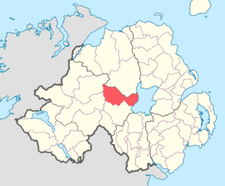
Tiranny is a barony in County Armagh, Northern Ireland. It lies on the western boundary of the county, bordering County Tyrone to its west and County Monaghan in the Republic of Ireland to its south. It is bordered by three other baronies in Northern Ireland: Dungannon Lower and Dungannon Upper to the north-west; and Armagh to the east. It also borders two baronies in the Republic of Ireland; Cremorne to the south and Trough to the west.
McCaul, also spelt MacCawell is an Irish surname, derived from the Gaelic Mac Cathmhaoil, meaning the "son of Cathmhaol", descendant of being implied. The name Cathmhaoil itself is derived from cath mhaol meaning "battle chief". The Mac Cathmhaoil were the leading family of Cenél Fearadhaigh, of the Uí Néill, and were based around Clogher in modern-day County Tyrone, Northern Ireland. They were one of the seven powerful septs that supported the O'Neills. Mac Cathmhaoil is now rare in Ulster as it has been Anglicised under various different forms such as, Campbell, McCawl, Caulfield, McCall, Alwell, Callwell, McCowell, Cowell, McCuill, Howell, MacHall, and McQuade.
The Bhotha Mhuintir Uí Fhialáin were an Irish tribe that lived in the area now known as Boho in County Fermanagh, Northern Ireland.

Coleraine is a barony in County Londonderry, Northern Ireland. It connects to the north-Londonderry coastline, and is bordered by five other baronies: Keenaght to the west; Loughinsholin to the south; North East Liberties of Coleraine, Dunluce Upper, and the Kilconway to the east. Before its creation it was once a territory known as "Firnacreeve".
Loughinsholin is a barony in County Londonderry, Northern Ireland. Its southeast borders the northwest shore of Lough Neagh, and itself is bordered by seven other baronies: Dungannon Upper to the south; Strabane Upper to the west; Keenaght and Coleraine to the north; Kilconway, Toome Upper, and Toome Lower to the east. It was formed largely on the extent of the northern part of the medieval Irish túath of Uí Tuirtri.
Tirkeeran is a barony in County Londonderry, Northern Ireland. It connects to the north-Londonderry coastline, and is bordered by four other baronies: Keenaght to the east; Strabane Lower to the south-east; North West Liberties of Londonderry to the west; and Strabane Upper to the south.

Knockninny is a barony in County Fermanagh, Northern Ireland. To its east lies Upper Lough Erne, and it is bordered by four other baronies in Northern Ireland: Clanawley to the north-west; Tirkennedy to the north; Magherastephana to the north-east; and Coole to the east. It also borders two baronies in the Republic of Ireland: Loughtee Lower to the south; and Tullyhaw to the south-west.
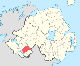
Clankelly is a barony in County Fermanagh, Northern Ireland. It is the only barony in County Fermanagh not connected to Lough Erne. It is bordered by two other baronies in Northern Ireland: Coole to the south-west; and Magherastephana to the north-west. It also borders two baronies in the Republic of Ireland: Monaghan to the north-east; and Dartree to the south-east.
Magherastephana is a barony in County Fermanagh, Northern Ireland. To its south-west lies Upper Lough Erne, and it is bordered by five other baronies: Tirkennedy to the west; Knockninny to the south-west; and Coole to the south; Clankelly to the south-east; and Clogher to the north-west.

Tirkennedy is a barony in County Fermanagh, Northern Ireland. To its west lies Lower Lough Erne and south Upper Lough Erne, and it is bordered by seven other baronies: Clanawley and Magheraboy to the west; Lurg and Omagh East to the north; Clogher to the east; Magherastephana and Knockninny to the south.

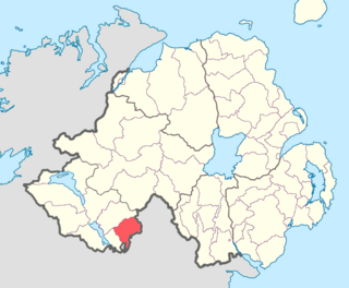
Magheraboy is a barony in County Fermanagh, Northern Ireland. To its east lies Lower Lough Erne, and it is bordered by three other baronies in Northern Ireland: Lurg to the north; Tirkennedy to the east; and Clanawley to the south It also borders two baronies in the Republic of Ireland: Tirhugh to the north; and Rosclogher to the south. The westernmost point of Magheraboy is also the westernmost point of Northern Ireland..

Lurg is a barony situated in the north of County Fermanagh, Northern Ireland. To its south lies Lower Lough Erne, and it is bordered by four other baronies in Northern Ireland: Magheraboy to the south; Tirkennedy to the south-east; Omagh West to the north; and Omagh East to the east. It also borders to the west the barony of Tirhugh in the Republic of Ireland.

Omagh East is a barony in County Tyrone, Northern Ireland. It is bordered by nine other baronies: Omagh West and Lurg to the west; Strabane Lower and Strabane Upper to the north; Dungannon Middle and Dungannon Upper to the east; Clogher and Tirkennedy to the south; and Dungannon Lower to the south-east.

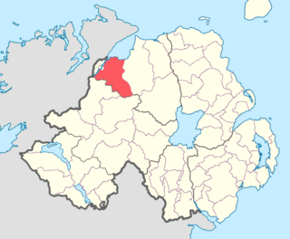
Strabane Upper is a barony in County Tyrone, Northern Ireland. It is bordered by six other baronies: Tirkeeran and Keenaght to the north; Loughinsholin and Dungannon Upper to the east; Omagh East to the south; and Strabane Lower to the west.

Dungannon Lower is a historic barony in County Tyrone, Northern Ireland. It was created in 1851 with the splitting of the barony of Dungannon. It is bordered by four other baronies in Northern Ireland: Dungannon Middle to the north; Tiranny to the south-east; Clogher to the west; and Omagh East to the north-west. It is also bordered in the south-west by the barony of Trough in the Republic of Ireland.
Dungannon Upper is a barony in County Tyrone, Northern Ireland. It was created in 1851 with the splitting of the barony of Dungannon. Lough Neagh runs along its eastern boundary, and it is bordered by four other baronies: Dungannon Middle to the south; Loughinsholin to the north; Strabane Upper to the north-west; and Omagh East to the south-west.

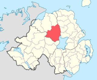
Dungannon Middle is a barony in County Tyrone, Northern Ireland. It was created in 1851 with the splitting of the barony of Dungannon. It is bordered by Lough Neagh to the east and six other baronies: Dungannon Upper to the north; Oneilland West to the south-east; Armagh and Tiranny to the south; Dungannon Lower to the south-west; and Omagh East to the west.

Oneilland West is a barony in County Armagh, Northern Ireland. It is also called Clancann, after the Mac Cana clan. It lies in the north of the county on the south-western shore of Lough Neagh and the border of County Tyrone. Oneilland West is bordered by five other baronies: Armagh to the west; Dungannon Middle to the north-west; Oneilland East to the north-east; Orior Lower to the south-east; and Kinelarty to the south.
The Cenél nEógain or Kinel-Owen are a branch of the Northern Uí Néill, who claim descent from Eógan mac Néill, son of Niall of the Nine Hostages. Originally their power-base was in Inishowen, with their capital at Ailech, in modern-day County Donegal in what is now the west of Ulster. Under pressure from the Cenél Conaill, they gradually spread their influence eastwards into modern counties Tyrone and Londonderry, pushing aside the Cruithin east of the River Bann, and encroaching on the Airgiallan tribes west of Lough Neagh. By the 11th century their power-base had moved from Ailech to Tullyhogue outside Cookstown, County Tyrone. By the 12th century the Cenél Conaill conquered Inishowen; however, it mattered little to the Cenél nEóghain as they had established a powerful over-kingdom in the east that had become known as Tír Eoghain, or the "Land of Owen", preserved in the modern-day name of County Tyrone.
