
County Tyrone is one of the six counties of Northern Ireland, one of the nine counties of Ulster and one of the thirty-two traditional counties of Ireland. It is no longer used as an administrative division for local government but retains a strong identity in popular culture.
South Tyrone was a UK Parliament constituency in Ireland which returned one Member of Parliament from 1885 to 1922, using the first past the post electoral system.

Brackaville or Bracaville is a village and townland near Coalisland in County Tyrone, Northern Ireland. It is situated in the historic barony of Dungannon Middle and the civil parish of Donaghenry and covers an area of 235 acres on the western side of Lough Neagh.
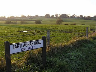
Drumkee is a townland in the southeast of County Tyrone, Northern Ireland. It is directly south of the area presently known as Coalisland and east, and slightly north, of Dungannon. It is situated in the historic barony of Dungannon Middle and the civil parish of Killyman and covers an area of 285 acres. The barony's tax records dated 1666 list two families living in Drumkee.

Killyman is a small village and a civil parish in Northern Ireland, situated on the eastern boundary of County Tyrone and extending into County Armagh. The majority of townlands are in the historic barony of Dungannon Middle in County Tyrone, the rest being in the barony of Oneilland West in County Armagh.

Carnteel ) is a hamlet, townland and civil parish, about 2 miles northeast of Aughnacloy in County Tyrone, Northern Ireland. It is situated in the historic barony of Dungannon Lower.
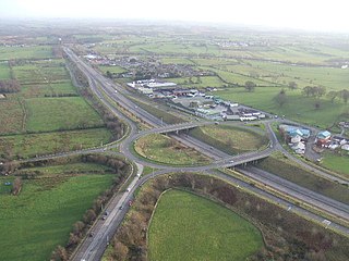
Tamnamore is a small village in County Tyrone, Northern Ireland, beside exit 14 on the M1 motorway, 7 km east of Dungannon. It lies within the townland of Tamlaghtmore in the civil parish of Killyman, the historic barony of Dungannon Middle, and is situated in Dungannon and South Tyrone Borough Council.

Tiranny is a barony in County Armagh, Northern Ireland. It lies on the western boundary of the county, bordering County Tyrone to its west and County Monaghan in the Republic of Ireland to its south. It is bordered by three other baronies in Northern Ireland: Dungannon Lower and Dungannon Upper to the north-west; and Armagh to the east. It also borders two baronies in the Republic of Ireland; Cremorne to the south and Trough to the west.
Loughinsholin is a barony in County Londonderry, Northern Ireland. Its southeast borders the northwest shore of Lough Neagh, and itself is bordered by seven other baronies: Dungannon Upper to the south; Strabane Upper to the west; Keenaght and Coleraine to the north; Kilconway, Toome Upper, and Toome Lower to the east. It was formed largely on the extent of the northern part of the medieval Irish túath of Uí Tuirtri.
Tirkeeran is a barony in County Londonderry, Northern Ireland. It connects to the north-Londonderry coastline, and is bordered by four other baronies: Keenaght to the east; Strabane Lower to the south-east; North West Liberties of Londonderry to the west; Strabane Upper to the south.

The North West Liberties of Londonderry is a barony in County Londonderry, Northern Ireland. It is bordered by two other baronies in Northern Ireland: Tirkeeran to the east, across Lough Foyle, and Strabane Lower to the south. It also borders two baronies in County Donegal in the Republic of Ireland. It borders Raphoe North, to the south-west; and Inishowen West to the north.
Clogher is a barony in County Tyrone, Northern Ireland. It is bordered by four other baronies in Northern Ireland: Omagh East to the north; Dungannon Lower to the east; Magherastephana to the south; and Tirkennedy to the south-west. It also borders two baronies in the Republic of Ireland: Trough and Monaghan both to the south-east.

Omagh East is a barony in County Tyrone, Northern Ireland. It is bordered by nine other baronies: Omagh West and Lurg to the west; Strabane Lower and Strabane Upper to the north; Dungannon Middle and Dungannon Upper to the east; Clogher and Tirkennedy to the south; and Dungannon Lower to the south-east.

Omagh West is a barony in County Tyrone, Northern Ireland. It is bordered by three other baronies in Northern Ireland: Strabane Lower to the north-east; Omagh East to the east; and Lurg to the south. It also borders two baronies in County Donegal in the Republic of Ireland: Tirhugh to the south-west; and Raphoe South to the north-west.

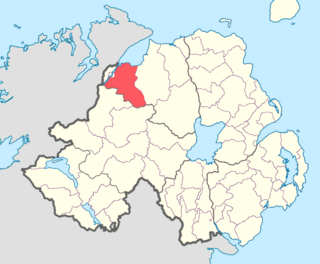
Strabane Lower is a barony in County Tyrone, Northern Ireland. It is bordered by five other baronies in Northern Ireland: North West Liberties of Derry to the north; Tirkeeran to the north-east; Strabane Upper to the east; Omagh East to the south; and Omagh West to the south-west. It also borders two baronies in County Donegal in the Republic of Ireland: Raphoe North and Raphoe South to the west.

Strabane Upper is a barony in County Tyrone, Northern Ireland. It is bordered by six other baronies: Tirkeeran and Keenaght to the north; Loughinsholin and Dungannon Upper to the east; Omagh East to the south; and Strabane Lower to the west.
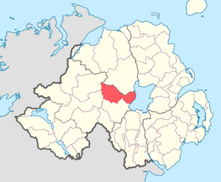
Dungannon Upper is a barony in County Tyrone, Northern Ireland. It was created in 1851 with the splitting of the barony of Dungannon. Lough Neagh runs along its eastern boundary, and it is bordered by four other baronies: Dungannon Middle to the south; Loughinsholin to the north; Strabane Upper to the north-west; and Omagh East to the south-west.

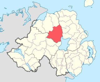
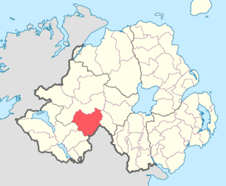
Dungannon Middle is a barony in County Tyrone, Northern Ireland. It was created in 1851 with the splitting of the barony of Dungannon. It is bordered by Lough Neagh to the east and six other baronies: Dungannon Upper to the north; Oneilland West to the south-east; Armagh and Tiranny to the south; Dungannon Lower to the south-west; and Omagh East to the west.

Armagh is a barony in County Armagh, Northern Ireland. It lies in the west of the county, bordering County Tyrone with its north-western boundary, and bordering the Republic of Ireland with its southern boundary. It is bordered by five other baronies in Northern Ireland: Tiranny to the west, Dungannon Middle to the north-west, Oneilland West to the north-east, Fews Lower to the east, and Fews Upper to the south-east. It also borders to the south the barony of Cremorne in the Republic of Ireland.

Oneilland West is a barony in County Armagh, Northern Ireland. It is also called Clancann, after the Mac Cana clan. It lies in the north of the county on the south-western shore of Lough Neagh and the border of County Tyrone. Oneilland West is bordered by five other baronies: Armagh to the west; Dungannon Middle to the north-west; Oneilland East to the north-east; Orior Lower to the south-east; and Kinelarty to the south.
