Related Research Articles
McDowell County is a county in the U.S. state of West Virginia. As of the 2020 census, the population was 19,111. Its county seat is Welch. McDowell County is the southernmost county in the state. It was created in 1858 by the Virginia General Assembly and named for Virginia Governor James McDowell. It became a part of West Virginia in 1863, when several Union-affiliated counties seceded from the state of Virginia during the American Civil War. McDowell County is located in the Cumberland Mountains, part of the Appalachia region.
Gary is a city located along the Tug Fork River in McDowell County, West Virginia, United States. According to the 2020 census, the city had a population of 762. It was named for Elbert Henry Gary, one of the founders of U.S. Steel. The former coal towns of Elbert, Filbert, Thorpe, and Wilcoe became part of Gary at the time of its incorporation in 1971.
Midlothian is an unincorporated area and Census-designated place in Chesterfield County, Virginia, U.S. Settled as a coal town, Midlothian village experienced suburbanization effects and is now part of the western suburbs of Richmond, Virginia south of the James River in the Greater Richmond Region. Because of its unincorporated status, Midlothian has no formal government, and the name is used to represent the original small Village of Midlothian and a vast expanse of Chesterfield County in the northwest portion of Southside Richmond served by the Midlothian post office.
Caretta is an unincorporated community located in McDowell County, West Virginia, United States. Caretta was named for the transposed syllables in the name of Mrs. Etta Carter, the wife of George Lafayette Carter. It is the only place in the United States with this name.

The Battle of Blair Mountain was the largest labor uprising in United States history and the largest armed uprising since the American Civil War. The conflict occurred in Logan County, West Virginia, as part of the Coal Wars, a series of early-20th-century labor disputes in Appalachia. Up to 100 people were killed, and many more arrested.

Jenkinjones is an unincorporated community and coal town in McDowell County, West Virginia, United States. It lies on the western flanks of Stone Ridge near the border with Tazewell County, Virginia.

The New River Coalfield is located in northeastern Raleigh County and southern Fayette County, West Virginia. Commercial mining of coal began in the 1870s and thrived into the 20th century. The coal in this field is a low volatile coal, known as "smokeless" coals. The seams of coal that have been mined include Sewell, Fire Creek, and Beckley. This is very high quality bituminous coal rated at approximately 15,000 BTU (16,000 kJ). The New River coalfield is named after the north flowing New River. Over 60 coal towns were once located there, supported by independent commercial districts at Beckley, Oak Hill, Mount Hope, and Fayetteville. By the 21st century many coal camps had partially or completely returned to nature. These company towns were located along Dunloup (Loup) Creek, Laurel Creek, White Oak Creek, lower Piney Creek, and, of course, the New River. The mainline of the Chesapeake and Ohio Railway ran right through the center of this coalfield, with spurs branching off in many directions, and rail yards were maintained at Quinnimont, Raleigh, and Thurmond, WV. The Virginian Railway's main line also passed through the western side of the field as well. Companies such as the New River Company, New River & Pocahontas Consolidated Coal Co., and Mary Frances Coal Co. were the largest operators in the New River Coalfield, but there were many smaller ones as well. These companies recruited native born whites, immigrants from Southern and Eastern Europe, and African-Americans from the South to work in their coal mines and railroads. The mines began to close down after World War II and today there are very few active coal mines in the field. The New River Gorge is now the domain of the National Park Service as the New River Gorge National Park and Preserve, and they have done what their budget allows to preserve the coal heritage of the area.

Pocahontas Coalfield, which is also known as the Flat Top-Pocahontas Coalfield, is located in Mercer County/McDowell County, West Virginia and Tazewell County, Virginia. The earliest mining of coal in the coalfield was in Pocahontas, Virginia in 1883 at Pocahontas Mine No. 1, now on the National Register of Historic Places.
Landgraff is an unincorporated community in McDowell County, West Virginia, United States. It is located along U.S. Route 52 and Elkhorn Creek, approximately 6.4 miles (10.3 km) east of the county seat of Welch.
The Logan Coalfield is a coalfield located in Logan County and Wyoming County of southern West Virginia, in the Appalachia region of the eastern United States.

Kay Moor, also known as Kaymoor, is the site of an abandoned coal mine, coal-processing plant, and coal town near Fayetteville, West Virginia. The town site is located in the New River Gorge at Kaymoor Bottom (38°03′00″N81°03′17″W). It is linked to the mine portal 560 feet (170 m) above on Sewell Bench (38°02′52″N81°03′58″W) in the wall of the Gorge by conveyors.
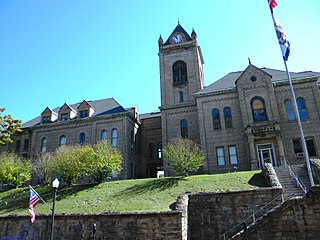
The McDowell County Courthouse is a historic courthouse in Welch, West Virginia. It was placed on the National Register of Historic Places on August 29, 1979.

The World War Memorial in Kimball, West Virginia commemorates African Americans who served in World War I. The building sits on a hill in Kimball, a town in McDowell County, West Virginia. Constructed in 1928, the site was the first memorial of African-American veterans in the United States.

The Nuttallburg Coal Mining Complex and Town Historic District is located near Winona, West Virginia in New River Gorge National Park and Preserve. The townsite is almost directly across from the Kay Moor mine and townsite, now abandoned. Like Kay Moor, the town is built around the railroad line at the bottom of the gorge, with an array of coke ovens and mining structures, as well as a bridge across the New River to South Nuttall.
The National Coal Heritage Area (NCHA) is a federally designated National Heritage Area encompassing a region of thirteen counties in West Virginia that were the source of "smokeless" bituminous coal through much of the 20th century. The National Heritage Area recognizes the area's cultural and historic qualities and serves to promote tourism, historic preservation and economic development in the region. The idea of the NCHA was first proposed in the early 1990s by Congressman Nick Rahall, and was established on November 12, 1996 by the 1996 Omnibus Parks and Public Lands Management Act. The designated area includes Boone, Cabell, Fayette, Logan, Lincoln, McDowell, Mercer, Mingo, Raleigh, Summers, and Wayne counties.
The coal towns, or "coal camps" of Fayette County, West Virginia were situated to exploit the area's rich coal seams. Many of these towns were located in deep ravines that afforded direct access to the coal through the hillsides, allowing mined coal to be dropped or conveyed downhill to railway lines at the valley floor. Many of these encampments were set up as company towns, and when their mines closed, the towns vanished. A few, like Thurmond, West Virginia, have survived in a reduced state. Fayette County covers portions of three coalfields: the New River Coalfield, the Kanawha Coalfield and the Greenbrier Coalfield. Below is a partial list of known coal towns within the three coalfields: the New River Coalfield, the Kanawha Coalfield and the Greenbrier Coalfield. More may be found here
The coal mining communities, or coal towns of Raleigh County, West Virginia were situated to exploit the area's rich coal seams. Many of these towns were located in deep ravines that afforded direct access to the coal through the hillsides, allowing mined coal to be dropped or conveyed downhill to railway lines at the valley floor. Many of these encampments were set up as coal towns, and when their mines closed, the towns vanished. Raleigh County covers portions of three coalfields: the New River Coalfield, the Winding Gulf Coalfield and the Coal River Coalfield. Below is partial listing of known coal towns. Further listings are available here
The coal towns, or "coal camps" of Mingo County, West Virginia were situated to exploit the area's rich coal seams. Many of these towns were located in deep ravines that afforded direct access to the coal through the hillsides, allowing mined coal to be dropped or conveyed downhill to railway lines at the valley floor. Many of these encampments were set up as coal towns, and when their mines closed, the towns vanished. Mingo County covers the Williamson Coalfield and a small portion of the Logan Coalfield. Below is partial listing of known coal towns within the Williamson Coalfield and a small portion of the Logan Coalfield. Further listings are available here
The Richmond Coalfield was the first coalfield to be mined commercially in the United States of America. The coalfield is located several miles west of the city of Richmond, Virginia. Its bituminous coal seams are a part of the Richmond Basin, dating to the Late Triassic.

Pocahontas Fuel Company operated mines in the state of Virginia in Boissevain and Amonate, and in West Virginia at Jenkinjones, Bishop, and Itmann. Pocahontas Fuel Company founded the Pocahontas Consolidated Collieries Company in 1907. In 1956 Pocahontas was acquired by the Consolidation Coal Company. Consolidation Coal Company became Consol Energy in 1991. Consol Energy mines coal at Amonate. Pocahontas Fuel Company used the Norfolk & Western Railway bring the coal to ports for shipment.
References
- ↑ Sharon A. Brown (July 13, 1990). "National Register of Historic Places Nomination: Kay Moor" (PDF). National Park Service.
{{cite journal}}: Cite journal requires|journal=(help) - 1 2 "McDowell County, West Virginia" (PDF). National Coal Heritage Area. Coal Heritage Highway Authority. Retrieved March 14, 2012.