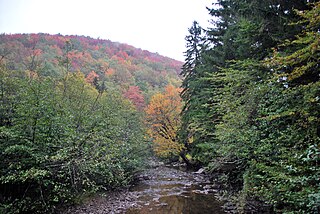
The Black Fork is a principal tributary of the Cheat River in the Allegheny Mountains of eastern West Virginia, USA. It is a short stream, about four miles (6 km) in length, formed by the confluence of two other streams not far above its mouth. It was traditionally considered one of the five Forks of Cheat.

The Blackwater River is a 34.3-mile-long (55.2 km) river in the Allegheny Mountains of eastern West Virginia, USA. Via the Black Fork, it is a principal tributary of the Cheat River. Via the Cheat, the Monongahela and the Ohio rivers, it is part of the watershed of the Mississippi River and drains an area of 142 square miles (370 km2). It is a true blackwater stream, owing to spruce and hemlock trees in its watershed, the tannins of which impart a tea or amber color to its water.

The Dry Fork is a 39.1-mile-long (62.9 km) tributary of the Black Fork of the Cheat River in the Allegheny Mountains of eastern West Virginia, USA. Via the Black Fork, the Cheat, and the Monongahela and Ohio rivers, it is part of the watershed of the Mississippi River. The Dry Fork flows for much of its length in the Monongahela National Forest and drains mostly rural and forested areas. It was traditionally considered one of the five Forks of Cheat.
Apple Grove is an unincorporated community located in McDowell County, West Virginia, United States. Apple Grove is located along West Virginia Route 80 on the Dry Fork, south of Iaeger.
Atwell is an unincorporated community located in McDowell County, West Virginia, United States. Atwell lies along the Norfolk and Western Railroad on the Dry Fork.
Avondale is an unincorporated community located in McDowell County, West Virginia, United States. Avondale lies along the Norfolk and Western Railroad on the Dry Fork. According to the Geographic Names Information System, the community has also been known as Ritter having been named after William McLellan Ritter, founder of the W.M. Ritter company.
Bartley is a census-designated place (CDP) located in McDowell County, West Virginia, United States. It lies along the Norfolk and Western Railroad on the Dry Fork. As of the 2010 census, its population was 224. According to the Geographic Names Information System, Bartley has also been known as Bartlett and Peeryville.
Beartown is an unincorporated community located in McDowell County, West Virginia, United States. Beartown lies along the Norfolk and Western Railroad on Dry Fork.
Black Wolf is an unincorporated community located in McDowell County, West Virginia, United States. Black Wolf lies along the Norfolk and Western Railroad on the Tug Fork River.
Carlos is an unincorporated community located in McDowell County, West Virginia, United States. Carlos lies along the Norfolk and Western Railroad on the Dry Fork.
English is an unincorporated community in McDowell County, West Virginia, United States. Its post office was closed on November 9, 2002. It was the seat of its county until 1892, when it was moved to Welch. The town is on the Norfolk Southern Railway network and also the Tug Fork river.

The Dry Fork is a 47.7-mile-long (76.8 km) tributary of the Tug Fork, belonging to the Ohio River watershed. The river is located in McDowell County, West Virginia, and Tazewell County, Virginia, in the United States. The mouth of the Dry Fork into the Tug Fork is located at Iaeger.

Glady Fork is a 31.9-mile-long (51.3 km) river in the Allegheny Mountains of eastern West Virginia, USA. It is considered one of the five principal headwaters tributaries of the Cheat River — known as the Forks of Cheat.

Laurel Fork is a 37.8-mile-long (60.8 km) river in eastern West Virginia, USA. It is a tributary of the Dry Fork; via the Dry Fork, the Black Fork, and the Cheat, Monongahela and Ohio rivers, it is part of the watershed of the Mississippi River, draining an area of 60 square miles (160 km2) in the Allegheny Mountains. With the Dry Fork, the Glady Fork, the Shavers Fork and the Blackwater River, it is considered to be one of the five principal headwaters tributaries of the Cheat River.
Dry Fork is an unincorporated community in Randolph and Tucker counties, West Virginia, United States. It is located along West Virginia Route 32, 3.5 miles (5.6 km) north-northeast of Harman. Dry Fork has a post office with ZIP code 26263.
Litwar is an unincorporated community in McDowell County, West Virginia, United States. Litwar is located on the Tug Fork, 2 miles (3.2 km) west-northwest of Iaeger.
Union City is an unincorporated community in McDowell County, West Virginia, United States. Union City is located on the Dry Fork and West Virginia Route 80, 2.5 miles (4.0 km) south-southeast of Iaeger.
Garland is an unincorporated community in McDowell County, West Virginia, United States. Garland is located near West Virginia Route 80, 3.5 miles (5.6 km) north-northeast of Bradshaw.
Krollitz is an unincorporated community in McDowell County, West Virginia, United States. Krollitz is 2.8 miles (4.5 km) west of Iaeger.
Wyoming City is an unincorporated community in McDowell County, West Virginia, United States. Wyoming City is 7 miles (11 km) west-northwest of Iaeger.


