The Ohio River is a 981-mile (1,579 km) long river in the midwestern United States that flows southwesterly from western Pennsylvania south of Lake Erie to its mouth on the Mississippi River at the southern tip of Illinois. It is the second largest river by discharge volume in the United States and the largest tributary by volume of the north-south flowing Mississippi River that divides the eastern from western United States. The river flows through or along the border of six states, and its drainage basin includes parts of 15 states. Through its largest tributary, the Tennessee River, the basin includes several states of the southeastern U.S. It is the source of drinking water for three million people.
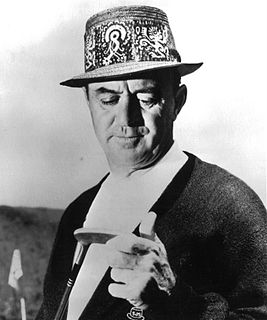
Samuel Jackson Snead was an American professional golfer who was one of the top players in the world for the better part of four decades and one of the greatest players of all time. Snead won a record 82 PGA Tour events, including seven majors. He never won the U.S. Open, though he was runner-up four times.
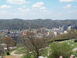
Charleston is the most populous city in, and the capital of, the U.S. state of West Virginia. Located at the confluence of the Elk and Kanawha rivers, the population during the 2017 Census Estimate was 47,929. The Charleston metropolitan area as a whole had 214,406 residents. Charleston is the center of government, commerce, and industry for Kanawha County, of which it is the county seat.

Fond du Lac County is a county in the U.S. state of Wisconsin. As of the 2010 census, the population was 101,633. Its county seat is Fond du Lac. The county was created in the Wisconsin Territory in 1836 and later organized in 1844. Fond du Lac is French for "bottom of the lake", so given because of the county's location at the southern shore of Lake Winnebago.

The Shenandoah Valley is a geographic valley and cultural region of western Virginia and the Eastern Panhandle of West Virginia in the United States. The valley is bounded to the east by the Blue Ridge Mountains, to the west by the eastern front of the Ridge-and-Valley Appalachians, to the north by the Potomac River and to the south by the James River. The cultural region covers a larger area that includes all of the valley plus the Virginia highlands to the west, and the Roanoke Valley to the south. It is physiographically located within the Ridge and Valley province and is a portion of the Great Appalachian Valley.

West Virginia University (WVU) is a public, land-grant, space-grant, research-intensive university in Morgantown, West Virginia, United States. Its other campuses include the West Virginia University Institute of Technology in Beckley and Potomac State College of West Virginia University in Keyser; and a second clinical campus for the University's medical and dental schools at Charleston Area Medical Center in Charleston. WVU Extension Service provides outreach with offices in all of West Virginia's 55 counties. Since 2001, WVU has been governed by the West Virginia University Board of Governors.

These are tables of congressional delegations from West Virginia to the United States House of Representatives and the United States Senate.

Marystown is a town in the province of Newfoundland and Labrador, Canada, with a population of 5,506 as of 2011. Situated 306 km from the province's capital, St. John's, it is on the Burin Peninsula. Until the early 1990s, its economy was largely based on shipbuilding, and it is due in part to this that the town experienced a population increase of 295% in just over a decade. The town was also dependent on the fish plant for employment.

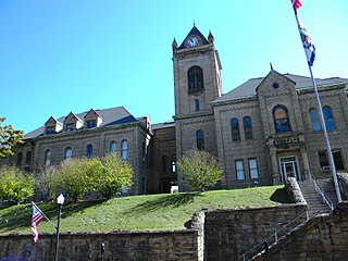
This is a list of properties and historic districts in West Virginia that are listed on the National Register of Historic Places. There are listings in every one of West Virginia's 55 counties.
State Trunk Highway 149 was a state highway in the U.S. state of Wisconsin. It ran through Manitowoc, Calumet, and Fond du Lac counties.

The Huntington–Ashland metropolitan area is the largest metropolitan statistical area in West Virginia and includes seven counties across three states: West Virginia, Kentucky, and Ohio. New definitions from February 28, 2013 placed the population at 361,580. The MSA is nestled along the banks of the Ohio River within the Appalachian Plateau region. The area is referred to locally as the "Tri-State area". In addition, the three largest cities are referred to as the River Cities.

Johnsburg, Wisconsin is an unincorporated community in the Town of Calumet in Fond du Lac County, Wisconsin. The community is located on County Roads Q and W, approximately 3.3 miles (5.3 km) east of Lake Winnebago, 2.75 miles (4.43 km) southeast of Pipe and 1.4 miles (2.3 km) northwest of Malone. Johnsburg is part of the Holyland region in northeastern Fond du Lac county.
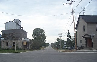
Marytown, Wisconsin is an unincorporated community in Fond du Lac County, Wisconsin, in the town of Calumet. Marytown is located at the intersection of Fond du Lac County highways G and HH. Wisconsin Highway 149 ran north to south through the community before it was decommissioned in 2006.
A war hawk is a person who actively supports a war.

St. Anna is an unincorporated community in Calumet and Sheboygan Counties in the U.S. state of Wisconsin. It lies in the towns of Russell and New Holstein.

St. Peter, Wisconsin is an unincorporated census-designated place in the Town of Taycheedah in Fond du Lac County, Wisconsin. It is located approximately 2 miles (3.2 km) northeast of Peebles and 1 mile (1.6 km) south of Silica. It was located on Wisconsin Highway 149 before the highway was decommissioned and turned over to county control as County Highway WH. As of the 2010 census, its population is 1,489.