Coburn, Pennsylvania

Last updated
Coburn, Pennsylvania
Map of Coburn, Centre County, Pennsylvania Highlighted.png
Location of Coburn in Centre County
Map of Pennsylvania highlighting Centre County.svg
Location of Centre County in Pennsylvania
Coordinates: 40°51′46″N77°27′44″W / 40.86278°N 77.46222°W / 40.86278; -77.46222 Coordinates: 40°51′46″N77°27′44″W / 40.86278°N 77.46222°W / 40.86278; -77.46222
Country United States
State Pennsylvania
County Centre
Township Penn
Area
[1]
  Total0.35 sq mi (0.90 km2)
  Land0.35 sq mi (0.90 km2)
  Water0.00 sq mi (0.00 km2)
Elevation
1,030 ft (310 m)
Population
 (2020) [2]
  Total210
  Density601.72/sq mi (232.65/km2)
Time zone UTC-5 (Eastern (EST))
  Summer (DST) UTC-4 (EDT)
ZIP code
16832
FIPS code 42-14760
GNIS feature ID1172103

Coburn is a census-designated place (CDP) in Centre County, Pennsylvania, United States. It is part of the State College, Pennsylvania Metropolitan Statistical Area. The population was 236 at the 2010 census. [3]

Contents

Geography

Coburn is located in eastern Centre County, in the eastern part of Penn Township. The town is sited at the junction of Pine Creek and Penns Creek, where Penns Creek turns south, leaving the Penns Valley, and begins slicing through a series of Appalachian Mountain ridges, starting with First Mountain at the southern edge of Coburn. The borough of Millheim is 2.5 miles (4.0 km) north of Coburn.

According to the United States Census Bureau, the CDP has a total area of 0.4 square miles (1.0 km2), all land. [3]

History

Growth of the town was aided by the Lewisburg and Tyrone Railroad. The section of track east of Coburn was abandoned in 1970; the section to the west in 1972.

Demographics

Historical population
CensusPop.
2020 210
U.S. Decennial Census [4] [2]

As of the census [5] of 2000, there were 145 people, 57 households, and 40 families living in the CDP. The population density was 665.8 people per square mile (254.5/km2). There were 62 housing units at an average density of 284.7/sq mi (108.8/km2). The racial makeup of the CDP was 97.93% White, 0.69% Asian, and 1.38% from two or more races. Hispanic or Latino of any race were 0.69% of the population.

There were 57 households, out of which 28.1% had children under the age of 18 living with them, 57.9% were married couples living together, 8.8% had a female householder with no husband present, and 28.1% were non-families. 19.3% of all households were made up of individuals, and 8.8% had someone living alone who was 65 years of age or older. The average household size was 2.54 and the average family size was 2.90.

In the CDP, the population was spread out, with 22.1% under the age of 18, 7.6% from 18 to 24, 24.1% from 25 to 44, 31.7% from 45 to 64, and 14.5% who were 65 years of age or older. The median age was 42 years. For every 100 females, there were 110.1 males. For every 100 females age 18 and over, there were 101.8 males.

The median income for a household in the CDP was $47,083, and the median income for a family was $37,500. Males had a median income of $29,167 versus $33,125 for females. The per capita income for the CDP was $16,510. There were 7.9% of families and 13.6% of the population living below the poverty line, including 30.6% of under eighteens and none of those over 64.

Related Research Articles

<span class="mw-page-title-main">Brickerville, Pennsylvania</span> Census-designated place in Pennsylvania, United States

Brickerville is an unincorporated community and census-designated place (CDP) in Elizabeth Township, Lancaster County, Pennsylvania, United States, with a ZIP code of 17543. The population was 1,309 at the 2010 census.

<span class="mw-page-title-main">Oak Hills, Pennsylvania</span> Census-designated place in Pennsylvania, United States

Oak Hills is a census-designated place (CDP) in Butler County, Pennsylvania, United States. The population was 2,333 at the 2010 census.

<span class="mw-page-title-main">Blanchard, Centre County, Pennsylvania</span> Census-designated place in Pennsylvania, United States

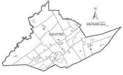
Blanchard is a census-designated place (CDP) in Centre County, Pennsylvania, United States. It is part of the State College, Pennsylvania Metropolitan Statistical Area. The population was 740 at the 2010 census.

<span class="mw-page-title-main">Clarence, Pennsylvania</span> Census-designated place in Pennsylvania, United States

Clarence is a census-designated place (CDP) in Centre County, Pennsylvania, United States. It is part of the State College, Pennsylvania Metropolitan Statistical Area. The population was 626 at the 2010 census.

<span class="mw-page-title-main">Monument, Pennsylvania</span> Census designated place in Pennsylvania, United States

Monument is an unincorporated community and census-designated place in Centre County, Pennsylvania, United States. It is part of the State College, Pennsylvania Metropolitan Statistical Area. The population was 150 at the 2010 census.

<span class="mw-page-title-main">Spring Mills, Pennsylvania</span> Census designated place in Pennsylvania, United States

Spring Mills is an unincorporated community and census-designated place (CDP) in Centre County, Pennsylvania, United States. It is part of the State College, Pennsylvania Metropolitan Statistical Area. The population was 268 at the 2010 census.

<span class="mw-page-title-main">Woodward, Pennsylvania</span> Census-designated place in Pennsylvania, United States

Woodward is an unincorporated community and census-designated place in Centre County, Pennsylvania, United States. It is part of the State College, Pennsylvania, Metropolitan Statistical Area. The population was 110 at the 2010 census.

<span class="mw-page-title-main">Castanea, Pennsylvania</span> Census-designated place in Pennsylvania, United States

Castanea is a census-designated place (CDP) in Castanea Township, Clinton County, Pennsylvania, United States. The population was 1,125 at the 2010 census.

<span class="mw-page-title-main">Eyers Grove, Pennsylvania</span> Census-designated place in Pennsylvania, United States

Eyers Grove is a census-designated place in Columbia County, Pennsylvania, United States. The population was 105 at the 2010 census. It is part of the Bloomsburg–Berwick Micropolitan Statistical Area.

<span class="mw-page-title-main">Fernville, Pennsylvania</span> Census-designated place in Pennsylvania, United States

Fernville is a census-designated place (CDP) in Columbia County, Pennsylvania, United States. The population was 556 at the 2010 census. It is part of the Bloomsburg–Berwick Micropolitan Statistical Area.

<span class="mw-page-title-main">Rupert, Pennsylvania</span> Census-designated place in Pennsylvania, United States

Rupert is a census-designated place (CDP) in Columbia County, Pennsylvania, United States. The population was 183 at the 2010 census. It is part of the Bloomsburg–Berwick Micropolitan Statistical Area.

<span class="mw-page-title-main">Lincolnville, Pennsylvania</span> Census-designated place in Pennsylvania, United States

Lincolnville is a census-designated place in Crawford County, Pennsylvania, United States. The population was 96 at the 2010 census.

<span class="mw-page-title-main">Republic, Pennsylvania</span> Census-designated place in Pennsylvania, United States

Republic is an unincorporated community and census-designated place (CDP) in Fayette County, Pennsylvania, United States. The population was 1,096 at the 2010 census, down from 1,396 at the 2000 census. The community is in Redstone Township.

Avon is an unincorporated community and census-designated place (CDP) in Lebanon County, Pennsylvania, United States. The population was 1,667 at the 2010 census, down from 2,856 at the 2000 census.

<span class="mw-page-title-main">Quentin, Pennsylvania</span> Census-designated place in Pennsylvania, United States

Quentin is an unincorporated community and census-designated place (CDP) in Lebanon County, Pennsylvania, United States. It was named after Quentin Roosevelt, youngest son of President Theodore Roosevelt. The population was 594 at the 2010 census, up from 529 at the 2000 census.

<span class="mw-page-title-main">Reedsville, Pennsylvania</span> Census-designated place in Pennsylvania, United States

Reedsville is a census-designated place (CDP) in the Kishacoquillas Valley of Mifflin County, Pennsylvania, United States. The population was 641 at the 2010 census. Reedsville has a high Amish population.

<span class="mw-page-title-main">Kulpsville, Pennsylvania</span> Census-designated place in Pennsylvania, United States

Kulpsville is a census-designated place (CDP) in Montgomery County, Pennsylvania, United States. The population was 8,194 at the 2010 census. It is located in Towamencin Township, which is part of the North Penn Valley region that is centered around the borough of Lansdale. The name is derived from the Kulp family.

<span class="mw-page-title-main">Nuremberg, Pennsylvania</span> Census-designated place in Pennsylvania, United States

Nuremberg is a census-designated place (CDP) in Schuylkill and Luzerne counties, Pennsylvania, United States. The population was 434 at the 2010 census.

<span class="mw-page-title-main">Penns Creek, Pennsylvania</span> CDP in Pennsylvania, United States

Penns Creek is a census-designated place (CDP) in Snyder County, Pennsylvania, United States. Its ZIP code is 17862.

<span class="mw-page-title-main">Pennville, Pennsylvania</span> CDP in Pennsylvania, United States

Pennville is a census-designated place (CDP) in York County, Pennsylvania, United States. The population was 1,947 at the 2010 census.

References

  1. "ArcGIS REST Services Directory". United States Census Bureau. Retrieved October 12, 2022.
  2. 1 2 "Census Population API". United States Census Bureau. Retrieved Oct 12, 2022.
  3. 1 2 "Geographic Identifiers: 2010 Census Summary File 1 (G001): Coburn CDP, Pennsylvania". U.S. Census Bureau, American Factfinder. Archived from the original on April 14, 2015. Retrieved April 14, 2015.
  4. "Census of Population and Housing". Census.gov. Retrieved June 4, 2016.
  5. "U.S. Census website". United States Census Bureau . Retrieved 2008-01-31.