Cogswell, North Dakota

Last updated

Cogswell, North Dakota
Cogswell Community Center - Cogswell, North Dakota 6-11-2009.jpg
Cogswell Community Center
ND Sargent County Cogswell.svg
Location of Cogswell, North Dakota
Coordinates: 46°06′25″N97°47′03″W / 46.10694°N 97.78417°W / 46.10694; -97.78417
CountryUnited States
State North Dakota
County Sargent
Founded1890
Area
[1]
  Total0.33 sq mi (0.85 km2)
  Land0.33 sq mi (0.85 km2)
  Water0.00 sq mi (0.00 km2)
Elevation
[2]
1,303 ft (397 m)
Population
 (2020) [3]
  Total73
  Estimate 
(2022) [4]
71
  Density221.21/sq mi (85.52/km2)
Time zone UTC-6 (Central (CST))
  Summer (DST) UTC-5 (CDT)
ZIP code
58017
Area code 701
FIPS code 38-15100
GNIS feature ID1035973 [2]

Cogswell is a city in Sargent County, North Dakota, United States. The population was 73 at the 2020 census. [3] Cogswell was founded in 1890.

Contents

Geography

According to the United States Census Bureau, the city has a total area of 0.33 square miles (0.85 km2), all land. [5]

Demographics

Historical population
CensusPop.Note
1910 418
1920 4456.5%
1930 426−4.3%
1940 4300.9%
1950 393−8.6%
1960 305−22.4%
1970 203−33.4%
1980 22711.8%
1990 184−18.9%
2000 165−10.3%
2010 99−40.0%
2020 73−26.3%
2022 (est.)71 [4] −2.7%
U.S. Decennial Census [6]
2020 Census [3]

2010 census

As of the census of 2010, there were 99 people, 50 households, and 30 families residing in the city. The population density was 300.0 inhabitants per square mile (115.8/km2). There were 73 housing units at an average density of 221.2 per square mile (85.4/km2). The racial makeup of the city was 94.9% White and 5.1% Native American.

There were 50 households, of which 14.0% had children under the age of 18 living with them, 50.0% were married couples living together, 4.0% had a female householder with no husband present, 6.0% had a male householder with no wife present, and 40.0% were non-families. 38.0% of all households were made up of individuals, and 14% had someone living alone who was 65 years of age or older. The average household size was 1.98 and the average family size was 2.53.

The median age in the city was 52.1 years. 14.1% of residents were under the age of 18; 3.1% were between the ages of 18 and 24; 9% were from 25 to 44; 56.6% were from 45 to 64; and 17.2% were 65 years of age or older. The gender makeup of the city was 57.6% male and 42.4% female.

2000 census

As of the census of 2000, there were 165 people, 68 households, and 49 families residing in the city. The population density was 493.4 inhabitants per square mile (190.5/km2). There were 81 housing units at an average density of 242.2 per square mile (93.5/km2). The racial makeup of the city was 99.39% White, and 0.61% from two or more races. Hispanic or Latino of any race were 1.82% of the population.

There were 68 households, out of which 33.8% had children under the age of 18 living with them, 63.2% were married couples living together, 1.5% had a female householder with no husband present, and 27.9% were non-families. 27.9% of all households were made up of individuals, and 17.6% had someone living alone who was 65 years of age or older. The average household size was 2.43 and the average family size was 2.92.

In the city, the population was spread out, with 26.1% under the age of 18, 6.7% from 18 to 24, 29.1% from 25 to 44, 23.0% from 45 to 64, and 15.2% who were 65 years of age or older. The median age was 39 years. For every 100 females, there were 103.7 males. For every 100 females age 18 and over, there were 106.8 males.

The median income for a household in the city was $35,000, and the median income for a family was $45,208. Males had a median income of $31,250 versus $19,375 for females. The per capita income for the city was $14,086. About 1.8% of families and 2.5% of the population were below the poverty line, including none of those under the age of eighteen and 7.1% of those 65 or over.

Related Research Articles

<span class="mw-page-title-main">Eagle, Idaho</span> City in Idaho, United States

Eagle is a city in Ada County, Idaho, United States, 10 miles (16 km) northwest of Boise. The population was 30,346 at the 2020 census.

<span class="mw-page-title-main">Schleswig, Iowa</span> City in Iowa, United States

Schleswig is a city in Crawford County, Iowa, United States. The population was 830 at the time of the 2020 census.

<span class="mw-page-title-main">Mondamin, Iowa</span> City in Iowa, United States

Mondamin is a city in Harrison County, Iowa, United States. The population was 339 at the time of the 2020 census.

<span class="mw-page-title-main">Oakland Acres, Iowa</span> City in Iowa, United States

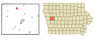
Oakland Acres is a city in Jasper County, Iowa, United States. The population was 176 at the time of the 2020 census.

<span class="mw-page-title-main">Minden, Iowa</span> City in Iowa, United States

Minden is a city in Pottawattamie County, Iowa, United States. The population was 600 at the time of the 2020 census. It has possessed a post office since 1875.

<span class="mw-page-title-main">Dixon, Iowa</span> City in Iowa, United States

Dixon is a city in Scott County, Iowa, United States. The population was 202 at the time of the 2020 census.

<span class="mw-page-title-main">Ramsey, Minnesota</span> City in Minnesota, United States

Ramsey is a suburban city 22 miles (35 km) north-northwest of downtown Minneapolis in Anoka County, Minnesota, United States. The population was 27,646 at the 2020 census. It is a northwest suburb of the Twin Cities.

<span class="mw-page-title-main">Vermillion, Minnesota</span> City in Minnesota, United States

Vermillion is a city in Dakota County, Minnesota, United States. The population was 441 at the 2020 census.

<span class="mw-page-title-main">Sunburg, Minnesota</span> City in Minnesota, United States

Sunburg is a city in Kandiyohi County, Minnesota, United States. The population was 100 at the 2010 census.

<span class="mw-page-title-main">Goodview, Minnesota</span> City in Minnesota, United States

Goodview is a city in Winona County, Minnesota, United States. The population was 4,158 at the 2020 census.

<span class="mw-page-title-main">Lakeshire, Missouri</span> City in Missouri, United States

Lakeshire is a city in St. Louis County, Missouri, United States. The population was 1,432 at the 2010 census.

<span class="mw-page-title-main">Lake Annette, Missouri</span> City in Missouri, United States

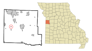
Lake Annette is a city in Cass County, Missouri, United States. The population was 100 at the 2010 census. It is part of the Kansas City metropolitan area.

<span class="mw-page-title-main">Houston Lake, Missouri</span> City in Missouri, United States

Houston Lake is a city in Platte County, Missouri, and is part of the Kansas City metropolitan area within the United States. The population was 235 at the 2010 census.

<span class="mw-page-title-main">Warwick, North Dakota</span> City in North Dakota, United States

Warwick is a city in Benson County, North Dakota, United States. The population was 55 at the 2020 census. Warwick was founded in 1907.

<span class="mw-page-title-main">Kramer, North Dakota</span> City in North Dakota, United States

Kramer is a city in Bottineau County, North Dakota, United States. The population was 24 at the 2020 census. Kramer was founded in 1905.

<span class="mw-page-title-main">Dunes City, Oregon</span> City in Oregon, United States

Dunes City is a city in Lane County, Oregon, United States. The population was 1,303 at the 2010 census.

<span class="mw-page-title-main">Junior, West Virginia</span> Town in West Virginia, United States

Junior is a town in Barbour County, West Virginia, United States, situated along the Tygart Valley River. The population was 384 at the 2020 census.

<span class="mw-page-title-main">Worthington, West Virginia</span> Town in West Virginia, United States

Worthington is a town in Marion County, West Virginia, United States. The population was 158 at the 2010 census. Worthington was incorporated in 1893 and named for Colonel George Worthington, an early settler. U.S. Route 19 passes through the town.

<span class="mw-page-title-main">War, West Virginia</span> City in West Virginia, United States

War is a city in McDowell County, West Virginia, United States. The population was 690 at the 2020 census. War was incorporated in 1920 by the Circuit Court of McDowell County. Its name is derived from War Creek, whose confluence with Dry Fork is located within the city. War is the only place in the United States with this name. War was formerly known as Miner's City. It is also known for being a setting in the movie October Sky; as writer Homer Hickam's Big Creek High School.

<span class="mw-page-title-main">North Hills, West Virginia</span> Town in West Virginia, United States

North Hills is a town in Wood County, West Virginia, United States. It is a suburb of Parkersburg. The population was 837 at the 2020 census. North Hills was incorporated on February 15, 1979.

References

  1. "ArcGIS REST Services Directory". United States Census Bureau. Retrieved September 20, 2022.
  2. 1 2 U.S. Geological Survey Geographic Names Information System: Cogswell, North Dakota
  3. 1 2 3 "Explore Census Data". United States Census Bureau . Retrieved July 14, 2022.
  4. 1 2 "City and Town Population Totals: 2020-2022". United States Census Bureau. December 7, 2023. Retrieved December 7, 2023.
  5. "US Gazetteer files 2010". United States Census Bureau. Archived from the original on July 2, 2012. Retrieved June 14, 2012.
  6. United States Census Bureau. "Census of Population and Housing" . Retrieved January 30, 2014.