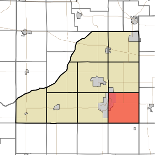
| Sargent Township, North Dakota | |
|---|---|
| Township | |
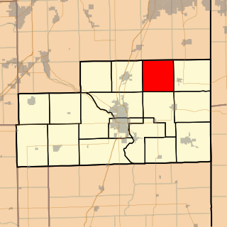
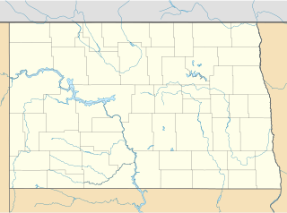
 Sargent Township, North Dakota Location within the state of North Dakota | |
| Coordinates: 46°5′16″N97°48′35″W / 46.08778°N 97.80972°W Coordinates: 46°5′16″N97°48′35″W / 46.08778°N 97.80972°W | |
| Country | United States |
| State | North Dakota |
| County | Sargent |
| Area | |
| • Total | 36.0 sq mi (93.2- km2) |
| • Land | 36.0 sq. mi. sq mi (93.2 - km2) |
| • Water | 0.1 sq mi (0.1 km2) |
| Elevation | 1,299 ft (396 m) |
| Population (2000) | |
| • Total | 49 |
| • Density | 1.8/sq mi (0.7/km2) |
| Time zone | Central (CST) (UTC-6) |
| • Summer (DST) | CDT (UTC-5) |
| ZIP code | 58017 |
| Area code(s) | 701 |
| FIPS code | 38-08980 [1] |
| GNIS feature ID | 1036788 [2] |
Sargent Township is a civil township in Sargent County, North Dakota, United States.
A civil township is a widely used unit of local government in the United States that is subordinate to a county. The term town is used in New England, New York, and Wisconsin to refer to the equivalent of the civil township in these states. Specific responsibilities and the degree of autonomy vary based on each state. Civil townships are distinct from survey townships, but in states that have both, the boundaries often coincide and may completely geographically subdivide a county. The U.S. Census Bureau classifies civil townships as minor civil divisions. Currently, there are 20 states with civil townships.

Sargent County is a county located in the U.S. state of North Dakota. As of the 2010 census, the population was 3,829. Its county seat is Forman. The county was formed in 1883.
North Dakota is a U.S. state in the midwestern and northern regions of the United States. It is the nineteenth largest in area, the fourth smallest by population, and the fourth most sparsely populated of the 50 states. North Dakota was admitted to the Union on November 2, 1889, along with its neighboring state, South Dakota. Its capital is Bismarck, and its largest city is Fargo.
Closest city is Cogswell, North Dakota, on the North border of the Township. Elevation in Sargent Township, North Dakota is 1,299.0 ft. (396.0 meters). Since 2000, it has had a population growth of -34.69 percent. There are 50 Farms in Sargent Township, North Dakota.

Cogswell is a city in Sargent County, North Dakota, United States. The population was 99 at the 2010 census. Cogswell was founded in 1890.
Continental Congress made a Land Ordinance on May 20, 1785, this Ordinance made a rectangular system for public land surveys. This was modified somewhat with the Land Act of 1796. The Land Ordinance made public lands in 30 states divided by lines using true North and South, with townships six miles square. The townships are then divided into 36 sections, each one mile square and containing approximately 640 acres in each section.

The Continental Congress, also known as the Philadelphia Congress, was a convention of delegates called together from the Thirteen Colonies. It became the governing body of the United States during the American Revolution. The Congress met from 1774 to 1789 in three incarnations. The first call for a convention was made over issues of the blockade and the Intolerable Acts penalizing the Province of Massachusetts Bay. In 1774 Benjamin Franklin convinced the colonial delegates to the Congress to form a representative body. Much of what we know today comes from the yearly log books printed by the Continental Congress called Resolutions, Acts and Orders of Congress, which gives a day-to-day description of debates and issues.

The Land Ordinance of 1785 was adopted by the United States Congress of the Confederation on May 20, 1785. It set up a standardized system whereby settlers could purchase title to farmland in the undeveloped west. Congress at the time did not have the power to raise revenue by direct taxation, so land sales provided an important revenue stream. The Ordinance set up a survey system that eventually covered over 3/4 of the area of the continental United States.
The Township as a large slough, Meszaros slough. Local cemeteries are Mount Calvary Cemetery and Nicholson Cemetery. Local lakes are Lake Schimmer and Lake Taayer.
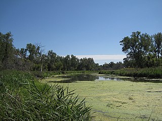
A slough is a wetland, usually a swamp or shallow lake, often a backwater to a larger body of water. Water tends to be stagnant or may flow slowly on a seasonal basis.

A lake is an area filled with water, localized in a basin, that is surrounded by land, apart from any river or other outlet that serves to feed or drain the lake. Lakes lie on land and are not part of the ocean, and therefore are distinct from lagoons, and are also larger and deeper than ponds, though there are no official or scientific definitions. Lakes can be contrasted with rivers or streams, which are usually flowing. Most lakes are fed and drained by rivers and streams.
United States House of Representative is North Dakota's At-large congressional district.