Coldingham Bay

Last updated

A panorama shot of Coldingham Sands from Homeli Knoll, the village of St Abbs is just visible over the headland. Coldingham Sands panorama 2.jpg
A panorama shot of Coldingham Sands from Homeli Knoll, the village of St Abbs is just visible over the headland.

Coldingham Bay is an inlet in the North Sea coast, just over three kilometres north of the town of Eyemouth in the Scottish Borders area of Scotland. It is situated at grid reference NT918666 and is easily reached by a minor road which leaves the B6438 road at Coldingham.

Contents

The Beach

Coldingham Sands is the name of the large beach in the Bay. It attracts many visitors, and on busy days there can be over 1000 visitors on the beach. [1] Coldingham Sands is a sandy seashore, which is a rare occurrence on Berwickshire's rocky coast. The beach was awarded the prestigious Blue Flag award in 2010 and has also received the Seaside Award which is for beaches that are more rural in character, being quieter and less developed. The Marine Conservation Society awarded the beach its top award for cleanliness in 2006, 2007, 2008, 2009 and 2010. There is a cafe, toilets, disabled access and car parking. [2]

The beach, which is approximately 200 metres wide, is well sheltered by headlands to the north and south (Yellow Craig Head), with rocky sections at both extremities of the sand. The beach is popular with surfers and bodyboarders, and a lifeguard attends the beach during busy summer periods. The north end of the beach has 55 beach huts, some of which are believed to be about 100 years old. The huts are leased from the Scottish Borders Council which owns the sands but not the huts. [3] At the top of the high ground above the huts are several private dwellings plus the Dunlaverock House hotel. [4] [5]

The north side of the beach showing the beach huts with the Dunlaverock House hotel and the St Abb's Haven Hotel above. Coldingham Sands.jpg
The north side of the beach showing the beach huts with the Dunlaverock House hotel and the St Abb’s Haven Hotel above.

The Bay and its surroundings

Coldingham Bay is situated within the St. Abbs and Eyemouth Voluntary Marine Reserve which itself is part of the Berwickshire and North Northumberland Coast Special Area of Conservation. The rocky shore around the bay has much marine life, with many types of sea creatures and seaweed to be found. The large area of tide pools is popular with rockpoolers. Slightly inland from the seashore is an area of dunes and grassland which provides a fragile habitat for a host of plants and animals. Visitors are requested to keep to the paths, not to pick flowers or light fires in this area to protect the environment.

The Berwickshire Coastal Path goes round the perimeter of the bay and provides walks that give easy access to St Abbs and Eyemouth. At the southern extremity of the beach lies Homeli Knoll (or Knowe), a steep-sided hillock which provides fine views of the beach area and along the coast. The south-facing slope of the Knoll has seen sightings of the small blue butterfly and its sole larval food plant kidney vetch (Anthyllis vulneraria) grows there. The north slope of the Knoll is a popular site for cowslip. [1] Milldown Burn flows into the southern part of the Bay and is its main inflowing water source, rising on Coldingham Moor and running for 6 km through the village of Coldingham before reaching the Bay. On the north side of the bay stands The Kip, an eight-metre-high sea stack which stands on dry land at low tide. At the southern extremity of the bay are the 30-metre-high grassy cliffs of Yellow Craig.

Other accommodation facilities for visitors to Coldingham Bay are available at the St Vedas Hotel which was built in 1897. The Coldingham Sands Youth Hostel, another late 19th-century house, was closed by the Scottish Youth Hostels Association in early 2008 after low visitor numbers deterred the investment needed to bring the hostel up to an acceptable standard. Local residents attempted to purchase the hostel under the Community Right to Buy legislation [6] in order to keep it open for visitors who bring trade to the area, but the application to purchase the former hostel was declined in February 2009 by Lottery Funds. [7] [8] The property was purchased by a property development company in 2010 and has since been converted into private housing accommodation. [9]

See also

Related Research Articles

Scottish Borders Council area of Scotland

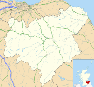
The Scottish Borders is one of 32 council areas of Scotland. It borders the City of Edinburgh, Dumfries and Galloway, East Lothian, Midlothian, South Lanarkshire, West Lothian and, to the south-west, south and east, the English counties of Cumbria and Northumberland. The administrative centre of the area is Newtown St Boswells.

Berwickshire Historic county in Scotland

Berwickshire is a historic county, registration county and lieutenancy area in southeastern Scotland, on the English border. It takes its name from Berwick-upon-Tweed, which was part of Scotland at the time of the county's formation, but became part of England in 1482 after several centuries of swapping back and forth between the two kingdoms.

Eyemouth Human settlement in Scotland

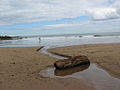
Eyemouth is a small town and civil parish in Berwickshire, in the Scottish Borders area of Scotland. It is 2 miles (3.2 km) east of the main north–south A1 road and just 8 miles (13 km) north of Berwick-upon-Tweed. It has a population of about 3,420 people (2004).

Calgary, Mull Human settlement in Scotland

Calgary is a hamlet on the northwest coast of the Isle of Mull, in Argyll and Bute, Scotland, United Kingdom. The hamlet is within the parish of Kilninian and Kilmore. It was the origin of the name of Fort Calgary in Canada, which became the city of Calgary, Alberta.

Eye Water

Eye Water is a river in the Scottish Borders, it flows in a general southeasterly direction from its source in the Lammermuir Hills to its estuary at Eyemouth on the east coast of Scotland, having a length of approximately 35 kilometres (22 mi).

St Abbs Village in Berwickshire, Scotland, UK

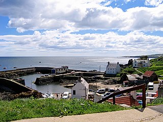
St Abbs is a small fishing village on the southeastern coast of Scotland, United Kingdom within the Coldingham parish of Berwickshire.

St Abbs Head

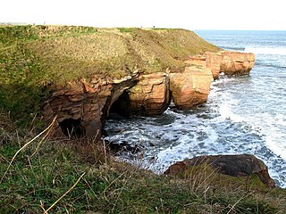
St Abb's Head is a rocky promontory by the village of St Abbs in Berwickshire, Scotland, and a national nature reserve administered by the National Trust for Scotland. St Abb's Head Lighthouse was designed and built by the brothers David Stevenson and Thomas Stevenson and began service on 24 February 1862.

Æbbe, also called Tabbs, was an Anglian abbess and noblewoman. She was the daughter of Æthelfrith, king of Bernicia from c. 593 to 616. She founded monasteries at Ebchester and St Abb's Head near Coldingham in Scotland.

Coldingham Human settlement in Scotland

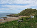
Coldingham is a village and parish in Berwickshire, Scottish Borders, on Scotland's southeast coastline, north of Eyemouth.

Abbey St Bathans

Abbey St Bathans is a parish in the Lammermuir district of Berwickshire, in the eastern part of the Scottish Borders. Unique in its topography, it is situated in a long winding steep wooded valley that follows the Whiteadder Water. The parish had a population of 106 at the 2011 Census.

Achmelvich Human settlement in Scotland

Achmelvich is a settlement situated in the Highland region of Scotland. The name comes from the Gaelic "Achadh" - a plain or meadow and "mealbhaich" - sandy dunes.

St. Abbs and Eyemouth Voluntary Marine Reserve is a Voluntary Marine Reserve—the first established in the United Kingdom. Located in the Scottish Borders, it covers 8 kilometres of the Berwickshire coast, from Eyemouth in the south to St. Abb's Head in the north. At its centre is the fishing village of St. Abbs.

Crystal Coast Coastal region of North Carolina, United States

In North Carolina, the Crystal Coast is an 85-mile stretch of coastline that extends from the Cape Lookout National Seashore, which includes 56 miles of protected beaches, southwestward to the New River. The Crystal Coast is a popular area with tourists and second-home owners in the summer.

A1107 road Road in Scotland

The A1107 is a road in south-east Scotland, in the Scottish Borders. It is a non-trunk route from near Cockburnspath to near Burnmouth.

Cove, Scottish Borders

Cove is a village in the Scottish Borders area of Scotland,18 mi (29 km) northwest of the Scotland/England border. It is about 36 miles southeast of Edinburgh and 8 mi (13 km) from Dunbar. Cove is close to Cockburnspath, Dunglass, Innerwick, Oldhamstocks, Bilsdean, and, further afield, Dunbar and Eyemouth. The climate is typical for Scotland, with cold, wet winters and variable summer weather, with days of rain and days of temperatures over 20 °C (68 °F).

Ross is a hamlet on the coast of the Scottish Borders area of Scotland, south of Burnmouth, in the parish of Ayton, and close to the A1.

Coldingham Loch

Coldingham Loch is a freshwater loch in the parish of Coldingham, in the Scottish Borders area of Scotland, in the former Berwickshire, between Coldingham Moor and St Abb's Head. The loch is a natural spring-fed 22-acre (8.9 ha) loch, about 300 yards (270 m) from the sea and about 300 feet (91 m) above sea level; it is used for fly fishing for rainbow trout and brown and blue trout. The area is also used for pheasant shooting.

Berwickshire Coastal Path Great Trail in Scotland, UK

The Berwickshire Coastal Path is a walking route some 48 kilometres (30 mi) long. It follows the eastern coastline of Scotland from Cockburnspath in the Scottish Borders to Berwick upon Tweed, just over the border in England. At Cockburnspath the path links with the Southern Upland Way and the John Muir Way.

Marshall Meadows Bay

Marshall Meadows Bay is the northernmost point of England. It is located on the Northumberland coast, 2+12 miles north of Berwick-upon-Tweed, and just to the south of the Anglo-Scottish border. Across the border in Scotland is the county of Berwickshire in the Borders region.
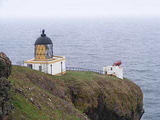
 The hamlet of Marshall Meadows lies to the west of the bay, and is the most northerly inhabited place in England. The Marshall Meadows Country House Hotel is here, along with a farm and a caravan site. There is a disused tunnel from the caravan site to the bay below, and there is a small cave 300 m (1,000 ft) north of this tunnel, plus another small cave just around the corner of Marshall Meadows Point. Nearby is the A1 trunk road and the East Coast Main Line railway.

References

  1. 1 2 Scottish Borders Council. Archived 6 June 2011 at the Wayback Machine Gives details of Homeli Knoll and states there are 55 beach huts and can be over 1000 daily visitors.
  2. Berwick News 2. Gives details of beach and award.
  3. Berwickshire News. Gives details of beach huts.
  4. "The Scottish Beach Award Guide" (leaflet) Gives general details on Coldingham Sands.
  5. Keep Scotland Beautiful. Archived 15 February 2012 at the Wayback Machine Gives details of Coldingham Sands.
  6. "Community Right To Buy". Scottish Government. Retrieved 17 September 2017.
  7. Berwickshire News. Gives details of possible community buyout of Youth Hostel.
  8. visitscotland.com. Archived 12 October 2008 at the Wayback Machine Gives general details of Youth Hostel.
  9. "Coldingham community fails in bid to purchase youth hostel". The Berwickshire News. Retrieved 17 September 2017.

Coordinates: 55°53′33″N2°07′58″W / 55.89246°N 2.13268°W / 55.89246; -2.13268