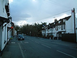
Colnbrook is a village in the Slough district in Berkshire, England. It lies within the historic boundaries of Buckinghamshire, and straddles two distributaries of the Colne, the Colne Brook and Wraysbury River. These two streams have their confluence just to the southeast of the village. Colnbrook is centred 3 miles (4.8 km) southeast of the Slough town centre, 4 miles (6.4 km) east of Windsor, and 19 miles (31 km) west of central London.

Wraysbury is a village and civil parish in the Royal Borough of Windsor and Maidenhead in England. It is under the western approach path of London Heathrow Airport. It is located on the east bank of the River Thames, roughly midway between Windsor and Staines-upon-Thames, and 18 miles (29 km) west by south-west of London. Historically part of Buckinghamshire, Wraysbury was made part of the new non-metropolitan county of Berkshire in 1974, under the Local Government Act 1972. The Wraysbury Reservoir is located to the east, administratively wholly in the Spelthorne district of Surrey, although it was historically divided between Buckinghamshire and Middlesex.
Horton is a village and civil parish in Berkshire, England. It is between Windsor and Staines-upon-Thames.

Poyle is a largely industrial and agricultural area in the unitary authority of Slough, in the ceremonial county of Berkshire, England. It is located 18.5 miles (30 km) west of Charing Cross in London and immediately west of the M25 motorway, near Heathrow Airport; it also adjoins the Colne Valley regional park.

The Colne is a river and a tributary of the River Thames in England. Just over half its course is in south Hertfordshire. Downstream, it forms the boundary between Buckinghamshire and the London Borough of Hillingdon. The confluence with the River Thames is on the Staines reach at Staines-upon-Thames.
Magna Carta Island is an ait in the River Thames in England, on the reach above Bell Weir Lock. It is in Berkshire facing water-meadows forming Runnymede. Its civil and ecclesiastical parish is Wraysbury so it was transferred from Buckinghamshire to Berkshire in 1974.

Longford is a suburban village in the London borough of Hillingdon, England. It is immediately northwest of London Heathrow Airport, which is in the same borough. It is the westernmost settlement in Greater London, very close to the borders of both Berkshire and Surrey.

The River Crane, a tributary of the River Thames, runs 8.5 miles (13.6 km) in West London, England. It forms the lower course of Yeading Brook. It adjoins or passes through three London boroughs: Hillingdon, Hounslow and Richmond upon Thames, in the historic county of Middlesex. The drainage basin is heavily urbanised but many of the Hayes to Whitton flood-meadows have been conserved, forming a narrow, green vale, opening out to what remains of Hounslow Heath in the centre – a near-continuous belt of semi-natural habitat.

The River Bourne or the Chertsey Bourne is in Berkshire and Surrey; it runs from sources in Windsor Great Park and Swinley Forest through to the River Thames.

The River Bourne is the name given to a Thames tributary in northwest Surrey, England which has a longer tributary, the Windle Brook, that rises nears Bagshot Park in the south of Swinley Forest, Berkshire, merging with it while flowing through villages north of Woking; downstream the Bourne joins the Thames near Weybridge.

The Staines Reservoirs are two large pumped storage reservoirs sitting to the east of the King George VI Reservoir near Heathrow airport in Surrey within the Colne Valley regional park. The village of Stanwell is mainly to the north east, and the town of Staines is to the south.
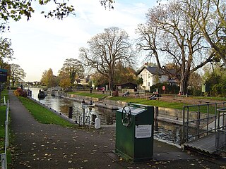
Penton Hook Lock is the sixth lowest lock of forty four on the non-tidal reaches of the River Thames in England. It faces an island which was until its construction a pronounced meander and is on the site of its seasonal cutoff. It is against the left bank marking the church parish medieval border of Laleham and Staines upon Thames in Surrey for many centuries. Until 1965 their county was Middlesex. At 266 ft (81 m) it is the third longest lock on the river.

Bell Weir Lock is a lock on the River Thames in England by the right bank, Runnymede which is a water meadow associated with Egham of importance for the constitutional Magna Carta. It is upstream of the terrace of a hotel and the a bridge designed by Edwin Lutyens who designed an ornamental park gate house along the reach. The bridge has been widened and carries the M25 and A30 road across the river in a single span. The lock was first built by the Thames Navigation Commission in 1817; it has one weir which is upstream. The lock is the eighth lowest of forty-five on the river and is named after the founder of the forerunner of the adjoining hotel who took charge of the lock and weir on its construction.
The Staines & West Drayton Railway (S&WDR) is a former railway on the western edge of London, England. It was about 5+1⁄2 miles (9 km) long and ran roughly north–south along the River Colne, parallel to the modern M25 motorway west of Heathrow Airport. It opened from West Drayton on the Great Western Main Line to Colnbrook in 1884 and reached Staines the next year.

The Maidenhead Waterways are a system of canals in Maidenhead, England. Formerly disused, plans to restore and upgrade them were announced in 2011. The works would initially make the waterways navigable by small craft, and over time by larger craft, as limitations to navigation are gradually removed.

Staines Moor is a 510.8-hectare (1,262-acre) biological Site of Special Scientific Interest north of Staines-upon-Thames in Surrey. It is part of the South West London Waterbodies Ramsar site and a Special Protection Area
The Wraysbury River is an anabranch of the River Colne to the west of London.

Frays River is a semi-canalised short river in England that branches off the River Colne at Uxbridge Moor and rejoins it at West Drayton. It is believed to be a mainly man-made anabranch north of the confluence with the River Pinn to feed watermills in the Parish of Hillingdon. The river is believed to be named after John Fray who owned Cowley Hall in the fifteenth century. Other names for the river are the Uxbridge and Cowley Mill Stream, the Cowley Stream or the Colham Mill Stream. Two of the three mills in Hillingdon Parish recorded in the Domesday book are believed to have been located on the southern section of the river.

The Colne Valley Regional Park is 43 square miles (110 km2) of parks, green spaces and reservoirs alongside the often multi-channel River Colne and parallel Grand Union Canal, mainly in Hertfordshire and Buckinghamshire, with parts in the London Borough of Hillingdon, Berkshire and a small area in Surrey.
 In the village of Colnbrook
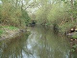 South of Colnbook
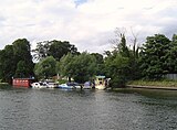 On discharge at the River Thames

