Colonia Federal

Last updated

Federal
Ciudad de Mexico - Nuestra Senora del Sagrado Corazon 0137.jpg
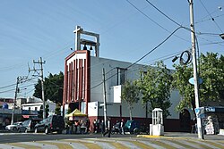
Our Lady of the Sacred Heart Church in the center of the neighborhood
Location map Mexico City.png
Red pog.svg
Federal
Coordinates: 19°25′12″N99°5′17″W / 19.42000°N 99.08806°W / 19.42000; -99.08806 Coordinates: 19°25′12″N99°5′17″W / 19.42000°N 99.08806°W / 19.42000; -99.08806
Country Mexico
City Mexico City
Borough Venustiano Carranza
Postal code
15700

Colonia Federal is a colonia in the Venustiano Carranza borough of Mexico City, just south of the Mexico City International Airport. The neighborhood is known for its particular shape that resembles a spider web.

Contents

History and design

The neighborhood was built on the Llanos de Balbuena, land previously owned by the Braniff family, a bourgeois family living in the country (Alberto Braniff, the first aviator of Latin America, was a member of it). [1] In 1908, the government of the country acquired 72 ha (180 acres) of land. The government considered creating a cemetery in the area, but since it was located far from the city center, the idea was discarded. After the end of the Mexican Revolution, around 1924, a prison was considered for construction. Instead, employees of the Secretariat of the Interior bought the land (then known as Cuatro Árboles) to build a neighborhood exclusively for civil servants. [2] On 24 October 1924, president Álvaro Obregón authorized the sale but regretted that despite its size, the site was not large enough to accommodate all the employees. Construction began on 8 February 1925 and eight days later the neighborhood was officially founded. [2]

Street names reference the cabinet of Mexico and other government dependencies. These include names such as Hacienda (Secretariat of Finance and Public Credit), Contraloría (Secretariat of Civil Service), or Trabajo (Secretariat of Labor and Social Welfare). [3] The radio-centric shape of the neighborhood, which resembles the design of a spider's web, is similar to that of Palmanova, a commune in Udine, Italy, or Place Charles de Gaulle, a road junction in Paris, France. By 1946, electricity was added to the area, drinking water pipes were installed in 1947, and by mid-century, the streets were paved. [2]

Points of interest

The neighborhood (center-left), next to the city's airport, as seen from an airplane. Aerial View of Mexico City Airport on 3.21.11.jpg
The neighborhood (center-left), next to the city's airport, as seen from an airplane.

In the middle, there is a roundabout (officially the Plaza del Poder Ejecutivo) with a culture center named Poliforum Cultural Colonia Federal. [2] In front of it, there is the Our Lady of the Sacred Heart Church (Parroquia de Nuestra Señora del Sagrado Corazón), which was built in 1962. [2]

Transportation

Colonia Federal is serviced by the Hangares metro station to the north and the Gómez Farías metro station to the south. [4] [5]

Related Research Articles

<span class="mw-page-title-main">Insurgentes metro station</span> Mexico City metro station

Insurgentes is a station on the Line 1 of Mexico City Metro. It is located within the Glorieta de los Insurgentes at the intersection of Avenida de los Insurgentes and Avenida Chapultepec in Mexico City's Cuauhtémoc borough, close to the Zona Rosa shopping and entertainment district and the Colonia Roma, two of the most iconic neighborhoods in the city. In 2019, the station had an average ridership of 65,134 passengers per day, making it the 12th busiest station in the network.

<span class="mw-page-title-main">Pantitlán metro station</span> Mexico City Metro station

Pantitlán metro station is a Mexico City Metro transfer station in the boroughs of Iztacalco and Venustiano Carranza, in Mexico City. It is a combined underground, at-grade, and elevated station with six island platforms and two side platforms, served by Lines 1, 5, 9, and A. The only quadra-line interchange station in the system, Pantitlán metro station works as the terminal station of all of the lines and is located adjacent to Zaragoza (Line 1), Hangares (Line 5), Puebla (Line 9), and Agrícola Oriental (Line A) stations. It serves the colonias (neighborhoods) of Ampliación Adolfo López Mateos, Aviación Civil, and Pantitlán; it receives its name from the last one. The station's pictogram features the silhouettes of two flagpoles.

<span class="mw-page-title-main">Zaragoza metro station (Mexico City)</span> Mexico City Metro station

Zaragoza metro station is a station of the Mexico City Metro in Venustiano Carranza, Mexico City. It is an underground station with two side platforms served by Line 1 between Gómez Farías and Pantitlán stations. It serves the colonias (neighborhoods) of 4 Árboles and Puebla. It lies below the Calzada Ignacio Zaragoza from which it receives its name, which in turn is named after Ignacio Zaragoza, the Secretary of War and Navy during the Battle of Puebla. The station's pictogram features a silhouette of the nearby equestrian statue that honors him.

<span class="mw-page-title-main">Aragón metro station</span> Mexico City Metro station

Aragón metro station is a Mexico City Metro station within the limits of Gustavo A. Madero and Venustiano Carranza, in Mexico City. It is an at-grade station with one island platform, served by Line 5, between Eduardo Molina and Oceanía stations. Aragón station serves the colonias of Casas Alemán and Simón Bolívar. The station is named after the San Juan de Aragón Park, and its pictogram represents the silhouette of a squirrel. Aragón metro station was opened on 19 December 1981, on the first day of the Consulado–Pantitlán service. In 2019, the station had an average daily ridership of 7,547 passengers, making it the 172nd busiest station in the network and the eighth busiest of the line.

<span class="mw-page-title-main">Boulevard Puerto Aéreo metro station</span> Mexico City Metro station

Boulevard Puerto Aéreo metro station is a station of the Mexico City Metro in Venustiano Carranza, Mexico City. It is an underground station with two side platforms served by Line 1 between Balbuena and Gómez Farías stations. It serves the colonias (neighborhoods) of Moctezuma, Santa Cruz Aviación, and Valentín Gómez Farías. It lies below Puerto Aéreo Boulevard, from which it receives its name, and it is near Calzada Ignacio Zaragoza. The station's pictogram features a silhouette of an air vent below a road bridge, in reference to a landmark found at the intersection of both avenues. The station is partially accessible for people with disabilities.

<span class="mw-page-title-main">Terminal Aérea metro station</span> Mexico City Metro station

Terminal Aérea metro station is a Mexico City Metro station next to the Mexico City International Airport in Venustiano Carranza, Mexico City. It is an underground station with two side platforms, served by Line 5, between Oceanía and Hangares stations. The station serves colonias (neighborhoods) of Peñón de los Baños and Moctezuma 2ª sección.

<span class="mw-page-title-main">Gómez Farías metro station</span> Mexico City Metro station

Gómez Farías metro station is a station of the Mexico City Metro in Venustiano Carranza, Mexico City. It is an underground station with two side platforms served by Line 1 between Boulevard Puerto Aéreo and Zaragoza stations. It serves the colonias (neighborhoods) of Federal and Gómez Farías; the station receives its name from the latter, which in turn is named after Valentín Gómez Farías, the seventh president of Mexico. The pictogram depicts a representation of the Mexican Constitution of 1857, which was promoted by Gómez Farías during his tenure as the president of Congress. Gómez Farías metro station opened on 4 September 1969 with service westward toward Chapultepec station and eastward toward Zaragoza station. The facilities are partially accessible for people with disabilities as it has escalators. In 2019, the station had an average daily ridership of 28,385 passengers, making it the 48th busiest station in the network and the 11th busiest of the line. Since 11 July 2022, the station has remained closed due to modernization works on the tunnel and the line's technical equipment.

<span class="mw-page-title-main">Potrero metro station</span> Mexico City Metro station

Potrero metro station is a station of the Mexico City Metro built along Insurgentes Norte Avenue in the colonias (neighborhoods) of Capultitlan and Guadalupe Insurgentes, in Gustavo A. Madero, Mexico City. It is an at-grade station with one island platform served by Line 3 between Deportivo 18 de Marzo and La Raza stations. The station and its surrounding area are named this way because there used to be a hippodrome during the Porfiriato era (1876–1911) and its pictogram features the silhouette of a head of a horse behind a fence. The station was opened on 1 December 1979, on the first day of service between Indios Verdes and Hospital General metro stations.

<span class="mw-page-title-main">Consulado metro station</span> Mexico City Metro station

Consulado metro station is a transfer station of the Mexico City Metro in Gustavo A. Madero and Venustiano Carranza, Mexico City. It is a combined elevated and at-grade station, along Lines 4 and 5. Consulado is located between Bondojito and Canal del Norte stations on Line 4, and between Valle Gómez and Eduardo Molina stations on Line 5. It serves the colonias of 7 de Noviembre, 20 de Noviembre, Felipe Ángeles, and Mártires de Río Blanco.

<span class="mw-page-title-main">Chilpancingo metro station</span> Mexico City metro station

Chilpancingo is an underground metro station along Line 9 of the Mexico City Metro. It is located in the Cuauhtémoc borough of Mexico City. It is very close to Metrobús station of the same name. In 2019, the station had an average ridership of 49,122 passengers per day, making it the busiest station in Line 9 and the 17th busiest station in the network.

<span class="mw-page-title-main">Misterios metro station</span> Mexico City Metro station

Misterios metro station is a Mexico City Metro station within the limits of Cuauhtémoc and Gustavo A. Madero, in Mexico City. It is an underground station with two side platforms, served by Line 5, between La Raza and Valle Gómez stations. Misterios station serves the colonias (neighborhoods) of Peralvillo and Vallejo.

<span class="mw-page-title-main">Valle Gómez metro station</span> Mexico City Metro station

Valle Gómez metro station is a Mexico City Metro station within the limits of Gustavo A. Madero and Venustiano Carranza, in Mexico City. It is an underground station with two side platforms, served by Line 5, between Misterios and Consulado stations. Valle Gómez station serves the colonias of 7 de Noviembre and Valle Gómez; the station receives its name from the latter. The station's pictogram features an agave plant. Valle Gómez metro station was opened on 1 July 1982, on the first day of the La Raza–Pantitlán service. In 2019, the station had an average daily ridership of 4,416 passengers, making it the 190th busiest station in the network and the least busy of the line.

<span class="mw-page-title-main">Eduardo Molina metro station</span> Mexico City Metro station

Eduardo Molina metro station is a Mexico City Metro station within the limits of Gustavo A. Madero and Venustiano Carranza, in Mexico City. It is an at-grade station with one island platform, served by Line 5, between Consulado and Aragón stations. Eduardo Molina station serves the colonias (neighborhoods) of 20 de Noviembre and Malinche. The station is named after Eduardo Molina Arévalo, an engineer who helped to solve the problem of water scarcity in the Valley of Mexico in the mid-20th century, and its pictogram represents two hands holding water, as featured on the mural El agua, origen de la vida, painted by Mexican muralist Diego Rivera in the Cárcamo de Dolores, in Chapultepec, Mexico City. Eduardo Molina metro station was opened on 19 December 1981, on the first day of the Consulado–Pantitlán service. In 2019, the station had an average daily ridership of 6,811 passengers, making it the 176th busiest station in the network and the ninth busiest of the line.

<span class="mw-page-title-main">Hangares metro station</span> Mexico City Metro station

Hangares metro station is a Mexico City Metro station in Venustiano Carranza, Mexico City. It is an underground station with two side platforms, served by Line 5, between Terminal Aérea and Pantitlán stations. Hangares metro station serves the colonia of Federal, located next to the Mexico City International Airport. The station was opened on 19 December 1981, on the first day of the then Consulado–Pantitlán service. The pictogram for the station features a biplane inside a hangar and its name is on account of its proximity to the airport's hangars. In 2019, the station had an average daily ridership of 4,856 passengers, making it the 188th busiest station in the network and the twelfth busiest of the line.

<span class="mw-page-title-main">Doctores metro station</span> Mexico City Metro station

Doctores metro station is a station of the Mexico City Metro in Cuauhtémoc, Mexico City. It is an underground station with two side platforms, served by Line 8, between Salto del Agua and Obrera stations. It serves the colonias (neighborhoods) of Doctores and Obrera, and its name is on account of its proximity to the first one, whose streets are primarily named after physicians; the pictogram depicts a couple of them. Doctores metro station opened on 20 July 1994 with service northward toward Garibaldi and southeastward toward Constitución de 1917 stations. In 2019, the station had an average daily ridership of 12,334 passengers, making it the 138th busiest station in the network and the twelfth busiest of the line.

<span class="mw-page-title-main">Cerro de la Estrella metro station</span> Mexico City metro station

Cerro de la Estrella is an underground station along Line 8 of the metro of Mexico City. The station is located along the Calzada Ermita-Iztapalapa and serves the Colonia Hidalgo y Mina neighborhood within the Iztapalapa borough on the east side of the city. The station is named for the Cerro de la Estrella – a mesoamerican archaeological site located nearby. It was opened on 20 July 1994.

<span class="mw-page-title-main">Múzquiz metro station</span> Mexico City Metro station

Múzquiz metro station is a station of the Mexico City Metro in the colonia (neighborhood) of Valle de Aragón 3a. Sección, in Ecatepec de Morelos, State of Mexico, in the metropolitan area of Mexico City. It is an at-grade station with one island platform served by Line B, between Ecatepec and Río de los Remedios stations. The name of the station references the nearby colonia of Melchor Múzquiz, which in turn was named after Melchor de Eca y Múzquiz, the fifth president of Mexico; its pictogram depicts a representation of his bust. The station was opened on 30 November 2000, on the first day of service between Ciudad Azteca and Buenavista stations. The facilities are partially accessible for people with disabilities as there are tactile pavings and braille signage plates. In 2019, Múzquiz metro station had an average daily ridership of 30,812 passengers, making it the third-most used on the line.

<span class="mw-page-title-main">Olímpica metro station</span> Mexico City Metro station

Olímpica metro station is a station of the Mexico City Metro in the colonias (neighborhoods) of Jardines de Aragón and La Olímpica II, in Ecatepec de Morelos, State of Mexico, in the metropolitan area of Mexico City. It is an at-grade station with one island platform served by Line B, between Plaza Aragón and Ecatepec stations. The name of the station references the colonia of the same name and its pictogram depicts the Olympic rings. The station was opened on 30 November 2000, on the first day of service between Ciudad Azteca and Buenavista metro stations. The facilities are accessible for people with disabilities as there are tactile pavings and braille signage plates. In 2019, Olímpica metro station had an average daily ridership of 16,745 passengers, making it the eleventh most used on the line.

<span class="mw-page-title-main">Plaza Aragón metro station</span> Mexico City Metro station

Plaza Aragón metro station is a station of the Mexico City Metro in the colonias (neighborhoods) of Ignacio Allende and Valle de Santiago, in Ecatepec de Morelos, State of Mexico, in the metropolitan area of Mexico City. It is an at-grade station with one island platform served by Line B, between Ciudad Azteca and Olímpica stations. The name of the station references colloquially the nearby Multiplaza Aragón shopping center; its pictogram depicts a representation of a stand of pots from a tianguis, an open-air market. The station was opened on 30 November 2000, on the first day of service between Ciudad Azteca and Buenavista metro stations. The facilities are accessible for people with disabilities as there are elevators, tactile pavings and braille signage plates. In 2019, Plaza Aragón metro station had an average daily ridership of 19,721 passengers, making it the tenth-most used on the line.

<span class="mw-page-title-main">Mexico City Metro Line 5</span> Metro line in Mexico City

Line 5, also known as the Yellow Line from its color on the system map, is a rapid transit line of the Mexico City Metro network. It travels 15.6 kilometers (9.7 mi) along the boroughs of Gustavo A. Madero, Cuauhtémoc and Venustiano Carranza in northern, northeastern and eastern Mexico City, serving thirteen stations. The line was inaugurated on 19 December 1981, going from Pantitlán to Consulado station. In 1982, the line was expanded twice, first from Consulado to La Raza station on 1 July, and later from La Raza to Politécnico station on 30 August.

References

  1. "Dónde está 'La Federal', la colonia inspirada en una comunidad francesa con forma de telaraña en la CDMX". Infobae (in Spanish). 24 June 2022. Retrieved 9 July 2022.
  2. 1 2 3 4 5 Plata Cruz, Patricia (18 May 2019). "La colonia con forma de telaraña". El Universal (in Spanish). Retrieved 9 July 2022.
  3. Gaona, Pável M. (30 May 2022). "La Federal: la historia detrás de nuestra colonia en forma de telaraña urbana 🕸️". Chilango (in Spanish). Retrieved 9 July 2022.
  4. "Hangares" (in Spanish). Sistema de Transporte Colectivo Metro. Archived from the original on 4 July 2020. Retrieved 9 July 2022.
  5. "Gómez Farías" (in Spanish). Sistema de Transporte Colectivo Metro. Archived from the original on 27 February 2021. Retrieved 9 July 2022.