Columbus Township, St. Clair County, Michigan

Last updated

Columbus Township, Michigan
Columbus Township (St. Clair), MI location.png
Location within St. Clair County
USA Michigan location map.svg
Red pog.svg
Columbus Township
Location within the state of Michigan
Coordinates: 42°51′16″N82°40′57″W / 42.85444°N 82.68250°W / 42.85444; -82.68250
CountryUnited States
State Michigan
County St. Clair
Organized1849
Government
  SupervisorBruce Christy
Area
  Total37.2 sq mi (96.4 km2)
  Land37.1 sq mi (96.1 km2)
  Water0.1 sq mi (0.4 km2)
Elevation
669 ft (204 m)
Population
 (2010)
  Total4,070
  Density109.7/sq mi (42.4/km2)
Time zone UTC-5 (Eastern (EST))
  Summer (DST) UTC-4 (EDT)
ZIP code(s)
48063
Area code 810
FIPS code 26-17520 [1]
GNIS feature ID1626123 [2]
Website Official website

Columbus Township is a civil township of St. Clair County in the U.S. state of Michigan. The population was 4,070 at the 2010 Census.

Contents

Communities

Geography

According to the United States Census Bureau, the township has a total area of 37.2 square miles (96 km2), of which 37.1 square miles (96 km2) is land and 0.1 square miles (0.26 km2) (0.38%) is water. The Belle River passes through the township and has two tributaries: Gillett Drain and Dawson Drain.

History

The creation of the Fort Gratiot Turnpike, now known as Gratiot Road, in 1832 led to the settlement of Columbus Township. Columbus Township was organized as a township on March 11, 1837. The Township was named for explorer Christopher Columbus, and Theodore Bethey served as the Township's first supervisor. In 1839 the Grand Trunk Western Railroad opened a small train station. In 1859, a 12-year-old Thomas Edison was given his first job, as a newsboy on the Grand Trunk Western Railroad line between Port Huron and Detroit. In 1992, the Richmond Area Historical and Genealogical Society moved the 1900-era Grand Trunk Railroad Depot located in Hickey to the nearby community of Richmond.

In 1845 the population was 315. In 1880, the township's population increased to 1,327, and by 2000 the population had grown to 4,615.

Demographics

As of the census [1] of 2000, there were 4,615 people, 1,533 households, and 1,266 families residing in the township. The population density was 124.4 inhabitants per square mile (48.0/km2). There were 1,595 housing units at an average density of 43.0 per square mile (16.6/km2). The racial makeup of the township was 97.01% White, 0.09% African American, 0.56% Native American, 0.37% Asian, 0.02% Pacific Islander, 0.69% from other races, and 1.26% from two or more races. Hispanic or Latino of any race were 2.30% of the population.

There were 1,533 households, out of which 42.7% had children under the age of 18 living with them, 71.5% were married couples living together, 7.2% had a female householder with no husband present, and 17.4% were non-families. 13.2% of all households were made up of individuals, and 3.8% had someone living alone who was 65 years of age or older. The average household size was 3.00 and the average family size was 3.29.

In the township the population was spread out, with 30.7% under the age of 18, 7.1% from 18 to 24, 32.1% from 25 to 44, 22.9% from 45 to 64, and 7.2% who were 65 years of age or older. The median age was 34 years. For every 100 females, there were 106.5 males. For every 100 females age 18 and over, there were 105.8 males.

The median income for a household in the township was $61,063, and the median income for a family was $65,000. Males had a median income of $46,824 versus $29,931 for females. The per capita income for the township was $21,767. About 2.5% of families and 3.7% of the population were below the poverty line, including 4.1% of those under age 18 and 2.8% of those age 65 or over.

Parks

The township has two parks. Columbus County Park is a 385-acre park that straddles Belle River. It offers fishing, hunting, hiking, sledding, kayaking, and horseback riding opportunities. It also includes a lodge. Funding to purchase Columbus County Park was made possible with a $2.23 million grant from the Michigan Natural Resources Trust Fund. [6] The township's other park is a small roadside park on Gratiot Avenue located alongside the Belle River.

Related Research Articles

<span class="mw-page-title-main">St. Clair County, Michigan</span> County in Michigan, United States

St. Clair County is a county located in the U.S. state of Michigan and bordering the west bank of the St. Clair River. As of the 2020 census, the population was 160,383. It is the 13th-most populous county in the state. The county seat is Port Huron, located at the north end of the St. Clair River at Lake Huron. The county was created September 10, 1820, and its government was organized in 1821. It is located northeast of Detroit and is included within the Detroit–Warren–Dearborn Metropolitan Statistical Area by the Office of Management and Budget. It is also consider by the State of Michigan to be a part of The Thumb, a peninsula that surrounded by Lake Huron in the east-central area of the state. This area is sometimes dubbed the Blue Water Area.

<span class="mw-page-title-main">Isabella County, Michigan</span> County in Michigan, United States

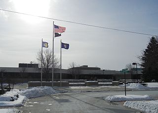
Isabella County is a county located in the U.S. state of Michigan. As of the 2020 Census, the population was 64,394. Its county seat is Mount Pleasant. The area was known as Ojibiway Besse, meaning "the place of the Ojibwa".

<span class="mw-page-title-main">Gratiot County, Michigan</span> County in Michigan, United States

Gratiot County is a county in the U.S. state of Michigan. As of the 2020 Census, the population was 41,761. The county seat is Ithaca, although its most populous city is Alma.

<span class="mw-page-title-main">Hume Township, Michigan</span> Civil township in Michigan, United States

Hume Township is a civil township of Huron County in the U.S. state of Michigan. As of the 2000 census, the township population was 801.

<span class="mw-page-title-main">Huron Township, Michigan</span> Civil township in Michigan, United States

Huron Township is a civil township of Huron County in the U.S. state of Michigan. The population was 423 at the 2000 census.

<span class="mw-page-title-main">Sherman Township, Huron County, Michigan</span> Civil township in Michigan, United States

Sherman Township is a civil township of Huron County in the U.S. state of Michigan. The population was 1,083 at the 2010 census.

<span class="mw-page-title-main">Cohoctah Township, Michigan</span> Civil township in Michigan, United States

Cohoctah Township is a civil township of Livingston County in the U.S. state of Michigan. The population was 3,317 at the 2010 census. It is located in the northwest quadrant of the county, bordered by Conway Township to the west, Deerfield Township to the east, and Howell Township to the south. To the north is Shiawassee County.

<span class="mw-page-title-main">Clinton Township, Macomb County, Michigan</span> Charter township in Michigan, United States

Clinton Township is a charter township in Macomb County in the U.S. state of Michigan. As a northern suburb of Metro Detroit, Clinton is about 22 miles (35 km) northeast of downtown Detroit. As of the 2020 census, the township had a population of 100,513, making it the most populous township in the state.

<span class="mw-page-title-main">Roseville, Michigan</span> City in Michigan, United States

Roseville is a city in Macomb County in the U.S. state of Michigan. A northern suburb of Detroit, Roseville is located roughly 13 miles (20.9 km) northeast of downtown Detroit. As of the 2020 census, the city had a population of 47,710.

<span class="mw-page-title-main">Berlin Charter Township, Michigan</span> Charter township in Michigan, United States

Berlin Charter Township is a charter township of Monroe County in the U.S. state of Michigan. At the 2010 census, the township population was 9,299.

<span class="mw-page-title-main">Carsonville, Michigan</span> Village in Michigan, United States

Carsonville is a village in Sanilac County of the U.S. state of Michigan. The population was 527 at the 2010 census. The village is situated at 43°25′37″N82°40′17″W on the boundary between Bridgehampton Township and Washington Township, with about half the village in each.

<span class="mw-page-title-main">Algonac, Michigan</span> City in Michigan, United States

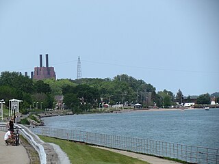
Algonac is a city in St. Clair County of the U.S. state of Michigan. The population was 4,196 at the 2020 census.

<span class="mw-page-title-main">Fort Gratiot Township, Michigan</span> Charter township in Michigan, United States

Fort Gratiot Township is a charter township of St. Clair County in the U.S. state of Michigan. The population was 11,108 at the 2010 Census. It is named for Fort Gratiot, an American fort located there off and on between 1814 and 1879.

<span class="mw-page-title-main">Marysville, Michigan</span> City in Michigan, United States

<span class="mw-page-title-main">Port Huron Township, Michigan</span> Charter township in Michigan, United States

Port Huron Charter Township is a charter township of St. Clair County in the U.S. state of Michigan. The population was 10,654 at the 2010 Census. The city of Port Huron is adjacent to the township.

<span class="mw-page-title-main">Riley Township, St. Clair County, Michigan</span> Civil township in Michigan, United States

Riley Township is a civil township of St. Clair County in the U.S. state of Michigan. The population was 3,353 at the 2010 Census.

<span class="mw-page-title-main">St. Clair Township, Michigan</span> Civil township in Michigan, United States

St. Clair Township is a civil township of St. Clair County in the U.S. state of Michigan. The population was 6,817 at the 2010 Census. The city of St. Clair is located near the southeast corner of the township.

<span class="mw-page-title-main">Wales Township, Michigan</span> Civil township in Michigan, United States

Wales Township is a civil township of St. Clair County in the U.S. state of Michigan. The population was 3,248 at the 2010 Census.

<span class="mw-page-title-main">Ypsilanti Charter Township, Michigan</span> Charter township in Michigan, United States

Ypsilanti Charter Township is a charter township of Washtenaw County in the U.S. state of Michigan. The population was 53,362 at the 2010 census. The city of Ypsilanti is mostly surrounded by the township, but the two are administered autonomously.

<span class="mw-page-title-main">Richmond, Michigan</span> City in Michigan, United States

Richmond is a city within Metro Detroit in the U.S. state of Michigan. The population was 5,878 at the 2020 census. Most of the city is located in Macomb County, though there is a small portion in neighboring St. Clair County.

References

  1. 1 2 "U.S. Census website". United States Census Bureau . Retrieved January 31, 2008.
  2. U.S. Geological Survey Geographic Names Information System: Columbus Township, St. Clair County, Michigan
  3. U.S. Geological Survey Geographic Names Information System: Belle River, Michigan
  4. U.S. Geological Survey Geographic Names Information System: Columbus, Michigan
  5. U.S. Geological Survey Geographic Names Information System: Snyderville, Michigan
  6. "Columbus Park Overview" (PDF). Archived from the original (PDF) on September 9, 2013. Retrieved January 2, 2014.