Port Huron Township, Michigan

Last updated
Port Huron Charter Township, Michigan
Port Huron Charter Township, MI location.png
Location within St. Clair County
USA Michigan location map.svg
Red pog.svg
Port Huron Township
Location within the state of Michigan
Coordinates: 42°58′01″N82°28′15″W / 42.96694°N 82.47083°W / 42.96694; -82.47083 Coordinates: 42°58′01″N82°28′15″W / 42.96694°N 82.47083°W / 42.96694; -82.47083
Country United States
State Michigan
County St. Clair
Established1827
Government
  SupervisorRobert Lewandowski, Jr.
Area
  Total13.1 sq mi (33.9 km2)
  Land12.9 sq mi (33.5 km2)
  Water0.2 sq mi (0.5 km2)
Elevation
627 ft (191 m)
Population
 (2010)
  Total10,654
  Density825.9/sq mi (318/km2)
Time zone UTC-5 (Eastern (EST))
  Summer (DST) UTC-4 (EDT)
ZIP code(s)
48060
Area code 810
FIPS code 26-65840 [1]
GNIS feature ID1626933 [2]
Website Official website

Port Huron Charter Township is a charter township of St. Clair County in the U.S. state of Michigan. The population was 10,654 at the 2010 Census. The city of Port Huron is adjacent to the township.

Contents

Communities

There are two unincorporated communities in the township: [3]

Geography

According to the United States Census Bureau, the township has a total area of 13.1 square miles (34 km2), of which 12.9 square miles (33 km2) is land and 0.2 square miles (0.52 km2) (1.37%) is water.

Demographics

As of the census [1] of 2000, there were 8,615 people, 3,310 households, and 2,442 families residing in the township. The population density was 666.6 inhabitants per square mile (257.4/km2). There were 3,478 housing units at an average density of 269.1 per square mile (103.9/km2). The racial makeup of the township was 93.63% White, 3.46% African American, 0.62% Native American, 0.35% Asian, 0.02% Pacific Islander, 0.62% from other races, and 1.31% from two or more races. Hispanic or Latino of any race were 2.46% of the population.

There were 3,310 households, out of which 34.2% had children under the age of 18 living with them, 58.2% were married couples living together, 11.7% had a female householder with no husband present, and 26.2% were non-families. 20.6% of all households were made up of individuals, and 7.3% had someone living alone who was 65 years of age or older. The average household size was 2.58 and the average family size was 2.97.

In the township the population was spread out, with 25.8% under the age of 18, 7.7% from 18 to 24, 30.4% from 25 to 44, 23.6% from 45 to 64, and 12.5% who were 65 years of age or older. The median age was 37 years. For every 100 females, there were 97.3 males. For every 100 females age 18 and over, there were 95.0 males.

The median income for a household in the township was $43,978, and the median income for a family was $50,978. Males had a median income of $44,024 versus $23,478 for females. The per capita income for the township was $21,583. About 4.9% of families and 7.4% of the population were below the poverty line, including 7.9% of those under age 18 and 5.7% of those age 65 or over.

Related Research Articles

<span class="mw-page-title-main">St. Clair County, Michigan</span> County in Michigan, United States

St. Clair County is a county located in the U.S. state of Michigan and bordering the west bank of the St. Clair River. As of the 2020 Census, the population was 160,383. It is the 13th-most populous county in the state. The county seat is Port Huron, located at the north end of the St. Clair River at Lake Huron. The county was created September 10, 1820, and its government was organized in 1821. It is located northeast of Detroit. Geographically, it lies in the Thumb area of eastern Michigan.

Walton Township is a civil township of Eaton County in the U.S. state of Michigan. The population was 2,011 at the 2000 census.

<span class="mw-page-title-main">Bloomfield Township, Huron County, Michigan</span> Civil township in Michigan, United States

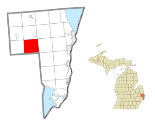
Bloomfield Township is a civil township of Huron County in the U.S. state of Michigan. As of the 2000 census, the township population was 535.

<span class="mw-page-title-main">Caseville Township, Michigan</span> Civil township in Michigan, United States

Caseville Township is a civil township of Huron County in the U.S. state of Michigan. The population was 2,723 at the 2000 census.

<span class="mw-page-title-main">Huron Township, Michigan</span> Civil township in Michigan, United States

Huron Township is a civil township of Huron County in the U.S. state of Michigan. The population was 423 at the 2000 census.

<span class="mw-page-title-main">Port Austin Township, Michigan</span> Civil township in Michigan, United States

Port Austin Township is a civil township of Huron County in the U.S. state of Michigan. The population was 1,591 at the 2000 census.

<span class="mw-page-title-main">Port Hope, Michigan</span> Village in Michigan, United States

Port Hope is a village in Huron County of the U.S. state of Michigan. The population was 267 at the 2010 census. The village is within Rubicon Township.

<span class="mw-page-title-main">Sand Beach Township, Michigan</span> Civil township in Michigan, United States

Sand Beach Township is a civil township of Huron County in the U.S. state of Michigan. The population was 1,470 at the 2000 census.

<span class="mw-page-title-main">Sheridan Township, Huron County, Michigan</span> Civil township in Michigan, United States

Sheridan Township is a civil township of Huron County in the U.S. state of Michigan. The population was 736 at the 2000 census.

<span class="mw-page-title-main">Sherman Township, Huron County, Michigan</span> Civil township in Michigan, United States

Sherman Township is a civil township of Huron County in the U.S. state of Michigan. The population was 1,083 at the 2010 census.

<span class="mw-page-title-main">Clinton Township, Macomb County, Michigan</span> Charter township in Michigan, United States

Clinton Township, officially the Charter Township of Clinton, is a charter township of Macomb County in the U.S. state of Michigan. As of the 2020 census, the township had a total population of 100,513. It ranks as Michigan's most-populated township and 8th most-populated municipality overall.

<span class="mw-page-title-main">Berlin Charter Township, Michigan</span> Charter township in Michigan, United States

Berlin Charter Township is a charter township of Monroe County in the U.S. state of Michigan. At the 2010 census, the township population was 9,299.

Port Sheldon Township is a civil township of Ottawa County in the U.S. state of Michigan. As of the 2000 census, the township population was 4,503. As of the 2006 census estimates, the population was 4,678.

Bridgehampton Township is a civil township of Sanilac County in the U.S. state of Michigan. As of the 2000 census, the township population was 911.

<span class="mw-page-title-main">Columbus Township, St. Clair County, Michigan</span> Civil township in Michigan, United States

Columbus Township is a civil township of St. Clair County in the U.S. state of Michigan. The population was 4,070 at the 2010 Census.

<span class="mw-page-title-main">Fort Gratiot Township, Michigan</span> Charter township in Michigan, United States

Fort Gratiot Township is a charter township of St. Clair County in the U.S. state of Michigan. The population was 11,108 at the 2010 Census. It is named for Fort Gratiot, an American fort located there off and on between 1814 and 1879.

<span class="mw-page-title-main">Kimball Township, Michigan</span> Civil township in Michigan, United States

Kimball Township is a civil township of St. Clair County in the U.S. state of Michigan. As of the 2010 census, the township population was 9,358.

<span class="mw-page-title-main">Riley Township, St. Clair County, Michigan</span> Civil township in Michigan, United States

Riley Township is a civil township of St. Clair County in the U.S. state of Michigan. The population was 3,353 at the 2010 Census.

<span class="mw-page-title-main">Wales Township, Michigan</span> Civil township in Michigan, United States

Wales Township is a civil township of St. Clair County in the U.S. state of Michigan. The population was 3,248 at the 2010 Census.

<span class="mw-page-title-main">Kenockee Township, Michigan</span> Civil township in Michigan, United States

Kenockee Township is a civil township of St. Clair County in the U.S. state of Michigan. The population was 2,470 at the 2010 Census.

References

  1. 1 2 "U.S. Census website". United States Census Bureau . Retrieved 2008-01-31.
  2. U.S. Geological Survey Geographic Names Information System: Port Huron Township, Michigan
  3. "St. Clair County" (PDF). County Maps. Michigan Department of Technology, Management, and Budget. Archived (PDF) from the original on 2006-05-10. Retrieved 1 February 2012.
  4. U.S. Geological Survey Geographic Names Information System: South Park, Michigan & Google Map
  5. U.S. Geological Survey Geographic Names Information System: Tappan, Michigan & Google Map