Emmett, Michigan

Last updated

Emmett, Michigan
Emmett (village), MI location.png
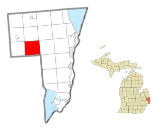
Location within St. Clair County
USA Michigan location map.svg
Red pog.svg
Emmett
Location within the state of Michigan
Coordinates: 42°59′42″N82°45′46″W / 42.99500°N 82.76278°W / 42.99500; -82.76278
Country United States
State Michigan
County St. Clair
Township Emmett
Area
[1]
  Total1.50 sq mi (3.88 km2)
  Land1.50 sq mi (3.88 km2)
  Water0.00 sq mi (0.00 km2)
Elevation
774 ft (236 m)
Population
 (2020)
  Total258
  Density172.11/sq mi (66.46/km2)
Time zone UTC-5 (Eastern (EST))
  Summer (DST) UTC-4 (EDT)
ZIP code(s)
48022
Area code 810
FIPS code 26-25940 [2]
GNIS feature ID1624511 [3]

Emmett is a village in St. Clair County of the U.S. state of Michigan. The population was 269 at the 2010 census. The village is located within Emmett Township.

Contents

Geography

According to the United States Census Bureau, the village has a total area of 1.51 square miles (3.91 km2), all land. [4] Emmett is located just north of Interstate 69 and is in the central part of St. Clair County.

Demographics

Historical population
CensusPop.Note
1900 265
1910 29210.2%
1920 175−40.1%
1930 19913.7%
1940 22915.1%
1950 2300.4%
1960 28323.0%
1970 2974.9%
1980 285−4.0%
1990 2974.2%
2000 251−15.5%
2010 2697.2%
2020 258−4.1%
U.S. Decennial Census [5]

2010 census

As of the census [6] of 2010, there were 269 people, 91 households, and 74 families living in the village. The population density was 178.1 inhabitants per square mile (68.8/km2). There were 96 housing units at an average density of 63.6 per square mile (24.6/km2). The racial makeup of the village was 93.7% White, 0.7% Asian, 0.7% Pacific Islander, 3.3% from other races, and 1.5% from two or more races. Hispanic or Latino of any race were 3.3% of the population.

There were 91 households, of which 37.4% had children under the age of 18 living with them, 64.8% were married couples living together, 11.0% had a female householder with no husband present, 5.5% had a male householder with no wife present, and 18.7% were non-families. 16.5% of all households were made up of individuals, and 8.8% had someone living alone who was 65 years of age or older. The average household size was 2.96 and the average family size was 3.26.

The median age in the village was 38.4 years. 29% of residents were under the age of 18; 5.3% were between the ages of 18 and 24; 23.7% were from 25 to 44; 26.8% were from 45 to 64; and 15.2% were 65 years of age or older. The gender makeup of the village was 53.2% male and 46.8% female.

2000 census

As of the census [2] of 2000, there were 251 people, 87 households, and 66 families living in the village. The population density was 168.4 inhabitants per square mile (65.0/km2). There were 93 housing units at an average density of 62.4 per square mile (24.1/km2). The racial makeup of the village was 99.60% White and 0.40% Native American. Hispanic or Latino of any race were 0.40% of the population.

Many of the residents of Emmett have Irish heritage, most of which can trace family members back to Ireland.

There were 87 households, out of which 32.2% had children under the age of 18 living with them, 66.7% were married couples living together, 6.9% had a female householder with no husband present, and 23.0% were non-families. 20.7% of all households were made up of individuals, and 2.3% had someone living alone who was 65 years of age or older. The average household size was 2.89 and the average family size was 3.42.

In the village, the population was spread out, with 30.3% under the age of 18, 8.8% from 18 to 24, 29.1% from 25 to 44, 20.7% from 45 to 64, and 11.2% who were 65 years of age or older. The median age was 35 years. For every 100 females, there were 100.8 males. For every 100 females age 18 and over, there were 103.5 males.

The median income for a household in the village was $50,536, and the median income for a family was $52,250. Males had a median income of $41,563 versus $22,188 for females. The per capita income for the village was $16,500. None of the families and 1.2% of the population were living below the poverty line.

Economy

The surrounding community is mostly agricultural. Emmett houses the Eastern Michigan Grain Elevator, the largest in St. Clair County, Michigan. It has recently merged with Star of the West Milling Co. of Vassar and Cass City. Most of the population commutes to larger cities such as Richmond, Port Huron, and Imlay City.

Related Research Articles

<span class="mw-page-title-main">Lenzburg, Illinois</span> Village in Illinois, United States

Lenzburg is a village in St. Clair County, Illinois, USA. The population was 521 at the 2010 census.

<span class="mw-page-title-main">Emmett, Kansas</span> City in Pottawatomie County, Kansas

Emmett is a city in Pottawatomie County, Kansas, United States. As of the 2020 census, the population of the city was 170.

<span class="mw-page-title-main">Almont, Michigan</span> Village in Michigan, United States

Almont is a village in Almont Township, Lapeer County, Michigan. Its population was 2,846 at the 2020 census.

<span class="mw-page-title-main">Capac, Michigan</span> Village in Michigan, United States

Capac is a village in Mussey Township, St. Clair County in the U.S. state of Michigan. The population was 1,890 at the 2010 census.

<span class="mw-page-title-main">Emmett Township, St. Clair County, Michigan</span> Civil township in Michigan, United States

Emmett Township is a civil township of St. Clair County in the U.S. state of Michigan. The population was 2,515 at the 2020 Census. The village of Emmett is located within the township. Emmett Township was set off from Clyde Township in 1850. It is named for Irish patriot Robert Emmet.
<span class="mw-page-title-main">Riley Township, St. Clair County, Michigan</span> Civil township in Michigan, United States

Riley Township is a civil township of St. Clair County in the U.S. state of Michigan. The population was 3,199 at the 2020 Census.

<span class="mw-page-title-main">Yale, Michigan</span> City in Michigan, United States

Yale is a city in St. Clair County in the U.S. state of Michigan. The population was 1,955 at the 2010 census. Yale is considered unofficially as the Bologna Capital of the world, in part due to its Yale Bologna Festival, which began in 1989. Yale bologna is sold in grocery stores throughout the area. Yale is also home to the Yale Airport which is just south of town on Brockway Rd.

<span class="mw-page-title-main">St. Clair, Minnesota</span> City in Minnesota, United States

St. Clair or Saint Clair is a city in Blue Earth County, Minnesota, United States, located along the Le Sueur River. The population was 750 at the 2020 census. It is part of the Mankato-North Mankato Metropolitan Statistical Area.

<span class="mw-page-title-main">Parkway, Missouri</span> Village in Missouri, United States

Parkway is a village in Franklin County, Missouri, United States. The population was 439 at the 2010 census.

<span class="mw-page-title-main">Collins, Missouri</span> Village in Missouri, United States

Collins is a village in St. Clair County, Missouri, United States. The population was 125 at the 2020 census.

<span class="mw-page-title-main">Gerster, Missouri</span> Town in Missouri, United States

Gerster is a town in St. Clair County, Missouri, United States. The population was 21 at the 2020 census.

<span class="mw-page-title-main">Roscoe, Missouri</span> Village in Missouri, United States

Roscoe is a village in St. Clair County, Missouri, United States. The population was 89 at the 2020 census.

<span class="mw-page-title-main">Innsbrook, Missouri</span> Village in Missouri, United States

Innsbrook is a village in Warren County, Missouri, United States. The population was 552 at the 2010 census. The village of Innsbrook is comprised almost entirely by Innsbrook Resort—a private, gated community. The village was founded in 1998.

<span class="mw-page-title-main">Colon, Nebraska</span> Village in Saunders County, Nebraska, United States

Colon is a village in Saunders County, Nebraska, United States. The population was 107 at the 2020 census. Amenities include a post office and bank branch. Colon is seven miles north of the county seat Wahoo.

<span class="mw-page-title-main">North Hampton, Ohio</span> Village in Ohio, United States

North Hampton is a village in Clark County, Ohio, United States. The population was 457 at the 2020 census. It is part of the Springfield, Ohio Metropolitan Statistical Area.
<span class="mw-page-title-main">Newtown, Ohio</span> Village in Ohio, United States

Newtown is a village in southeastern Hamilton County, Ohio, United States, near Cincinnati. The population was 2,702 at the 2020 census. Newtown was settled in 1792 and incorporated as a village in 1901.

Spring Ridge is a census-designated place (CDP) in Spring Township, Berks County, Pennsylvania, United States. The population was 1,003 at the 2010 census.

Norris is a town in Pickens County, South Carolina, United States. The population was 813 at the 2010 census. It is part of the Greenville–Mauldin–Easley Metropolitan Statistical Area.

<span class="mw-page-title-main">North Bay, Wisconsin</span> Village in Wisconsin, United States

North Bay is a village in Racine County, Wisconsin, United States. The population was 209 at the 2020 census.

<span class="mw-page-title-main">Memphis, Michigan</span> City in Michigan, United States

Memphis is a city that straddles the border between Macomb and St. Clair counties in the U.S. state of Michigan. The population was 1,084 at the 2020 census.

References

  1. "2020 U.S. Gazetteer Files". United States Census Bureau. Retrieved May 21, 2022.
  2. 1 2 "U.S. Census website". United States Census Bureau . Retrieved January 31, 2008.
  3. "US Board on Geographic Names". United States Geological Survey. October 25, 2007. Retrieved January 31, 2008.
  4. "US Gazetteer files 2010". United States Census Bureau. Archived from the original on January 25, 2012. Retrieved November 25, 2012.
  5. "Census of Population and Housing". Census.gov. Retrieved June 4, 2015.
  6. "U.S. Census website". United States Census Bureau . Retrieved November 25, 2012.

42°59′26″N82°45′54″W / 42.99056°N 82.76500°W / 42.99056; -82.76500