Related Research Articles

Shenandoah County is a county located in the Commonwealth of Virginia. As of the 2020 United States Census, the population was 44,186. Its county seat is Woodstock. It is part of the Shenandoah Valley region of Virginia.

Berryville is an incorporated town in and the county seat of Clarke County, Virginia, United States. The population was 4,574 at the 2020 census, up from 4,185 at the 2010 census.

Seven Corners is a commercial center and census-designated place (CDP) in Fairfax County, Virginia, United States. The population was 9,255 at the 2010 census. Seven Corners has a "Falls Church" mailing address but is not within Falls Church's city limits. The area got its name from the intersection of State Route 7, U.S. Route 50, State Route 613, State Route 338 and Wilson Boulevard. The junction of these four roads once created seven corners.

The Shenandoah River is the principal tributary of the Potomac River, 55.6 miles (89.5 km) long with two forks approximately 100 miles (160 km) long each, in the U.S. states of Virginia and West Virginia. The river and its tributaries drain the central and lower Shenandoah Valley and the Page Valley in the Appalachians on the west side of the Blue Ridge Mountains, in northwestern Virginia and the Eastern Panhandle of West Virginia. There is a hydroelectric plant along the Shenandoah river constructed in 2014 by Dominion.

U.S. Route 522 is a spur route of US 22 in the states of Virginia, West Virginia, Maryland, and Pennsylvania. The U.S. Highway travels in a north-south direction, and runs 308.59 miles (496.63 km) from US 60 near Powhatan, Virginia, to its northern terminus at US 11 and US 15 near Selinsgrove, Pennsylvania. US 522 serves many small cities and towns in the Piedmont, Blue Ridge Mountains, and northern Shenandoah Valley of Virginia. The highway serves the Virginia communities of Goochland, Mineral, Culpeper, the town of Washington, and Front Royal and the independent city of Winchester. US 522 then follows the Ridge-and-Valley Appalachians north and then east through the Eastern Panhandle of West Virginia, a 2-mile-wide (3.2 km) stretch of Western Maryland, and South Central Pennsylvania to its terminus in the Susquehanna Valley. The highway serves Berkeley Springs, West Virginia; Hancock, Maryland; and the Pennsylvania communities of McConnellsburg, Mount Union, Lewistown, and Middleburg.

U.S. Route 340 is a spur route of US 40, and runs from Greenville, Virginia to Frederick, Maryland. In Virginia, it runs north–south, parallel and east of US 11, from US 11 north of Greenville via Waynesboro, Grottoes, Elkton, Luray, Front Royal, and Berryville to the West Virginia state line. A short separate piece crosses northern Loudoun County on its way from West Virginia to Maryland.

Virginia State Route 7 (VA 7) is a major primary state highway and busy commuter route in northern Virginia, United States. It travels southeast from downtown Winchester to SR 400 in downtown Alexandria. Its route largely parallels those of the Washington & Old Dominion Trail and the Potomac River. Between its western terminus and Interstate 395 (I-395), SR 7 is part of the National Highway System. In 1968, the Virginia State Highway Commission designated the road as the "Harry Flood Byrd Highway" between Alexandria and Winchester to commemorate Harry F. Byrd Sr. (1887–1966).
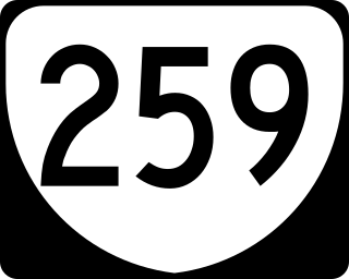
State Route 259 is a primary state highway in the U.S. state of Virginia. The state highway runs a total of 26.80 miles (43.13 km) in two sections. The southern section, in northern Rockingham County, has a length of 21.81 miles (35.10 km) from Interstate 81 (I-81) and U.S. Route 11 at Mauzy through Broadway to the West Virginia state line into Mathias. The northern section, in western Frederick County, covers 4.99 miles (8.03 km) from the West Virginia state line north to US 50 at Gore. The two sections of SR 259 are joined by West Virginia Route 259.
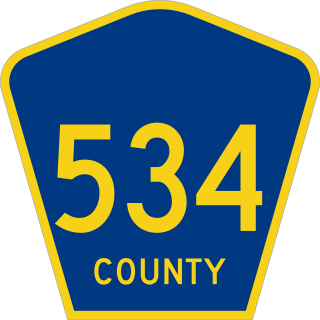
County Route 534 is a county highway in the U.S. state of New Jersey. The highway extends 22.86 miles (36.79 km) from Cooper Street on the border of Woodbury and Deptford Township to Indian Mills Road in Shamong Township.

State Route 228 (SR 228), also known as Jiggs Highway, is a 20.803-mile (33.479 km) state highway in Elko County, Nevada, United States, that connects Jiggs with Nevada State Route 227 in Spring Creek.

U.S. Highway 1 (US 1) in Florida runs 545 miles (877 km) along the state's east coast from Key West to its crossing of the St. Marys River into Georgia north of Boulogne and south of Folkston. US 1 was designated through Florida when the U.S. Numbered Highway System was established in 1926. The road is maintained by the Florida Department of Transportation (FDOT).

State Route 175 (SR 175) is a primary state highway in the U.S. state of Virginia. Known as Chincoteague Road, the state highway runs 10.49 miles (16.88 km) from U.S. Route 13 (US 13) at Nash Corner east to Main Street in Chincoteague. SR 175 passes through the northeastern corner of Accomack County, providing the primary access to NASA's Wallops Flight Facility and both Chincoteague Island and the Virginia portion of Assateague Island. The route travels between the mainland and Chincoteague Island along the John B. Whealton Memorial Causeway.

State Route 253 is a primary state highway in the U.S. state of Virginia. Known as Port Republic Road, the state highway runs 12.18 miles (19.60 km) from U.S. Route 11 in Harrisonburg east to US 340 near Port Republic. SR 253 is a northwest–southeast highway that connects Harrisonburg with Cross Keys and Port Republic in southeastern Rockingham County. The state highway also provides access to portions of James Madison University on either side of Interstate 81 (I-81). SR 253 is maintained by the Virginia Department of Transportation except for the portion in the independent city of Harrisonburg, which is municipally maintained.

State Route 96 (SR 96) is a 30.680-mile (49.375 km) east–west state highway in Lamar and Fayette counties in western Alabama, United States, that runs nearly entirely along the southern edge of the valley formed by Luxapallila Creek and connects Mississippi Highway 50 (MS 50) with Alabama State Route 18 (SR 18).
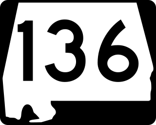
State Route 136 (SR 136) is a 6.151-mile (9.899 km) state highway in Monroe County in the southwestern part of the U.S. state of Alabama. The western terminus of the highway is at an intersection with SR 21 south of Monroeville. The eastern terminus of the route is at an intersection with U.S. Route 84 and SR 41 near the Monroe–Conecuh county line, at a point east of Excel.
There are 21 routes assigned to the "E" zone of the California Route Marker Program, which designates county routes in California. The "E" zone includes county highways in Alpine, Amador, Butte, Calaveras, El Dorado, Placer, Plumas, Sacramento, Solano, Tuolumne, Yolo, and Yuba counties.
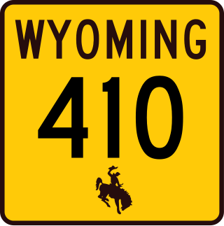
Wyoming Highway 410 (WYO 410) is a 13.36-mile (21.50 km) state highway in Uinta County, Wyoming, United States, that connects areas west of Roberston with Mountain View.

Dewey is an unincorporated community near the southwest corner of Custer County, South Dakota, United States, less than one mile from the Wyoming border in a prairie region of the Black Hills. There are approximately five or six homes in town. Dewey has a volunteer fire department in the Edgemont city district.
Parham Road is a circumferential highway in Henrico County in the U.S. state of Virginia. The highway runs 12.08 miles (19.44 km) from Virginia State Route 150 near Tuckahoe east to U.S. Route 301 and SR 2 in Chamberlayne. Parham Road serves the northwestern suburbs of Richmond, including Tuckahoe, Laurel, and Chamberlayne. The four-lane divided highway intersects all of the major highways that extend northwest and north from the city, including Interstate 64 (I-64) and I-95. Parham Road is county maintained except for the portion that is State Route 73, a connector between US 1 and I-95. The Parham Road name was applied to a small portion of the current route by the early 20th century. SR 73 was constructed in the early 1960s. Most of Parham Road from SR 6 to US 1 was constructed as a new four-lane divided highway by Henrico County in the late 1960s; the existing sections were upgraded at the same time. The highway was extended east to its present terminus in the late 1970s. Parham Road was completed south to its present western terminus in 1990 concurrent with the extension of SR 150 across the James River from the Southside of Richmond to Henrico County.
References
- ↑ "Conicville Census Designated Place". Geographic Names Information System . United States Geological Survey, United States Department of the Interior . Retrieved February 6, 2023.
Municipalities and communities of Shenandoah County, Virginia, United States | ||
|---|---|---|
| Towns |  | |
| CDPs | ||
| Villages | ||
| Hamlets | ||
| Thorps | ||
| General | |
|---|---|
| National libraries | |
| | This Shenandoah County, Virginia state location article is a stub. You can help Wikipedia by expanding it. |