Conway, North Carolina

Last updated

Conway, North Carolina
Conway, North Carolina.jpg
Commercial buildings on South Church Street
NCMap-doton-Conway.PNG
Location of Conway, North Carolina
Coordinates: 36°26′14″N77°13′44″W / 36.43722°N 77.22889°W / 36.43722; -77.22889
Country United States
State North Carolina
County Northampton
Area
[1]
  Total1.82 sq mi (4.72 km2)
  Land1.82 sq mi (4.72 km2)
  Water0.00 sq mi (0.00 km2)
Elevation
[2]
102 ft (31 m)
Population
 (2020)
  Total752
  Density412.28/sq mi (159.21/km2)
Time zone UTC-5 (Eastern (EST))
  Summer (DST) UTC-4 (EDT)
ZIP code
27820
Area code 252
FIPS code 37-14400 [3]
GNIS feature ID2406307 [2]

Conway is a town in Northampton County, North Carolina, United States. The population was 836 at the 2010 census. It is part of the Roanoke Rapids, North Carolina Micropolitan Statistical Area.

Contents

Geography

According to the United States Census Bureau, the town has a total area of 1.8 square miles (4.7 km2), all land.

Demographics

Historical population
CensusPop.Note
1920 294
1930 40036.1%
1940 44912.3%
1950 61837.6%
1960 6627.1%
1970 6944.8%
1980 678−2.3%
1990 75911.9%
2000 734−3.3%
2010 83613.9%
2020 752−10.0%
U.S. Decennial Census [4]

2020 census

Conway racial composition [5]
RaceNumberPercentage
White (non-Hispanic)36949.07%
Black or African American (non-Hispanic)33844.95%
Native American 10.13%
Asian 10.13%
Other/Mixed 273.59%
Hispanic or Latino 162.13%

As of the 2020 United States census, there were 752 people, 306 households, and 221 families residing in the town.

2010 census

As of the 2010 United States Census, there were 836 people living in the town. The racial makeup of the town was 48.6% White, 47.7% Black and 1.3% from two or more races. 2.4% were Hispanic or Latino of any race.

2000 census

As of the census [3] of 2000, there were 734 people, 328 households, and 205 families living in the town. The population density was 406.0 inhabitants per square mile (156.8/km2). There were 356 housing units at an average density of 196.9 per square mile (76.0/km2). The racial makeup of the town was 65.53% White, 33.24% African American, 0.54% Native American, and 0.68% from two or more races. Hispanic or Latino of any race were 0.27% of the population.

There were 328 households, out of which 27.7% had children under the age of 18 living with them, 41.8% were married couples living together, 18.0% had a female householder with no husband present, and 37.5% were non-families. 35.1% of all households were made up of individuals, and 14.9% had someone living alone who was 65 years of age or older. The average household size was 2.24 and the average family size was 2.88.

In the town, the population was spread out, with 24.5% under the age of 18, 7.2% from 18 to 24, 23.7% from 25 to 44, 25.6% from 45 to 64, and 18.9% who were 65 years of age or older. The median age was 42 years. For every 100 females, there were 75.6 males. For every 100 females age 18 and over, there were 66.9 males.

The median income for a household in the town was $23,250, and the median income for a family was $27,386. Males had a median income of $26,932 versus $21,538 for females. The per capita income for the town was $14,969. About 24.9% of families and 24.1% of the population were below the poverty line, including 36.3% of those under age 18 and 21.1% of those age 65 or over.

Notable people

Related Research Articles

<span class="mw-page-title-main">Midfield, Alabama</span> Town in Alabama, United States

Midfield is a town in Jefferson County, Alabama, United States, located two miles south of the Birmingham suburb of Fairfield. It incorporated in 1953. As of the 2020 census, it had a population of 5,211.

<span class="mw-page-title-main">Conway, Iowa</span> City in Iowa, United States

Conway is a city in Taylor County, Iowa, United States. The population was 17 at the 2020 census. Making it the third smallest incorporated place in Iowa.

Detroit is a town in Somerset County, Maine, United States. The population was 885 at the 2020 census.

<span class="mw-page-title-main">Elk Park, North Carolina</span> Town in North Carolina, United States

Elk Park is a town in Avery County, North Carolina, United States. The town was so named because of the number of elk killed there. The population was 452 at the 2010 census.

<span class="mw-page-title-main">Waco, North Carolina</span> Town in North Carolina, United States

Waco is a town in Cleveland County, North Carolina, United States. The population was 321 at the 2010 census.

<span class="mw-page-title-main">Bridgeton, North Carolina</span> Town in North Carolina, United States

Bridgeton is a town in Craven County, North Carolina, United States. The population was 454 at the 2010 census. It is part of the New Bern, North Carolina Micropolitan Statistical Area.

<span class="mw-page-title-main">Woodland, North Carolina</span> Town in North Carolina, United States

Woodland is a town in Northampton County, North Carolina, United States. The population was 809 at the 2010 census. It is part of the Roanoke Rapids, North Carolina Micropolitan Statistical Area.

<span class="mw-page-title-main">Cleveland, North Carolina</span> Town in North Carolina, United States

Cleveland is a town in the Cleveland Township of Rowan County, North Carolina, United States. The population was 871 at the 2010 census.

<span class="mw-page-title-main">Badin, North Carolina</span> Town in North Carolina, United States

Badin is a town located in Stanly County, North Carolina, United States. At the 2010 census, the town had a total population of 1,974.

<span class="mw-page-title-main">Hanover, Ohio</span> Village in Ohio, United States

Hanover is a village in Licking County, Ohio, United States. The population was 1,270 at the 2020 census. The village lies along Ohio State Route 16.

<span class="mw-page-title-main">Elmhurst Township, Lackawanna County, Pennsylvania</span> Place in Pennsylvania, United States

Elmhurst Township is a township in Lackawanna County, Pennsylvania, United States. The population was 836 at the 2020 census.

<span class="mw-page-title-main">Donalds, South Carolina</span> Town in South Carolina, United States

Donalds is a town in Abbeville County, South Carolina. As of the 2020 United States Census, its population was 328.

<span class="mw-page-title-main">Ridgeway, South Carolina</span> Town in South Carolina, United States

Ridgeway is a town in Fairfield County, South Carolina, United States. The population was 319 at the 2010 census. It is part of the Columbia, SC Metropolitan Statistical Area.

<span class="mw-page-title-main">Aynor, South Carolina</span> Town in South Carolina, United States

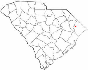
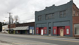
Aynor is a small town in Horry County, South Carolina, United States, south of Galivants Ferry. The population was 560 at the 2010 census and estimated in 2018 to be 934. Aynor High School consistently ranks as one of the best schools in Horry County and South Carolina.

<span class="mw-page-title-main">Red Hill, South Carolina</span> Census-designated place in South Carolina, United States

Red Hill is a census-designated place (CDP) in Horry County, South Carolina, United States. The population was 13,223 at the 2010 census, up from 10,509 at the 2000 census.

<span class="mw-page-title-main">Heath Springs, South Carolina</span> Town in South Carolina, United States

Heath Springs is a town in Lancaster County, South Carolina, United States. The population was 742 at the 2020 census.

<span class="mw-page-title-main">Plymouth, Utah</span> Town in Utah, United States

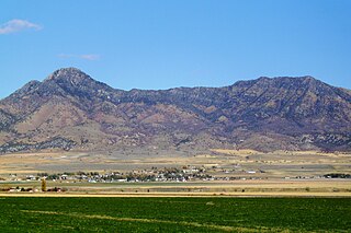
Plymouth is a town in Box Elder County, Utah, United States. The population was 414 at the 2010 census.

<span class="mw-page-title-main">Lorain, Wisconsin</span> Town in Wisconsin, United States

Lorain is a town in Polk County, Wisconsin, United States. The population was 328 at the 2000 census. The unincorporated community of Indian Creek is located in the town.

<span class="mw-page-title-main">Falcon, North Carolina</span> Town in North Carolina, United States

Falcon is a town in Cumberland and Sampson counties in the U.S. state of North Carolina. The population was 258 at the 2010 census.

Iola is a town in Waupaca County, Wisconsin, United States. The population was 818 at the 2000 census. The Village of Iola is located partially within the town. The ghost town of Petersville was also located in the town.

References

  1. "ArcGIS REST Services Directory". United States Census Bureau. Retrieved September 20, 2022.
  2. 1 2 U.S. Geological Survey Geographic Names Information System: Conway, North Carolina
  3. 1 2 "U.S. Census website". United States Census Bureau . Retrieved January 31, 2008.
  4. "Census of Population and Housing". Census.gov. Retrieved June 4, 2015.
  5. "Explore Census Data". data.census.gov. Retrieved December 24, 2021.
  6. The Baseball Cube. Retrieved 2018-11-06, from http://www.thebaseballcube.com/players/profile.asp?ID=11479
  7. Fred Vinson (2014) - Hall of Fame - Chowan University Athletics. Retrieved July 8, 2020.