Garysburg, North Carolina

Last updated

Garysburg, North Carolina
Garysburg, Norh Carolina.jpg
NCMap-doton-Garysburg.PNG
Location of Garysburg, North Carolina
Coordinates: 36°26′52″N77°33′37″W / 36.44778°N 77.56028°W / 36.44778; -77.56028
Country United States
State North Carolina
County Northampton
Area
[1]
  Total0.94 sq mi (2.44 km2)
  Land0.94 sq mi (2.44 km2)
  Water0.00 sq mi (0.00 km2)
Elevation
[2]
138 ft (42 m)
Population
 (2020)
  Total904
  Density958.64/sq mi (369.95/km2)
Time zone UTC-5 (Eastern (EST))
  Summer (DST) UTC-4 (EDT)
ZIP code
27831
Area code 252
FIPS code 37-25540 [3]
GNIS feature ID2406548 [2]

Garysburg is a town in Northampton County, North Carolina, United States. The population was 1,057 at the 2010 census. It is part of the Roanoke Rapids, North Carolina Micropolitan Statistical Area.

Contents

History

Garysburg is named for Roderick B. Gary. [4]

The Garysburg United Methodist Church and Cemetery and Mason-Hardee-Capel House are listed on the National Register of Historic Places. [5] In 1848, Garysburg was a stop on the Petersburg Railroad.

Geography

According to the United States Census Bureau, the town has a total area of 1.0 square mile (2.6 km2), all land.

Demographics

Historical population
CensusPop.Note
1880 97
1900 269
1910 169−37.2%
1920 20320.1%
1930 28439.9%
1940 32012.7%
1950 3447.5%
1960 181−47.4%
1970 23127.6%
1980 1,434520.8%
1990 1,057−26.3%
2000 1,25418.6%
2010 1,057−15.7%
2020 904−14.5%
U.S. Decennial Census [6]

2020 census

Garysburg racial composition [7]
RaceNumberPercentage
White (non-Hispanic)212.32%
Black or African American (non-Hispanic)86295.35%
Asian 10.11%
Other/Mixed 141.55%
Hispanic or Latino 60.66%

As of the 2020 United States census, there were 904 people, 414 households, and 267 families residing in the town.

2010 census

As of the 2010 United States Census, there were 1,057 people living in the town. The racial makeup of the town was 95.0% Black, 2.4% White, 0.9% Native American and 1.0% from two or more races. 0.8% were Hispanic or Latino of any race.

2000 census

As of the census [3] of 2000, there were 1,254 people, 482 households, and 334 families living in the town. The population density was 1,302.4 inhabitants per square mile (502.9/km2). There were 526 housing units at an average density of 546.3 per square mile (210.9/km2). The racial makeup of the town was 2.39% White, 96.09% African American, 0.64% Native American, 0.24% Asian, 0.40% from other races, and 0.24% from two or more races. Hispanic or Latino of any race were 0.40% of the population.

There were 482 households, out of which 29.3% had children under the age of 18 living with them, 34.4% were married couples living together, 30.9% had a female householder with no husband present, and 30.5% were non-families. 27.8% of all households were made up of individuals, and 12.4% had someone living alone who was 65 years of age or older. The average household size was 2.59 and the average family size was 3.16.

In the town, the population was spread out, with 28.1% under the age of 18, 8.5% from 18 to 24, 24.5% from 25 to 44, 24.0% from 45 to 64, and 14.9% who were 65 years of age or older. The median age was 38 years. For every 100 females, there were 81.5 males. For every 100 females age 18 and over, there were 73.3 males.

The median income for a household in the town was $22,604, and the median income for a family was $27,386. Males had a median income of $23,333 versus $20,682 for females. The per capita income for the town was $14,172. About 22.9% of families and 28.4% of the population were below the poverty line, including 34.8% of those under age 18 and 25.2% of those age 65 or over.

Notable person

Related Research Articles

<span class="mw-page-title-main">Astatula, Florida</span> Town in the state of Florida, United States

Astatula is a town in Lake County, Florida, United States. The population was 1,889 at the 2020 census. It is part of the Orlando–Kissimmee–Sanford Metropolitan Statistical Area.

<span class="mw-page-title-main">Bentley, Kansas</span> City in Sedgwick County, Kansas

Bentley is a city in Sedgwick County, Kansas, United States. As of the 2020 census, the population of the city was 560. It is located northwest of Wichita, approximately 4 miles north of K-96 highway at the intersection of 151st W & 109th N.

<span class="mw-page-title-main">Washington Park, North Carolina</span> Town in North Carolina, United States

Washington Park is a town in Beaufort County, North Carolina, United States. The population was 451 at the 2010 Census.

<span class="mw-page-title-main">Stokesdale, North Carolina</span> Town in North Carolina, United States

Stokesdale is a town in Guilford County, North Carolina, United States with small parts in the counties of Rockingham, Forsyth, and Stokes. The population was 5,924 at the 2020 census. Belews Lake is located nearby, and North Carolina Highway 68 and North Carolina Highway 65 both intersect U.S. Route 158 near the town's center.

<span class="mw-page-title-main">Candor, North Carolina</span> Town in North Carolina, United States

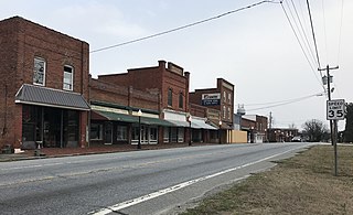
Candor is a town in Montgomery County, North Carolina, United States. The population was 840 at the 2010 census. Candor is the home of the North Carolina Peach Festival, which is held every year on the third Saturday of July. The town's welcome sign reads: Welcome to Candor. Peach Capital.

<span class="mw-page-title-main">Momeyer, North Carolina</span> Town in North Carolina, United States

Momeyer is a town in Nash County, North Carolina, United States. It is part of the Rocky Mount, North Carolina Metropolitan Statistical Area. The population was 277 in 2020.

<span class="mw-page-title-main">Spring Hope, North Carolina</span> Town in North Carolina, United States

Spring Hope is a town in Nash County, North Carolina, United States. It is part of the Rocky Mount, North Carolina Metropolitan Statistical Area. The population was 1,320 at the 2010 census.

<span class="mw-page-title-main">Burgaw, North Carolina</span> Town in North Carolina, United States

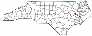
Burgaw is a town in, and the county seat of, Pender County, North Carolina, United States. The population was 3,088 at the 2020 census.

<span class="mw-page-title-main">Watha, North Carolina</span> Town in North Carolina, United States

Watha is a town in Pender County, North Carolina, United States. The population was 190 at the 2010 census. It is part of the Wilmington Metropolitan Statistical Area.

<span class="mw-page-title-main">Columbus, North Carolina</span> Town in North Carolina, United States

Columbus is a town and the county seat of Polk County, North Carolina, United States. The population was 999 at the 2010 census.

<span class="mw-page-title-main">Franklinville, North Carolina</span> Town in North Carolina, United States

Franklinville is a town in Randolph County, North Carolina, United States. The population was 1,164 at the 2010 census.

<span class="mw-page-title-main">Norlina, North Carolina</span> Town in North Carolina, United States

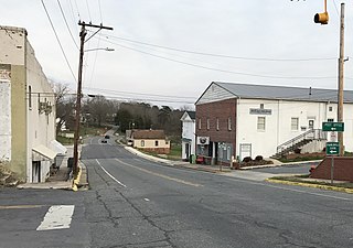
Norlina is a town in Warren County, North Carolina, United States. The population was 1,118 at the 2010 census.

<span class="mw-page-title-main">Churchill, Ohio</span> Census-designated place in Ohio, United States

Churchill is a census-designated place in Liberty Township, Trumbull County, Ohio, United States. The population was 2,176 at the 2020 census. It is part of Youngstown–Warren metropolitan area. The community was named for a hilltop church near the original townsite.

Pine Ridge is a town in Lexington County, South Carolina, United States. The population was 2,064 at the 2010 census. It is part of the Columbia, South Carolina Metropolitan Statistical Area.

Springdale is a town in Lexington County, South Carolina, United States. The population was 2,636 at the 2010 census. It is part of the Columbia Metropolitan Statistical Area.

<span class="mw-page-title-main">Parksville, South Carolina</span> Town in South Carolina, United States

Parksville is a town in McCormick County, South Carolina, United States. The population was 117 at the 2010 census.

<span class="mw-page-title-main">Plum Branch, South Carolina</span> Town in South Carolina, United States

Plum Branch is a town in McCormick County, South Carolina, United States. The population was 82 at the 2010 census.

<span class="mw-page-title-main">Hudson, South Dakota</span> Town in South Dakota, United States

Hudson is a town in Lincoln County, South Dakota, United States. The population was 311 at the 2020 census. It is the easternmost community in South Dakota.

<span class="mw-page-title-main">Redfield, South Dakota</span> City in South Dakota, United States

Redfield is a city in and the county seat of Spink County, South Dakota, United States. The population was 2,214 at the 2020 census. The city was named for J. B. Redfield, a railroad official.

<span class="mw-page-title-main">Pine Grove, West Virginia</span> Town in West Virginia, United States

Pine Grove is a town in Wetzel County, West Virginia, United States. The population was 363 at the 2020 census. The community was named for a grove of pine trees near the original town site.

References

  1. "ArcGIS REST Services Directory". United States Census Bureau. Retrieved September 20, 2022.
  2. 1 2 U.S. Geological Survey Geographic Names Information System: Garysburg, North Carolina
  3. 1 2 "U.S. Census website". United States Census Bureau . Retrieved January 31, 2008.
  4. Gannett, Henry (1905). The Origin of Certain Place Names in the United States. Govt. Print. Off. pp.  135.
  5. "National Register Information System". National Register of Historic Places . National Park Service. July 9, 2010.
  6. "Census of Population and Housing". Census.gov. Retrieved June 4, 2015.
  7. "Explore Census Data". data.census.gov. Retrieved December 24, 2021.