Related Research Articles

The Rocky Mountains, also known as the Rockies, are a major mountain range and the largest mountain system in North America. The Rocky Mountains stretch 3,000 miles in straight-line distance from the northernmost part of western Canada, to New Mexico in the southwestern United States. Depending on differing definitions between Canada and the U.S., its northern terminus is located either in northern British Columbia's Terminal Range south of the Liard River and east of the Trench, or in the northeastern foothills of the Brooks Range/British Mountains that face the Beaufort Sea coasts between the Canning River and the Firth River across the Alaska-Yukon border. Its southernmost point is near the Albuquerque area adjacent to the Rio Grande rift and north of the Sandia–Manzano Mountain Range. Being the easternmost portion of the North American Cordillera, the Rockies are distinct from the tectonically younger Cascade Range and Sierra Nevada, which both lie farther to its west.
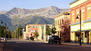
Fernie is a city in the Elk Valley area of the East Kootenay region of southeastern British Columbia, Canada, located on BC Highway 3 on the western approaches to the Crowsnest Pass through the Rocky Mountains. Founded in 1898 and incorporated as the City of Fernie in July 1904, the municipality has a population of over 5,000 with an additional 2,000 outside city limits in communities under the jurisdiction of the Regional District of East Kootenay. A substantial seasonal population swells the city during the winter months.

Crowsnest Pass is a low mountain pass across the Continental Divide of the Canadian Rockies on the Alberta–British Columbia border.

Lake Koocanusa is a reservoir in British Columbia (Canada) and Montana formed by the damming of the Kootenai River by the Libby Dam in 1972. The Dam was formally dedicated by President Gerald Ford on August 24, 1975.

The Elk River is a 220-kilometre (140 mi) long river, in the southeastern Kootenay district of the Canadian province of British Columbia. Its drainage basin is 4,450 square kilometres (1,720 sq mi) in area. Its mean discharge is approximately 60 cubic metres per second (2,100 cu ft/s), with a maximum recorded discharge of 818 cubic metres per second (28,900 cu ft/s). It is a tributary of the Kootenay River, and falls within the basin of the Columbia River.

The Kootenay River or Kootenai River is a major river in the Northwest Plateau, in southeastern British Columbia, Canada, and northern Montana and Idaho in the United States. It is one of the uppermost major tributaries of the Columbia River, the largest North American river that empties into the Pacific Ocean. The Kootenay River runs 781 kilometres (485 mi) from its headwaters in the Kootenay Ranges of the Canadian Rockies, flowing from British Columbia's East Kootenay region into northwestern Montana, then west into the northernmost Idaho Panhandle and returning to British Columbia in the West Kootenay region, where it joins the Columbia at Castlegar.
Teck Resources Limited, known as Teck Cominco until late 2008, is a diversified natural resources company headquartered in Vancouver, British Columbia, that is engaged in mining and mineral development, including coal for the steelmaking industry, copper, zinc, and energy. Secondary products include lead, silver, gold, molybdenum, germanium, indium and cadmium. Teck Resources was formed from the amalgamation of Teck and Cominco in 2001.
Elkford is a district municipality in the southeast region of the Canadian province of British Columbia in the Rocky Mountain range. It is 32 km (20 mi) north of the junction at Sparwood, on provincial Highway 43. Outdoor recreational activities take place in Elkford throughout the year. Elkford hosts an annual festival called Wildcat Days during the last weekend of June.

Nordegg is a hamlet in west-central Alberta, Canada within Clearwater County. It is located in the North Saskatchewan River valley in the foothills of the Canadian Rockies, just east of the intersection of the David Thompson Highway and the Highway 734 spur of the Bighorn Highway. A former coal mining town, it was named after Martin Nordegg and the name probably means "North Corner" in a German dialect. The railway station name at the locality was called Brazeau rather than Nordegg at certain points in its history, but the local post office has always been named Nordegg. The name Brazeau is now obsolete.

The Elk Valley is a valley in the southeastern Kootenay region of British Columbia, Canada. Located in the heart of the Canadian Rockies, the Elk Valley is approximately 60 kilometres from the Alberta and Montana borders.
Alexo is a ghost town in Alberta, Canada. Built as a coal mining town, it lies in the foothills of the Canadian Rockies at an elevation of about 1,260 metres (4,130 ft), near the David Thompson Highway between the towns of Nordegg and Rocky Mountain House. The Town of Alexo has recently been transformed into a summer camp by YouthHQ which operates out of Red Deer, Alberta. Shunda Creek and the North Saskatchewan River run to the south of it.

Mountain Park is a ghost town in western Alberta, south of Cadomin, elevation 6200 feet, at the end of the historic Alberta Coal Branch line of the Canadian National Railway.
Coal reserves in Canada rank 13th largest in the world at approximately 10 billion tons, 0.6% of the world total. This represents more energy than all of the oil and gas in the country combined. The coal industry generates CDN$5 billion annually. Most of Canada's coal mining occurs in the West of the country. British Columbia operates 9 coal mines, Alberta nine, Saskatchewan three and New Brunswick one. Nova Scotia operates several small-scale mines, Westray having closed following the 1992 disaster there.

Trail is a city in the West Kootenay region of the Interior of British Columbia, Canada. It was named after the Dewdney Trail, which passed through the area. The town was first called Trail Creek or Trail Creek Landing, and the name was shortened to Trail in 1897.
Bullhead Group is a stratigraphic unit of Lower Cretaceous age in the Western Canada Sedimentary Basin of northeastern British Columbia and western Alberta. It was first defined by F.H. McLearn in 1918 as the Bullhead Mountain Formation, but later was upgraded to group status. It consists of the Cadomin and Gething Formations, although some early workers included the Bluesky Formation and others in the group.
The Mist Mountain Formation is a geologic formation of latest Jurassic to earliest Cretaceous age in the Western Canada Sedimentary Basin that is present in the southern and central Canadian Rockies. It was named for outcrops along the western spur of Mist Mountain in Alberta by D.W. Gibson in 1979. The Mist Mountain Formation contains economically important coal seams that have been mined in southeastern British Columbia and southwestern Alberta.
The Elk Formation is a stratigraphic unit of the Western Canada Sedimentary Basin that is present in southeastern British Columbia and southwestern Alberta. It is probably of Early Cretaceous age, but in some areas its strata could be as old as Late Jurassic. It includes minor thin coal beds and was named for outcrops near the now-abandoned Elk River coal mine east of Fernie, British Columbia.
The Kootenay Group, originally called the Kootenay Formation, is a geologic unit of latest Jurassic to earliest Cretaceous age in the Western Canada Sedimentary Basin that is present in the southern and central Canadian Rockies and foothills. It includes economically important deposits of high-rank bituminous and semi-anthracite coal, as well as plant fossils and dinosaur trackways.

The Burnley Coalfield is the most northerly portion of the Lancashire Coalfield. Surrounding Burnley, Nelson, Blackburn and Accrington, it is separated from the larger southern part by an area of Millstone Grit that forms the Rossendale anticline. Occupying a syncline, it stretches from Blackburn past Colne to the Yorkshire border where its eastern flank is the Pennine anticline.

Hewitt Peak is a 3,066-metre (10,059 ft) mountain summit located on the western border of Kootenay National Park, in the Canadian Rockies of British Columbia, Canada. The peak is also known locally as Mammoth Peak, and originally as Mount 10060. The alternate names derive from its outline profile resembling a mammoth, and its elevation as measured in feet. No name for this mountain has been officially adopted yet. Its nearest higher peak is Tumbling Peak, 2.5 km (1.6 mi) to the north-northwest, and both are part of the Vermilion Range. Park visitors can catch a glimpse of the peak from Highway 93, also known as the Banff–Windermere Highway.
References
- ↑ "Corbin". BC Geographical Names . Retrieved 2011-11-07.
- 1 2 3 Teck Resources Ltd., 2018. "The Story of Coal Mountain". www.teck.com. Retrieved 9 June 2019.
- 1 2 3 MacKay, B.R. 1931a. Corbin Coal Field. Geological Survey of Canada, Summary Report, 1930, Part A, p. 154A-179A.
- ↑ Barlee, N.L. (1973), Gold Creeks and Ghost Towns. Canada West Publications.
- 1 2 3 4 Foster, S. and Bachusky, J. 2005. "Corbin, Workers' Hell at Coal Mountain". Ghost Towns of British Columbia. Retrieved 9 June 2019.
{{cite web}}: CS1 maint: multiple names: authors list (link) - ↑ MacKay, B.R., 1931b. Corbin area, Kootenay District, British Columbia. Geological Survey of Canada, Map 279A.
- 1 2 British Columbia coal industry overview, 2018, British Columbia Ministry of Energy, Mines and Petroleum Resources, British Columbia Geological Survey, Information Circular 2019-02, p. 3 and 7.