Cosby, Leicestershire

Last updated
Cosby
The Nook, Cosby, Leicestershire - geograph.org.uk - 164608.jpg
Leicestershire UK location map.svg
Red pog.svg
Cosby
Location within Leicestershire
Population3,506 
District
Shire county
Region
Country England
Sovereign state United Kingdom
Post town LEICESTER
Postcode district LE9
Police Leicestershire
Fire Leicestershire
Ambulance East Midlands
UK Parliament
List of places
UK
England
Leicestershire
52°33.1′N1°11.6′W / 52.5517°N 1.1933°W / 52.5517; -1.1933

Cosby Village centre Cosby village centre.jpg
Cosby Village centre

Cosby is a village in the English county of Leicestershire. Cosby is located in the south of the county near the larger villages and towns of Whetstone, Blaby , Wigston and Oadby. Its proximity to the city of Leicester means it is part of the Leicester Urban Area. The village is administered by Blaby District Council. Cosby has a brook which runs through the village and eventually serves as a tributary to the River Soar, then runs into the river Humber and then into the North Sea. Even though The Wash is 59 miles away there is no source of the river in Cosby. London is 80 miles away, and the closest airports are East Midlands Airport (EMA) and Birmingham Airport (BHX)

Contents

The village's name probably means 'farm/settlement of Cossa'. 'Farm/settlement of Kofsi' has also been suggested. [1]

History

Cosby's 'Scandinavian' place name indicates that the village existed here several hundred years earlier, dating to the time of the Danish invasion in the earlier parts of the 9th century. However it is possible that there may have been an even earlier settlement here in Saxon or even Roman times given that the Fosse Way bounds the parish to the north.

Cosby is first recorded as "Cossebi" in the Domesday Book in 1086 with 40 families living in the village. Cosby was described as a "considerable village" in 1810 (with a population of 555) by historian John Nichols. In 1991 it had a population of 3,400 and in 2001 a population of 3,489, increasing to 3,506 at the 2011 census. [2] 2022 census increased to 3,909 with demographics of 95% White British, 2% south Mediterranean/ Cypriot/ Turkish. 2% Asian. 1% Eastern European.

Church of St Michael and All Angels, Cosby St. Michael and All Angels', Cosby - geograph.org.uk - 509656.jpg
Church of St Michael and All Angels, Cosby

The parish church is the 14th century St Michael and All Angels'. It also has Methodist and Baptist churches. Cosby has two schools, Cosby Primary School and independent school Brooke House Day School. Cosby has football, rugby and cricket teams which all participate in Leicestershire's sporting leagues. The teams play their home games at Victory Park.

A 15th century granary, known as the Tithe Barn, sits next to the church and now forms a popular dining venue. It was taken over by H.W. Coates in the 1960s and known as the Coates Barn, before being restored in the 1980s into commercial office space. Original wattle and daub was saved along with other period elements and these are now on display for patrons. [3] [4] [5]

Close to the church is the early 17th century house known as Brooks Edge. This is the historic home of the Armston family who lived in the village for more than 800 years. One member of this pro-Royalist family escaped after the Battle of Naseby and hid out in Whetstone Gorse. Cromwell's soldiers questioned many people as to his whereabouts, including his small son who refused to divulge his father's hiding place. According to the legend, this took place in the family home at Brooks Edge and was celebrated in William Frederick Yeames's famous painting And When Did You Last See Your Father?.[ citation needed ]

In 1767, the medieval open fields of the village were enclosed by Act of Parliament, bringing to an end the system of agriculture, which had been practiced in Cosby from before the Norman Conquest in 1066. The post enclosure revolution in farming resulted in Cosby becoming a more industrial village with framework knitting followed by boot and shoe manufacture dominating the 19th and early 20th centuries. During this period, the population of the village more than doubled from 555 in 1801 to 1,351 in 1901.

Council houses were built along Park Road and in Lady Leys during the 1920s and 1930s, while the Settlement was established in 1938 when 48 houses each with a third of an acre to house out of work families from Wales and the North East of England. By 1951 the population had risen to 1,533, five times that of the village in the 17th century. In the 1960s large private housing estates were also built making the village one of Leicestershire's increasing number of dormitory settlements.

The Great Central Railway, the last main line to be built from the north of England to London, opened on 15 Mar 1899 and ran past the east side of Cosby on an embankment. Although there was never a station at Cosby, this section of the line was well known for the lengthy curve which for northbound trains was to the right (east), after coming out of which the city of Leicester would be directly ahead and the route would be almost ruler straight all the rest of the way to the centre of the city, a distance of almost 5 miles (8 km). Railwaymen referred to this curve as Cosby Corner. The line closed on 5 May 1969; today the rear gardens of many adjacent homes have been extended up over the embankment.

The "Victory Show", a commemoration of World War II, is held at Foxlands Farm on a 100-acre site in September and is the largest event in the country. The show hosts re-enactments of military events.

Sport

Cosby has a non-league football team Saffron Dynamo F.C., who play at King's Park, Cambridge Road, in the United Counties League Division One. [6]

In 2009, Sir Garfield Sobers came to the village at a special evening when he talked about his cricket career. The former West Indies captain returned a few days later to join members who had successfully bid to play a round of golf with him. His visits came during a busy spell for Cosby when they hosted the County Championship at the end of June of that year.

In September 2011, Cosby's Lucy Garner sprinted to victory in Copenhagen to claim the Junior Women's World Championship. She finished in the Top 3 of the 2011 BBC Young Sports Personality of the Year Award category. In May 2012, Garner added the National Junior Road Race title to her Junior World Title.

In the 2014-15 football season, Cosby United won an unprecedented treble by winning the Leicester and District Premier Division title, County Cup and League Cup.

In the 2017-18 rugby season, Cosby won the Leicestershire Merit C league title, losing just one game - a home defeat to Burbage 2nds. They exacted their revenge on Burbage though by winning at their ground, 17-15, in the final league game of the season in a top of the table title decider. In the football, Cosby United won the Leicester and District Premier Division title after beating Glenfield Town 7-1 in their final game of the season.

Related Research Articles

<span class="mw-page-title-main">Blaby District</span> Administrative district of Leicestershire, England, UK

Blaby is a local government district in Leicestershire, England.

<span class="mw-page-title-main">Blaby</span> Village in Leicestershire, England

Blaby is a large village in the Blaby District in central Leicestershire, England, some five miles south of Leicester city centre. At the time of the 2011 census, Blaby had a population of 6,194, a slight fall from 6,240 in 2001 figures). Blaby's proximity to the city causes it to form part of the Leicester Urban Area.

<span class="mw-page-title-main">Aylestone</span> Human settlement in England

Aylestone is a suburb of Leicester, England, southwest of the city centre and to the east of the River Soar. It was formerly a separate village, but the growth of the city since the Leicester Extension Act of 1891 incorporated Aylestone into the Borough of Leicester and it is now part of the suburban area.

<span class="mw-page-title-main">Anstey, Leicestershire</span> Human settlement in England

Anstey is a large village in Leicestershire, England, located north west of Leicester in the borough of Charnwood. Its population was 6,528 at the 2011 census. This figure is expected to increase due to the building of a new housing development off Groby Road. The village is separated from Leicester by the Rothley Brook, Castle Hill Park and the A46, and it borders the villages of Glenfield, Groby, Newtown Linford, Cropston and Thurcaston as well as the suburb of Beaumont Leys and Anstey Heights. To the north-west lies Bradgate Park.

<span class="mw-page-title-main">Narborough, Leicestershire</span> Human settlement in England

Narborough is a large village and civil parish in the Blaby district of Leicestershire, England, around six miles southwest of Leicester. The population of the civil parish at the 2011 census was 8,498.

<span class="mw-page-title-main">Blaby (UK Parliament constituency)</span> Parliamentary constituency in the United Kingdom, 1974–2010

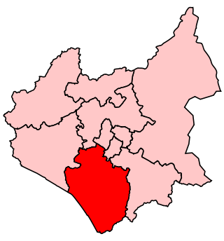
Blaby was a county constituency represented in the House of Commons of the Parliament of the United Kingdom, which existed from 1974 until 2010. It elected one Member of Parliament (MP) by the first past the post system of election. It was a safe seat for the Conservative Party, being held by Conservative MPs throughout its existence.

<span class="mw-page-title-main">Glen Parva</span> Human settlement in England

Glen Parva is a civil parish in the Blaby district of Leicestershire, England with a population of over 17,000. The population of the civil parish, including Eyres Monsell was 17,189 in the 2011 census. To the north it runs into Aylestone and to the east South Wigston. To the south and west it is not immediately surrounded by development.

<span class="mw-page-title-main">Countesthorpe</span> Human settlement in England

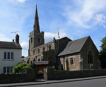
Countesthorpe is a large village and civil parish in the Leicestershire district of Blaby, with a population of 6,393 (2001 census, falling slightly to 6,377 at the 2011 census. It lies to the south of Leicester, and is about 6 miles from the city centre, but only two miles south of the suburb of South Wigston. Nearby places are Blaby and South Wigston to the north, Kilby to the east, Peatling Magna and Willoughby Waterleys to the south, and Broughton Astley, Cosby and Whetstone to the west.

<span class="mw-page-title-main">Broughton Astley</span> Human settlement in England

Broughton Astley is a large village and civil parish located in the Harborough district of Leicestershire, England. It is situated in the south of Leicestershire, about 6 miles (10 km) east of Hinckley, about 9 miles (14 km) from the centre of Leicester, and about 14 miles from Coventry. The parish borders the Blaby district to the north, as well as sharing borders with the parishes of Cosby, Leire, and Dunton Bassett. The population of the civil parish at the time of the 2011 census was 8,940. A tributary of the River Soar runs through it.

<span class="mw-page-title-main">Whetstone, Leicestershire</span> Human settlement in England

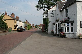
Whetstone is a village and civil parish in the Blaby district of Leicestershire, England and largely acts as a commuter village for Leicester, five miles to the north. The population at the 2011 census was 6,556. It is part of the Leicester Urban Area.

<span class="mw-page-title-main">South Wigston</span> Human settlement in England

South Wigston is a large village to the south of Leicester, England. It is outside the city boundary, forming part of the Oadby and Wigston district of Leicestershire. The population of the ward rose slightly from 7,471 at the 2001 census to 7,490 at the 2011 census.

<span class="mw-page-title-main">Elmesthorpe</span> Human settlement in England

Elmesthorpe is a village and civil parish in the Blaby district of Leicestershire, England. It is situated to the south-east of Earl Shilton, near to Hinckley on the A47 road. In 2004, the parish had an estimated population of 520, reducing to 509 at the 2011 census.

<span class="mw-page-title-main">Kilby</span> Human settlement in England

Kilby is a village and civil parish in the Blaby district of Leicestershire, England. Kilby is the easternmost village in the district, and is 6.1 miles (9.8 km) south east of Leicester. Kilby civil parish includes the former parish of Foston and it's deserted medieval village. Nearby places are Countesthorpe 2.21 miles (3.56 km), Fleckney 2.12 miles (3.41 km), Arnesby 1.96 miles (3.15 km), Wistow 1.4 miles (2.3 km) and Kilby Bridge 1.18 miles (1.90 km).

<span class="mw-page-title-main">Sharnford</span> Human settlement in England

Sharnford is a village and civil parish in Blaby of Leicestershire. The parish has a population of about 1,000, measured at the 2011 census as 985. The village is about four miles east of Hinckley, and is near to Aston Flamville, Wigston Parva and Sapcote.

<span class="mw-page-title-main">South Leicestershire (UK Parliament constituency)</span> Parliamentary constituency in the United Kingdom, 2010 onwards

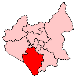
South Leicestershire is a constituency represented in the House of Commons of the UK Parliament since 2015 by Alberto Costa, a member of the Conservative Party.

<span class="mw-page-title-main">Blaby & Whetstone Athletic F.C.</span> Association football club in England

Blaby & Whetstone Athletic Football Club is a football club based in Whetstone, near Leicester, Leicestershire, England. They play at Warwick Road.

The Leicester and District Football League is an association football competition based in England. The league has three divisions, of which the highest, the Premier Division, sits at level 12 of the English football league system and is a feeder to the Leicestershire Senior League. There are also two reserve divisions which are not part of the league system.

References

  1. "Key to English Place-names". kepn.nottingham.ac.uk. Archived from the original on 10 August 2021. Retrieved 19 August 2021.
  2. "Civil Parish population 2016". Neighbourhood Statistics. Office for National Statistics. Archived from the original on 11 October 2016. Retrieved 10 June 2016.
  3. "Café – Deli | Tithe Barn Cosby Leicester". www.tithebarn.com. Retrieved 27 December 2021.
  4. Rogers, Joseph (2021). Tithe barns. Stroud, Gloucestershire. p. 32. ISBN   978-1-4456-9285-2. OCLC   1242784225.{{cite book}}: CS1 maint: location missing publisher (link)
  5. "COATES BARN, Cosby - 1361088 | Historic England". historicengland.org.uk. Retrieved 27 December 2021.
  6. Uhlsport United Counties Football League: SAFFRON DYNAMO FC – Uhlsport United Counties Football League Archived 6 February 2020 at the Wayback Machine , accessdate: February 5, 2020

52°33.1′N1°11.6′W / 52.5517°N 1.1933°W / 52.5517; -1.1933