
The Borough of Charnwood is a local government district with borough status in the north of Leicestershire, England, which has a population of 166,100 as of the 2011 census. It borders Melton to the east, Harborough to the south east, Leicester and Blaby to the south, Hinckley and Bosworth to the south west, North West Leicestershire to the west and Rushcliffe in Nottinghamshire to the north. It is named after Charnwood Forest, an area which the borough contains much of.

Blaby is a local government district in Leicestershire, England.

Hinckley and Bosworth is a local government district with borough status in south-western Leicestershire, England, administered by Hinckley and Bosworth Borough Council. Its only towns are Hinckley, Earl Shilton and Market Bosworth. Villages include Barwell, Burbage, Stoke Golding, Groby, Shackerstone and Twycross. The population of the Borough at the 2011 census was 105,078.

Leicester Forest East (LFE) is a settlement in Leicestershire, England, west of Leicester, straddling the M1 motorway. It is part of the Blaby district.

BBC Radio Leicester is the BBC's local radio station serving the counties of Leicestershire and Rutland.

The A5199 road is the direct road from Northampton to Leicester in England. It was formerly part of the A50 trunk road that ran from Bedfordshire to Lancashire. For most of its length it is known as the Welford Road, except for small stretches near Welford where it is known as High Street and Northampton Road, and a section near Wigston Magna where it is known as Bull Head Street.

Charnwood is a constituency represented in the House of Commons of the UK Parliament since 2015 by Edward Argar, a Conservative.
Bushbury South and Low Hill is a ward of Wolverhampton City Council, West Midlands, England. It is situated to the north of the city centre, bordering the Bushbury North, Fallings Park, Heath Town, St Peter's and Oxley wards, and forms part of the Wolverhampton North East constituency.

Stoughton is a village and civil parish in the Harborough district of Leicestershire. The population at the 2011 census was 351.

The A563 is the designation for the ring road of Leicester, England. It forms a near-complete circuit except for a gap of around 2.2 miles (3.5 km) in the east of the city. An indirect route linking the gap involves the (A47) A6030, and A6. The A563 was formerly referred to as the Outer Ring.

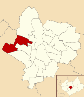
Braunstone is a civil parish and is the largest parish within the district of Blaby in Leicestershire, England, now known as the Town of Braunstone or more commonly, Braunstone Town. In 2007 the population was around 15,000. There are around 7,500 households including Thorpe Astley. At the 2011 census the population of the civil parish had increased to 16,850.
New Parks is residential suburb of the city of Leicester, England. It is also an electoral ward of the City of Leicester whose population at the 2011 Census was 17,128.
The Leicester Urban Area or Leicester Built Up Area is an urban agglomeration defined by the Office of National Statistics (ONS), centred on the City of Leicester in the English Midlands. With a population of 508,916 at the time of the 2011 census, the Built Up Area is the eleventh largest in England and thirteenth largest in the United Kingdom. It comprises Leicester itself and its suburbs, all of which are contiguous with, or situated in close proximity to, the city.
West Knighton is a community in Leicester in the United Kingdom.

Great Glen railway station was built by the Midland Railway in 1857 on its extension from Leicester to Bedford and Hitchin.
Lancaster Academy is a co-educational secondary school located in Knighton, Leicester, England.
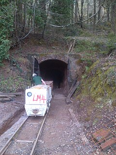
The Lea Bailey Light Railway is a 2 ft narrow-gauge heritage railway in the United Kingdom. It is built on the site of the Bailey Level Gold Mine
Bradgate House is a 19th-century ruin in Groby, Leicestershire, England.
Grace Dieu Halt railway station was a station on the Charnwood Forest Railway. At 52.761485°N 1.354311°E near the hamlet of Grace-Dieu, Leicestershire. On the outskirts of Whitwick. Opened in 1907 as a stop on the line between Loughborough Derby Road and Coalville East.
Thringstone Halt railway station was a station on the Charnwood Forest Railway. Near the village of Thringstone, Leicestershire at 52.7503354N 1.3638816E. On the outskirts of Whitwick. Opened in 1907 as a stop on the line between Loughborough Derby Road and Coalville East.
